
January 10, 2023 |
Multiple Authors | Infrastructure
November 24, 2025
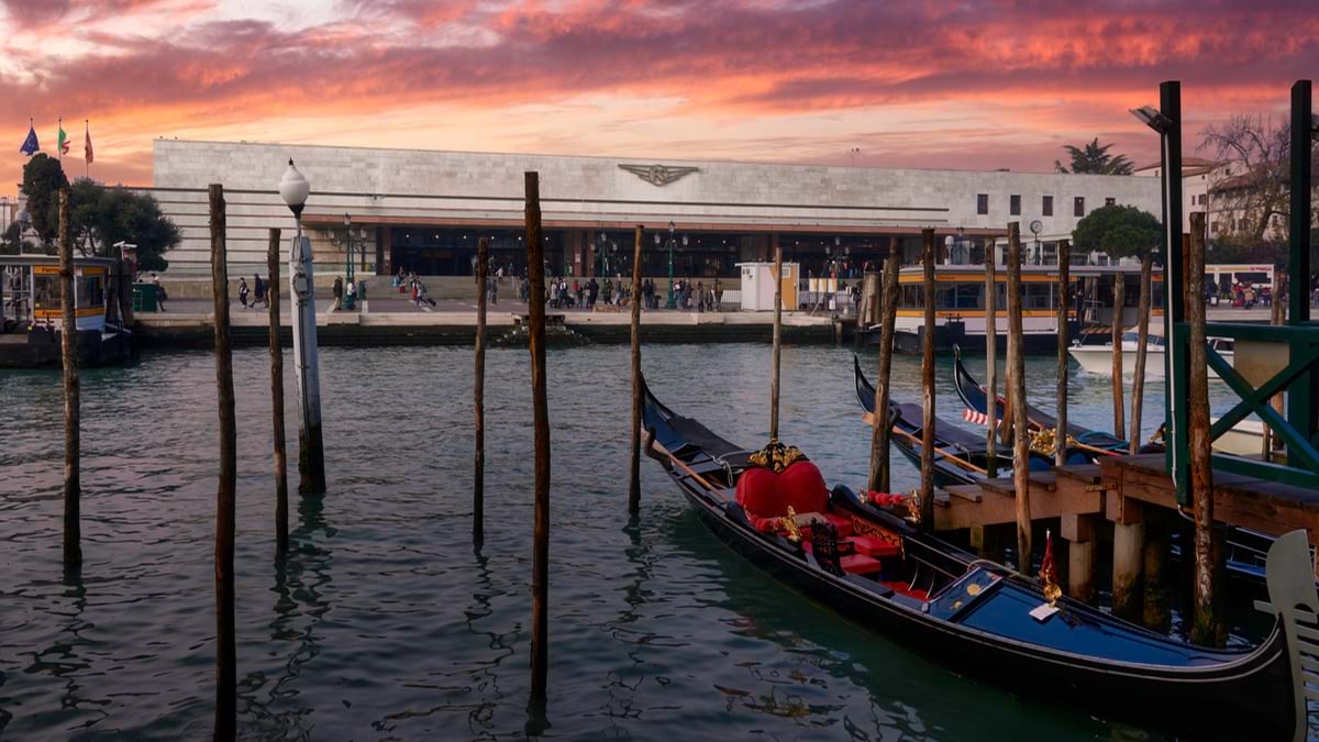
To appreciate why—and how—Italy is spending billions to renew hundreds of its railway stations, consider a hidden problem plaguing one of the country’s busiest hubs.
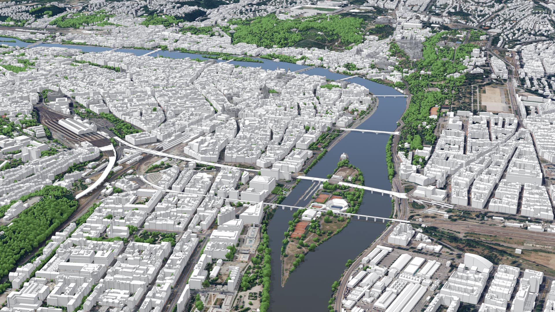
A few years ago, a team of analysts for the national railway company was studying how commuters traveled to and around Roma Trastevere, a station near Rome’s city center that was last renovated in 1911. Most Italian train riders walk to stations and will typically tolerate a 15-minute walk, research indicates. But surveys of Roma Trastevere travelers found that pedestrians coming from some neighborhoods faced a circuitous half-hour walk along a busy road to reach the main entrance. Despite the station’s bustling northern side serving the vibrant neighborhood of Trastevere, the southern streetscape was effectively turning away thousands of people each day from neighborhoods like Marconi and Monteverde.
“We were forgetting all the people that lived and worked around there,” said Luigi Contestabile, the head of station services development for Rete Ferroviaria Italiana (RFI), the public company that manages Italy’s rail infrastructure for the national rail carrier, Ferrovie dello Stato (FS).
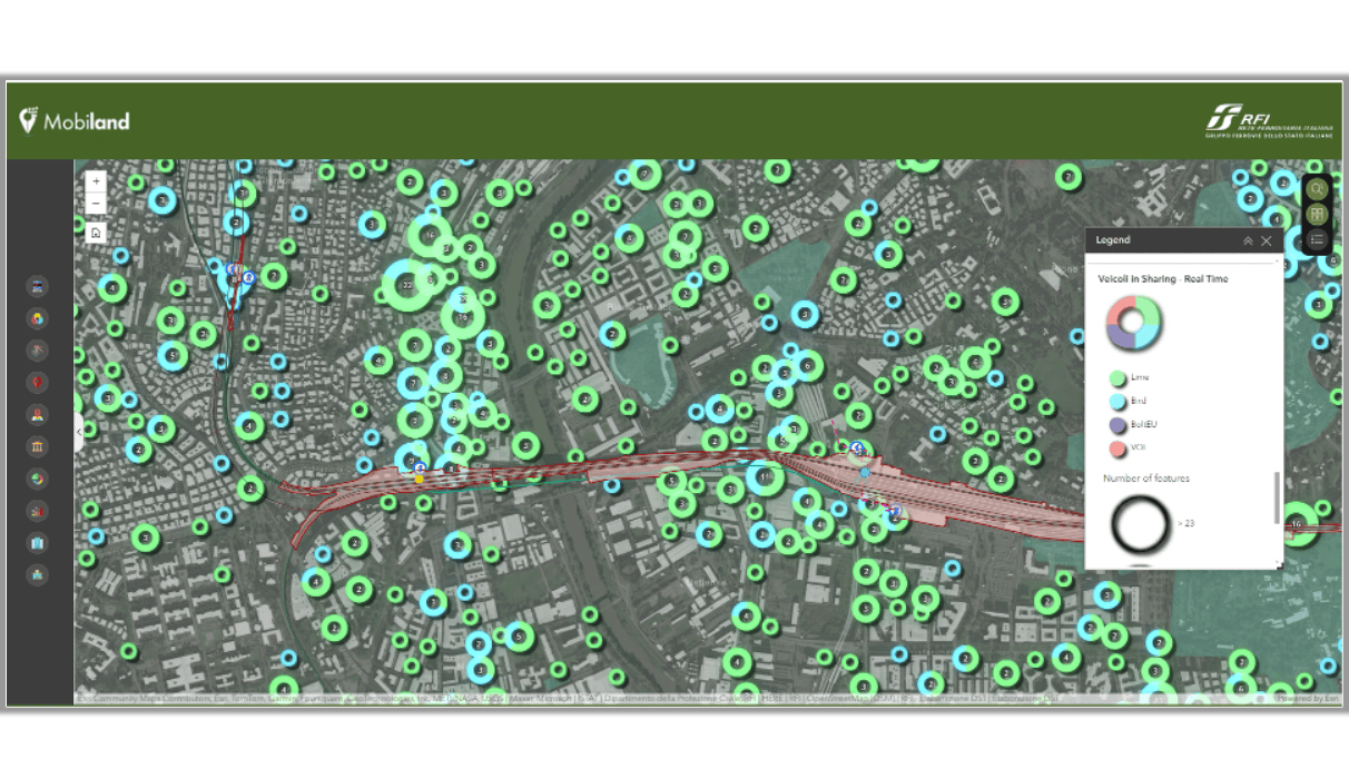
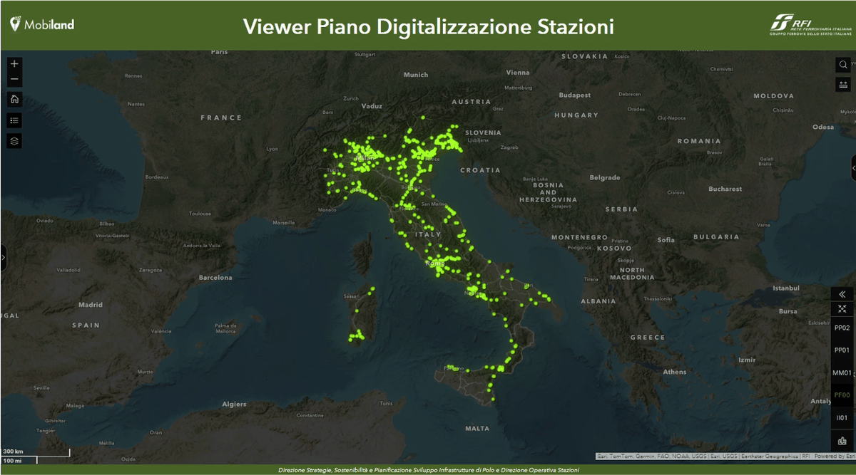
But they could see them on their map, a geographic information system (GIS) with 400 individual layers, from train lines to tree cover to taxi stands to demographic data. “We know who lives in the area [and] works in the area, broken down by their type of job,” said Contestabile. Then there’s hospitals, schools, businesses of all kinds, museums, tourist destinations, trade fairs, stadiums, parks, UNESCO sites, and much more.”
This location-specific analysis helped planners make the argument to rail leaders and city authorities for taking on the challenging proposition of digging under ancient streets to build a tunnel, opening up the station to the south. “If we hadn’t had this way of looking at the city, we would have never made that underpass,” Contestabile said.
The refurbishments—part of an ambitious, multibillion-euro upgrade to Italy’s rail system—also signaled a new way of looking at the entire railway: using maps and analysis from GIS technology.
Central to RFI’s efforts is the conviction that a rail station isn’t just a place to catch a train, but should be a vibrant hub of economic and civic activity, carefully integrated into their surroundings.
“For decades, rail infrastructure managers have focused their attention on the tracks, leaving the stations in the shadows,” Contestabile said. “And what was happening outside the stations seemed to concern us only in part.”
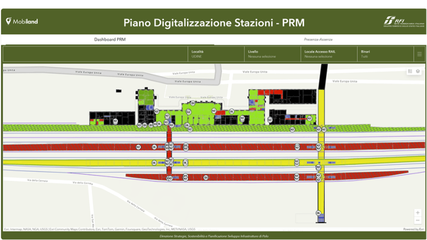
But better mapping and location data have changed that way of thinking. The planning team at RFI developed an advanced mapping and analytics platform known as MobiLAND. The goal as Contestabile put it, was to “understand how important the needs of the local community are to develop a better rail system.”
The area around the station appears as a series of small interlocking hexagons, each containing information about the likely density of people in any given area and other demographic data.
“For each of these points, we can use our algorithm to simulate a specific type of passenger as they flow throughout the city, and all the variables that might influence their movement,” said Giulio Lascialfari, who leads RFI’s location intelligence team.
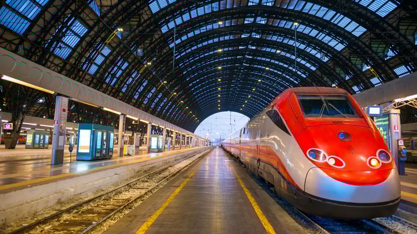
These data-rich insights are critical as the rail company pursues an ambitious expansion and redevelopment plan—part of one of the largest infrastructure projects in Europe, a multiyear bid by the Italian government to fuel economic growth through its century-old railway. The project includes renovations of some 600 stations and the construction of dozens more along a new high-speed rail network in the historically underdeveloped south.
“Every city has its own needs, and every city deserves its own solutions,” he said, “but everywhere, a well-developed train station boosts the economy and improves the livability of the surrounding areas.”
RFI’s Integrated Station Plan is transforming hundreds of the country’s railway stations from mere transportation nodes into what Contestabile calls “gravitational centers” for local communities and economies.
Along with adding accessibility features like ramps and elevators, the upgrades are transforming disused spaces in stations into cafés, shops, and social services offices aimed at meeting specific local community needs. By helping RFI planners better understand each station’s surroundings, MobiLAND is supporting those refurbishments.
For instance, a station close to a university would be the right place for low-cost cafés or study spaces; a station close to a big museum or a tourist attraction might call for an information booth, a luggage storage room, and a gift shop. In towns with fewer than 15,000 residents, station upgrades will include not only community hubs and coworking spaces, but also essential services like pharmacies and health clinics.
MobiLAND is also helping turn over empty station buildings across the country to local governments, community groups, and nonprofits. In the Alpine town of Rovereto, the empty main building of the railway station and the surrounding land are being transformed into a public civic hub focused on climate change, biodiversity, and heritage regeneration.
The idea of developing a GIS platform began in 2020 in the RFI Stations Department, sparked by a basic recognition, said Contestabile: “If we really wanted to understand how a railway station should work, we would necessarily have to understand the needs of the territorial context that hosts it.” A small team soon built several GIS tools and databases to support decisions and investments.
“We had technical challenges in the beginning, but the greatest challenge was cultural,” he said.
Within a few years Contestabile’s group moved to the RFI’s Sustainability and Planning Strategies Directorate. With help from an interdisciplinary GIS melting pot—light on engineers but rich in architects, urban planners, mathematicians, remote sensing experts, and physicists—the work evolved to encompass not only stations and their surroundings but the entire Italian mobility system: over 18,000 kilometers of railway lines and thousands of buildings, level crossings, tunnels, and bridges.
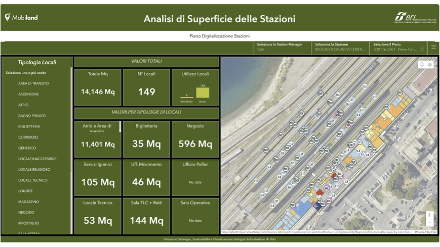
For any given station, Contestabile’s analysts can see over 400 data layers of environmental, mobility, economic, and sociodemographic details. On the map, they can see everything from tree cover and taxi stands to EV charging stations, crime statistics, and even the anonymized movements of cars and e-scooters in sharing systems.
On a collective dashboard, station managers can see detailed views of their stations. Planners across the whole network use MobiLAND to model renovation scenarios, share information with decision-makers and stakeholders, and guide billions of euros in investments.
For instance, by combining population density and types of populations—like students or white-collar workers—planners can predict transit demand and model the flow of commuters. Using that knowledge, along with factors like the slope of the terrain, can optimize bicycle parking lot designs or inform the expansion of mobility assistance programs.
Along the Adriatic coast, in Pesaro, RFI’s designers have ordered renovations that aim to integrate two neighborhoods currently divided by the station’s bundle of railway tracks. The main building, underpass, and platforms will be upgraded with more community functions, while the outdoor areas will be enhanced to support better access and improved safety, livability, and attractiveness.
At the Cattolica railway station, just 10 minutes north of Pesaro, RFI informed decisions about new amenities for pedestrians, along with an improved connection to the city park and more green space, irrigated by a rainwater storage tank system. The Institute for Sustainable Infrastructure recognized both stations with Envision Silver Awards, stating that they incorporated “historical, environmental, social, and economic sustainability throughout the planning, design, and implementation of these renovation projects.”
RFI is unlocking development funds outside the stations too.
In Lombardy, RFI used MobiLAND maps and analysis to spur the regional government to invest €41 million in redesigning the city squares in front of railway stations to favor pedestrians, bicycles, and public transport. After RFI demonstrated student demand, the ministry of transport ordered the construction of a new, €150-million network of bike lanes connecting about 50 of the country’s universities directly to stations.
“The new digital view enables a long series of innovations that is unprecedented,” said Pier Paolo Olla, RFI’s director of station operations. He sees more mundane breakthroughs on the way too.
“It will be possible to better manage cleaning by knowing every single square meter of the surfaces open to the public,” he said. “We are talking about 6 million square meters of walkways and 1.7 million square meters of buildings for travelers.”
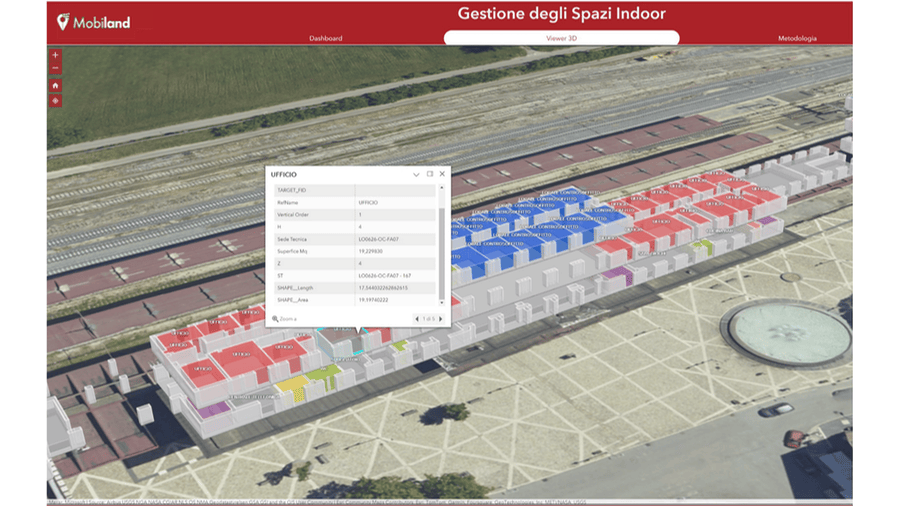
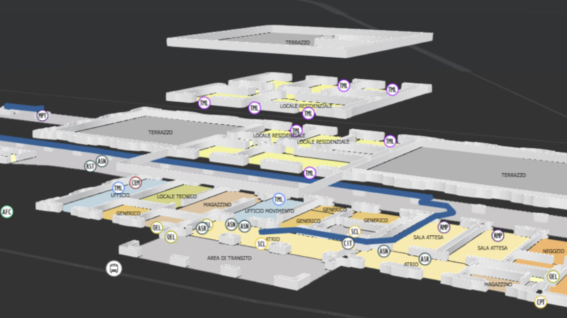
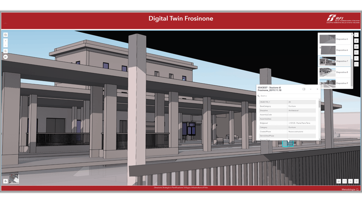
As Contestabile’s team members bring more stations into the system, they’re gaining visibility indoors too. Detailed digital models and digital twins of station interiors allow RFI to test scenarios and anticipate challenges in 3D before significant infrastructure investments are made.
By integrating building information modeling (BIM) with GIS, decisions about each station’s interior can be more directly informed by its surroundings. This integration allows planners to see how a proposed station entrance might affect pedestrian flow or impact environmental features. Whether designing for the dense urban fabric of Milan or the coastal geography of Naples, the approach ensures that stations are not just architectural landmarks but also thoughtfully integrated community anchors.
“The integration between BIM and GIS is essential,” said Marcella Faraone, head of the BIM and GIS department at FS.
To push the digitization forward, RFI has been investing in building its bench of GIS talent. More than 200 people have become specialists “who are now able to independently execute the entire digitization cycle of a station,” Olla said.
“We are completely internalizing these skills because we consider digital station management as an integral part of the company’s core business,” he said.
The approach fits Contestabile’s vision: “connecting stations with the soul of the city.”
The result is a new generation of Italian rail stations that are technically sophisticated, environmentally responsible, and deeply responsive to the people they serve.
“In Italy, they live in osmosis together,” Contestabile said of stations and their surroundings. “You can’t make a station work if you don’t understand what’s outside of it.”
Learn more about how GIS helps transform the way we plan, design, build and operate infrastructure.