Student-Led Mapping Locates Areas in Los Angeles in Need of Shade Equity
By Dr. Dawn Wright
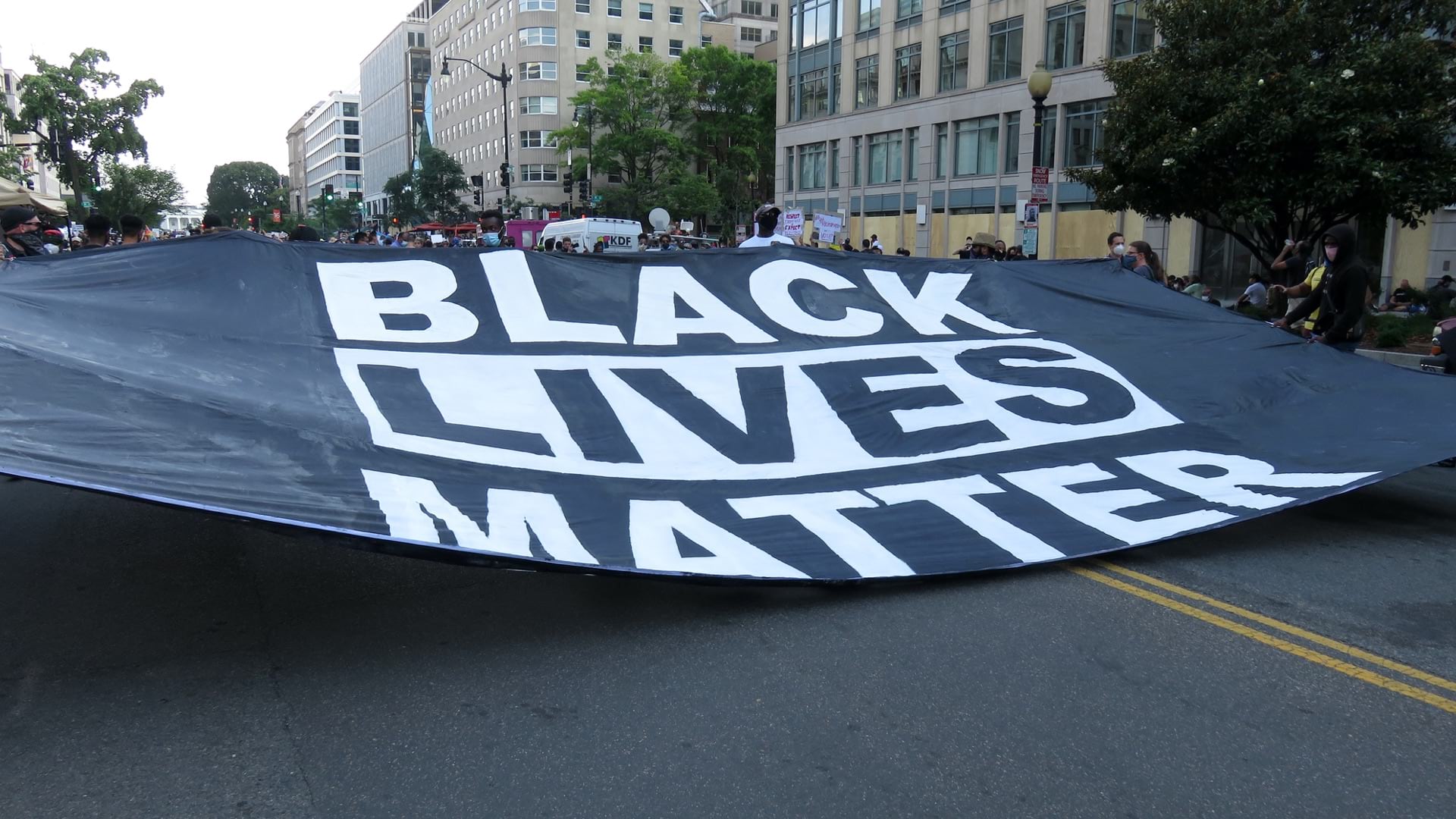
Like many US cities, Los Angeles is fighting to overcome the damaging legacy left by redlining. The practice, outlining areas with communities of color in red on maps to discourage mortgage lenders and insurance companies, was banned 50 years ago but the economic and racial segregation created by this practice persists to this day. In LA, historic redlining even affects the number of trees and resultant shade in neighborhoods, which comes with serious consequences.
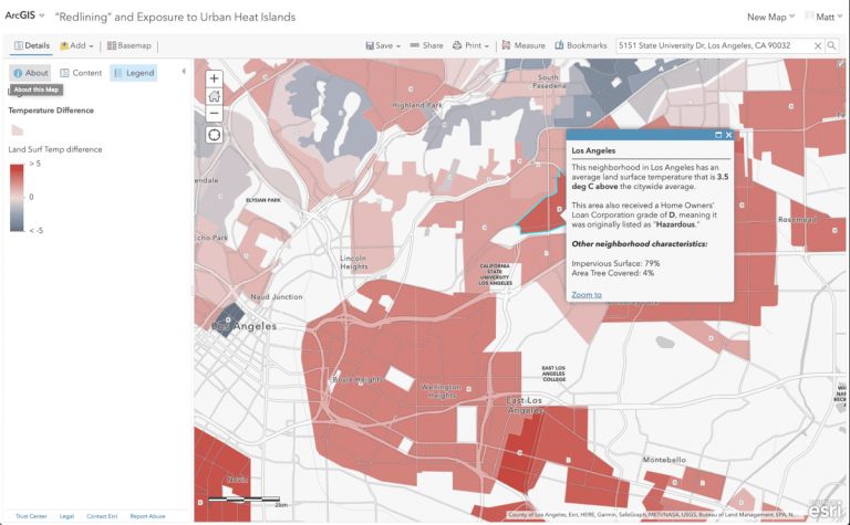
Recent research links redlining to lack of shade, contributing to dangerous urban heat islands. Previously redlined areas are on average 5 degrees warmer than others nationally and up to 12.5 degrees warmer in some places.
Extreme heat is the top summertime killer, particularly for the elderly, and also worsens preexisting conditions such as asthma and cardiovascular disease. This is all the more concerning as COVID-19 afflicts these vulnerable neighborhoods with higher rates of death than historically favored neighborhoods.
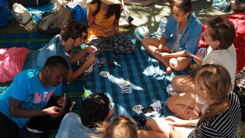
With climate change expected to exacerbate heat islands and health threats, Los Angeles leaders, community groups, and educators are teaming up to address urban tree cover with a sense of urgency. Planting more trees can help lower pollution, temperatures, stress levels, and energy bills of residents. Trees also improve aesthetics, clean the air and water, and even increase business revenue, while alleviating mental health concerns.
To effect real change quickly, a partnership between the City of LA, California State University Los Angeles (Cal State LA), and local nonprofits is using data and geography to maximize impact.
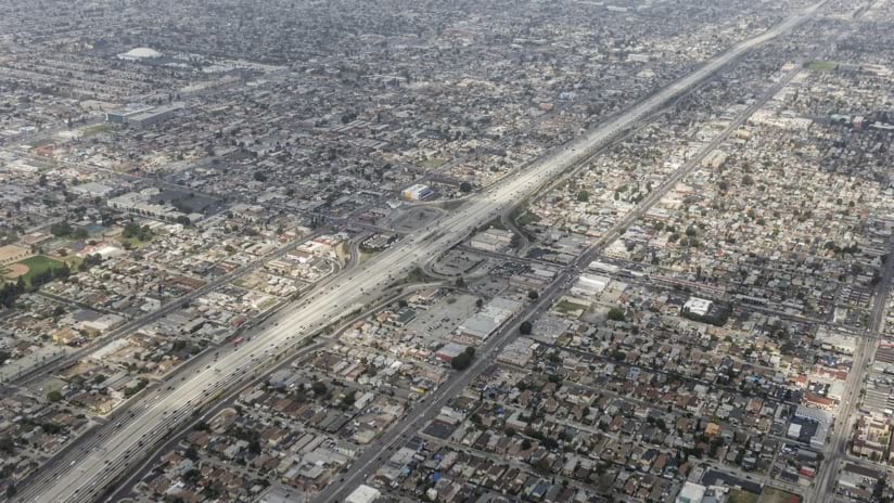
An aerial view of the Harbor 110 Freeway and dense communities in South Central Los Angeles shows a lack of foliage.
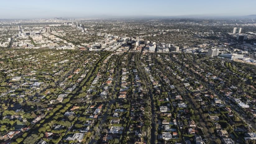
Dense tree cover in Beverly Hills contrasts starkly with less privileged areas of Los Angeles.
Geospatial Data to Advance Equity
As the largest city in California and home to nearly four million people, LA has a lot of data. Making that data useful is difficult, especially when information is trapped in spreadsheets and siloed by individual city departments.
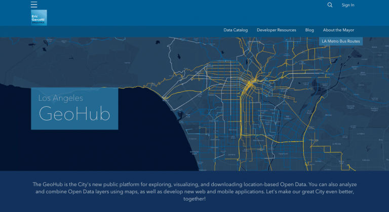
In 2016, Mayor Eric Garcetti launched a central online location to bring all city data together, with the goal of making better decisions. Dubbed the Los Angeles GeoHub, it combines information from many sources, from the fire department to utilities to the school district.
The LA GeoHub is built with ArcGIS Hub, a platform that facilitates community engagement around data and initiatives. Covering a broad spectrum of information from around the city, the data is open and accessible for anyone to use, map, and explore. Visualizing and mapping city data can help residents better understand their city and assist leaders in making improvements.
Alfredo Estrada, a Cal State LA student intern in Los Angeles who is learning how to use data to solve equity issues, explains: “I was addressing an environmental issue, working in Excel making graphs, and I really liked how my graphs looked. But as soon as I started working on the map, everything kind of popped. As evident as the issue already was to me, because I curated the data and graphed it, it’s just volumes more evident when you put it on a map.”
Helping Nonprofits Do Their Work
Nonprofit organizations are already hard at work in Los Angeles, laboring to address inequities. They often confront challenges such as low staffing, tight budgets, and not enough hours in the day. For these committed changemakers, efficiency is necessary. Though data is one of a nonprofit’s best assets, often they don’t have the time, budget, or capacity to make use of it.
“Many nonprofits may not have the infrastructure of having a research and development team,” said Preston Mills, community data manager for the City of LA. “They may not have the capacity to take a step away from, for example, providing meals to their homeless constituents to do an analysis of that work, because the work itself necessitates a level of detail and intentionality.”
This is why partnership with academia, business, and government is essential. Nonprofits need access to data, such as what’s available in LA’s GeoHub, and also help from people who know how to use it.
This grant is an amazing opportunity for us to not only showcase the fact that data can be used to first strengthen and improve our communities but also just empower one another to say we can make our communities better and we deserve to make our communities better.
Community Data Manager, City of LA
Preston Mills
Planting Seeds in Academia
In 2018, the National Science Foundation (NSF) awarded a $1 million grant to California State University, Los Angeles, funding a three-year collaboration with the City of LA to train students in big data and help nonprofits use geographic data. Students are trained in using a geographic information system (GIS) to apply data to solving problems in the community. Along with basic data science and GIS training, students also learn to use LA’s GeoHub.
Mills was hired as part of the grant to support Cal State LA scholars, faculty, and graduate students, helping with training and assistance. In classes on GIS and data science, he observed students realizing how they could use data to advocate for their communities. One day in class, Mills showed the students a map of Los Angeles with areas affected by environmental concerns highlighted in red.
“A lot of the students actually lived in communities where that dark red was showing, which essentially indicated that these students were living in places that have been correlated with some of the most concerning risks related to environmental health and individual health,” Mills said.
Once the students knew they lived in at-risk areas, they had a choice to make: ignore the problem, move somewhere else, or become advocates. “In that moment,” Mills said, “it was really clear to me that this grant is an amazing opportunity for us to not only showcase the fact that data can be used to first strengthen and improve our communities but also just empower one another to say we can make our communities better and we deserve to make our communities better.”
After participating in the data and GIS classes, a number of students, known as Social Equity Engagement geo-Data Scholars (SEEDS), are selected for paid internships with local nonprofits over the summer months.
Dr. Pamela Scott-Johnson, dean of the College of Natural and Social Sciences at Cal State LA, said, “We labeled it SEEDS because we wanted to plant new ideas and ways of being for our students, city, and the nonprofits. We help them start to grow the seed of having people be more data oriented in the management of their projects.”
The Cal State LA SEEDS scholars embed themselves in local nonprofits and employ their learning to a real-world problem, like shade equity in LA. In 2019, the SEEDS program culminated with 12 project-based paid internships at local nonprofits, also funded by the NSF grant.
With the help of Community Partners, an organization that provides support and resources to over 200 LA nonprofit organizations, SEEDS scholars are matched to nonprofits with a particular need.
“Education should be designed to make a difference for the individual and the community that they come from, in addition to elevating the thinking and approach that people have,” Scott-Johnson said. “And the social justice piece is the individual’s growth in context with the communities that they either come from or that they will choose to serve.”
Estrada was one of those SEEDS scholars, and he decided to work with a nonprofit called City Plants to address LA’s tree canopy equity.
Greening the City, with Data
City Plants, a nonprofit public-private partnership with the City of LA, is funded through the Department of Water and Power. Its mission is to create an equitable urban forest for all Angelenos. Its leaders point to research from the LA Urban Cooling Collaborative that directly ties increased forest canopy to lives saved, especially in low-income communities and communities of color.
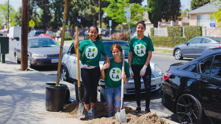
Volunteers pitch in to beautify, and cool down, their neighborhood. (Image courtesy of City Plants)
City Plants program director Rachel O’Leary believes, “City Plants is at the intersection of a lot of equity and social justice work—trying to take relevant data, relevant research, and weave it together to help inform urban forestry equity priorities in the city while also making sure to center the voices of the communities that we work with in that effort.”
In 2019, City Plants had compiled data chronicling where they planted trees, what types, and who the recipients were. All that data lived in spreadsheets where it was difficult to access and put to use. That’s where Estrada’s internship came in—he cleaned and organized the data into a GIS where it could be mapped, analyzed, and visualized. He built out a data infrastructure for City Plants, so data could continue to be organized, accessible, and useful long after his internship ended.
“They had five years’ worth of data, about 30,000 records of trees and addresses. I had to figure out a way to make that usable,” Estrada explained. “Using maps is a great way to visualize the impact of a nonprofit. And my nonprofit is dedicated to planting trees, so I wanted to take all the data that they had on all the trees planted and put those points on a map.”
Visualizing the data helped O’Leary and the City Plants team better understand trends in their program, such as where they deliver the most trees, and focus their efforts, highlighting areas with room to grow.
“City Plants is up to big things, and we only have a staff of three. Having a SEEDS scholar on our team was incredible,” O’Leary said. “He not only centralized the data and standardized it, he also gave us tools to continue what he had worked on.”
The nonprofit was able to share its maps of trees planted with the program funder and partners and city officials to “celebrate the impact of our work in urban forestry and also show where we have more work to do,” O’Leary said.
The team experienced another unexpected benefit to organizing its geospatial data—easily accessible records of constituents served, mapped by location: an instant customer management system.
Partnering to Create Real Change
Real change and momentum are happening in Los Angeles as a result of partnerships, collaboration, and open data.
Mayor Garcetti recently appointed the city’s first City Forest Officer, Rachel Malarich, formerly of another nonprofit, Tree People. The mayor also committed the city to plant 90,000 new trees by 2021 and increase tree canopy in some areas by 50 percent by 2028 as part of LA’s Green New Deal. A champion for a data-driven approach to urban canopies, Malarich will collaborate with Davey, StreetsLA, the Department of Recreation and Parks, and City Plants to conduct the city’s first fully-integrated public tree inventory to improve data, track trends, and inform urban forest management policies and best practices for the future. To date, over 168,000 street trees and 94,000 park trees have been inventoried.
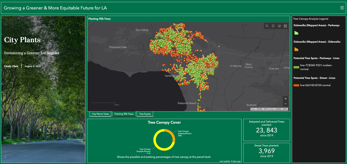
City Plants hosted a second SEED Scholar this summer to build upon Estrada’s efforts. Cindy Chen, a masters candidate studying Environmental Science at Cal State LA, created an interactive dashboard and map to showcase City Plants’ efforts and help track tree canopy goals in Mayor Garcetti’s Green New Deal. Chen picked up where Estrada left off, mapping trees planted through the City Plants program. She also spent the summer mapping viable locations for tree planting along residential neighborhoods in low-canopy regions of the city, a critical step in reaching the canopy equity goal in the Green New Deal. City Plants plans to conduct targeted outreach and community engagement in the areas Chen helped define.
The new City Plants dashboard helps monitor the equity goal in LA's Green New Deal.
Spatial analysis of City Plants prior efforts are helping the non-profit plan future planting.
Another grant is funding renowned tree canopy expert Vivek Shandas as a visiting scholar. He will use GIS data to determine where best to expand tree canopy in low-income, heat-impacted areas, focusing specifically on equity.
“Tree planting in Los Angeles is a hugely collaborative effort,” O’Leary said. “I think it’s one of the most exciting times to be doing this work. And I think it’s timely. When we talk about building resilient communities, trees are a part of that equation. They are not a silver bullet solution, but they are definitely one step we can take to building a more equitable, climate-resilient future for Angelenos.”
SEEDS scholars have also made an impact in other social justice projects. For example, SEEDS scholar Takouhi Tarkhanyan worked with the Los Angeles Regional Reentry Partnership (LARRP) to create an interactive map of resources like housing, education, and mental health for formerly incarcerated people to help ease their transitions. She transformed what was a text document into a vibrant and instantly helpful resource. Her work directly led to a further $175,000 in funding for LARRP. Many other student projects are also in the works.
This is the second year of the NSF-funded partnership, and all SEEDS internships will now have to be virtual due to COVID-19. But since the groundwork was laid in 2019, the program is on strong footing to continue with more training and internship projects.
Collaboration Key to Success
In this story, the partnership between academia, government, and nonprofits sparked quick progress. NSF providing grant money. The City of LA offering staff support and open data through its GeoHub. Cal State LA’s administration orchestrating the program, and the faculty training students in data literacy. Community Partners connecting students and organizations that needed help with big data. Nonprofits doing the hard work to transform Los Angeles, alongside engaged residents who donate and volunteer. The students themselves diving in, caring, applying data science, and giving back to their communities.
“We’ve been able to increase the efficacy of our training programs, our partnerships, and how the city sees what it does in the community,” Scott-Johnson said. “Most importantly, we have created cultural relevancy in the way that students use their classroom activities and their learning to make a difference for their community.”
A greener LA is already taking shape due to this collaboration. Leaders of the SEEDS program, City Plants, and the City of LA hope others will be inspired and take action to unite open data, community groups, academia, and government to work toward a more equitable future.
To learn how governments, nonprofits, and businesses can address racial inequity, visit Esri’s website on Racial Equity. Explore deeper GIS resources for racial equity on the Racial Equity GIS Hub, including a dataset on redlining and exposure to urban heat islands. View free resources on Urban Tree Canopy from the Esri Press book, GIS for Science.
Share this article:
Equity & Social JusticeSpatial Analysisequityopen dataspatial analyticsstudents
Dr. Dawn Wright
Dawn Wright is Chief Scientist of Esri. She works to strengthen the scientific foundation for the company’s products and services. Notably, Dawn led the team that created the Ecological Marine Units (EMUs), a 3D digital ocean that creates better understanding of marine environments and how to plan for more sustainable activities there in the wake of climate change.
Dawn joined Esri in 2011, and has written and contributed to some of the most definitive literature on marine geographic information system (GIS) technology. An elected member of both the National Academy of Sciences and the National Academy of Engineering, as well as the American Academy of Arts & Sciences, she earned her doctorate in Physical Geography and Marine Geology from UC Santa Barbara. In 2022, Dawn became the first Black person to visit the Challenger Deep in the Pacific Ocean, the deepest and most unexplored place on planet Earth.