November 1, 2022 |
When the United Nations failed to agree on a plastic treaty in 2025, Carl Nettleton realized his work to protect the oceans mattered more than ever. As the founder of OpenOceans Global, he’s on a mission to stop ocean plastic at its source.
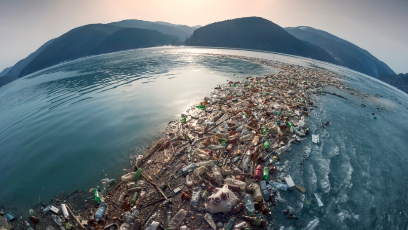
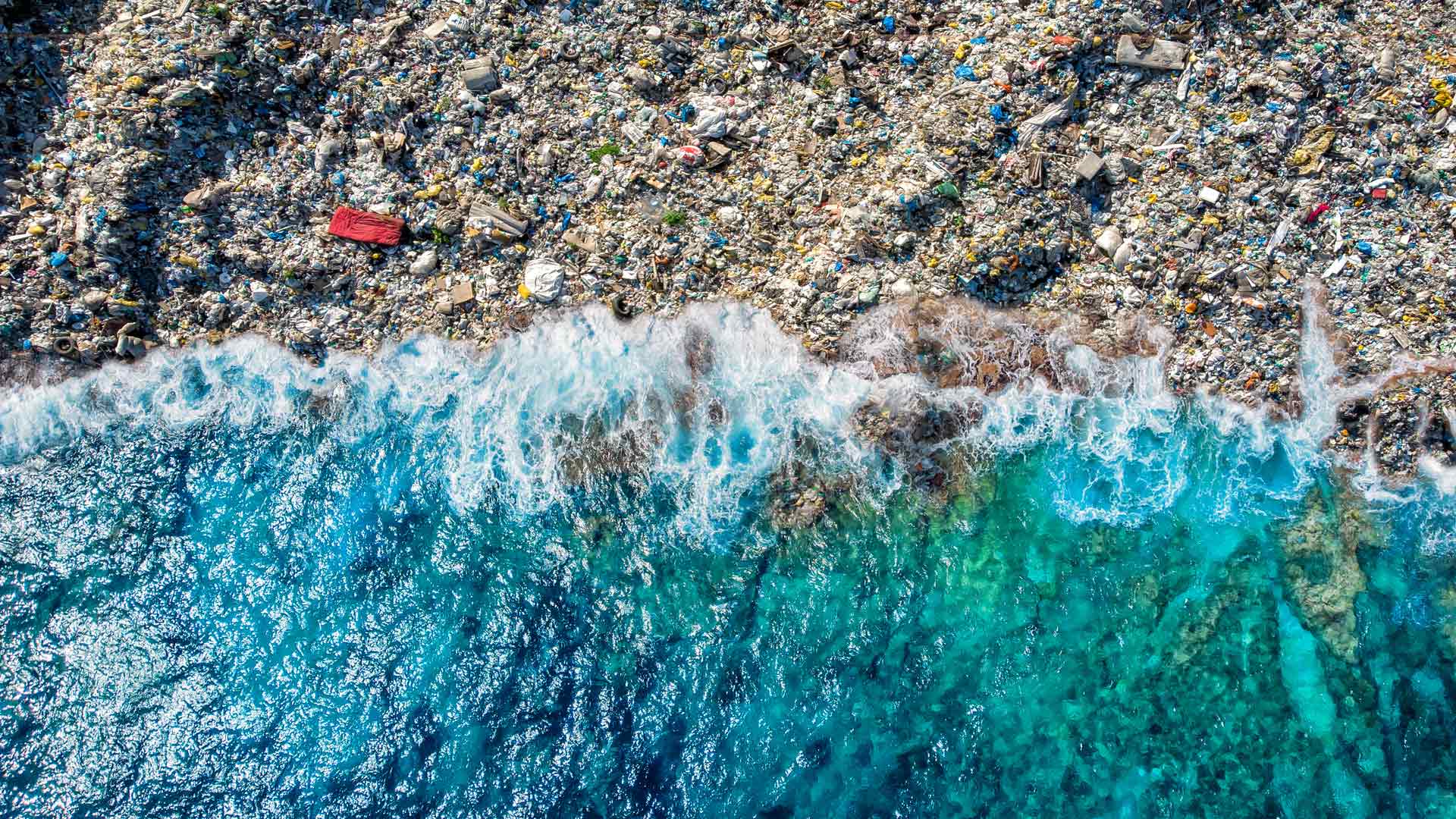
Global water systems absorb plastic pollution equal to 2,000 truckloads of garbage every day, according to UN studies. In fact, some local governments do dump truckloads of trash into rivers and other bodies of water, devastating ecosystems and damaging human health. The practice is often due to poor infrastructure, limited funding, and weak oversight. Without action, plastic production and waste could triple by 2040, warns Pew Charitable Trusts and SYSTEMIQ.
To drive change, Nettleton needed to know the origins of plastic pollution, since that would help unite people around solutions to address it. “I look at it like a viral outbreak,” he said. He even modeled a plastic pollution outbreak map after the Johns Hopkins University COVID-19 Map to show where action is most needed.

“If we can map and stop plastic at its source,” Nettleton said, “we wouldn’t need to clean up the beaches, coastal areas, and deep ocean after it disperses.”
Close to 80 percent of ocean plastic comes from rivers, as estimated by Netherlands-based nonprofit organization The Ocean Cleanup. Less understood are the pathways through which plastic moves into oceans.
OpenOceans Global was founded in 2007 with a goal of aggregating and visualizing the world’s ocean data. Recognizing the need to first succeed with a more focused effort, Nettleton began tracing land-to-sea pathways. Data was both the starting point and the obstacle. Much of the insight he needed either didn’t exist yet or was fragmented across multiple sources.
Over time, he combined scattered data, filled gaps with his own research, and anchored it all in maps made with geographic information system (GIS) technology. Nettleton created mapping apps with GIS, such as the Ocean Plastic Map, which uses ArcGIS Survey123 to collect data from people who witness pollution in coastal areas.

These types of maps bridge global policy and local action.
Nettleton has been an active participant in UN plastic treaty talks since they began in 2022. These efforts can take 20 or more years to complete, however, so he also collaborates with local communities to drive immediate action.
Now, Nettleton expresses urgency: “An international treaty, even if agreed upon and ratified, will not be effective for decades, and we have to act now,” he cautioned.
Maps of water systems and pollution data are being used to create a more foundational intervention. They are helping OpenOceans Global create a working model that can be replicated anywhere in the world to keep plastics from reaching the ocean.
Using maps that show regional plastic pathways, Nettleton’s team built a prototype GIS dashboard. It combines data, visual tools, and predictive models to help stop pollution upstream. Called the Ocean Plastic Pathways (OPP) initiative, the prototype is being piloted in Ecuador, where GEO Tierra Ecuador—part of the Group on Earth Observations (GEO)— adopted it as its national project in 2025.
“It’s a collaboration on impressive scale,” Nettleton noted. Coordinated with Ecuador’s Instituto Geográfico Military in conjunction with La Escuela Superior Politécnica del Litoral, it involves GIS experts from Esri, federal agencies, research universities, and regional NGOs.
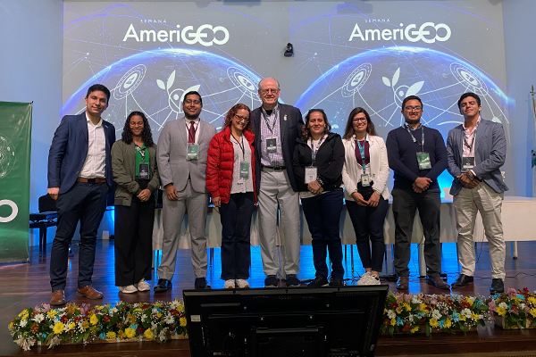
To kick off the pilot, the multi-agency team hosted expert-led workshops for participants from Ecuador, Trinidad and Tobago, Colombia, and other countries in the region at AmeriGEO 2025. The event provided a forum for sharing research on ocean plastics and discussing ways to scale the project. A key principle of the pilot is to establish local ownership of mapping and intervention. This requires technical assistance, mentoring, and capacity building. Esri Ecuador and Esri Colombia are supporting the effort.
“What we’re learning from Ecuador is if it’s a local problem, the local folks probably know where it is,” Nettleton said. “And if we can provide the tools to put what they know on a map, we can inform leaders of plastic origins so they can put policy, funding, and resources behind a solution.”
In a few short months, the Ecuador pilot team created detailed maps of local beaches, watersheds, and ocean currents. The maps give locals a bigger picture of what’s happening where. It’s clarity that connects solutions to the places they’re needed most—in areas with high plastic emissions and in tourism centers.
After refining the dashboard through the Ecuador pilot, OpenOceans Global plans to expand it to regions with the worst plastic pollution. In a recent talk at the University of California San Diego, Nettleton shared data on the world’s top rivers carrying plastic to the ocean, highlighting where to focus solutions.
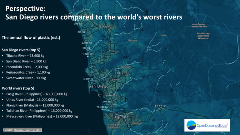
As much as 55 percent of ocean plastic reaches the ocean from five countries, according to a Florida State University study. That includes China, the Philippines, India, Brazil, and Indonesia. The Philippines, the largest source of river-contributed plastic, presents a unique opportunity.
“Imagine an international effort focused on the Philippines in a positive way,” Nettleton said. “Not to blame anyone, but to help solve the problem.”
He imagines the Philippines as a zero-ocean-plastic nation. And then, what is learned could be applied to the next top pollution hot spots.
Despite progress, OpenOceans Global still faces challenges with data accuracy, especially since some valuable datasets are no longer publicly available or regularly updated. But GIS is catching mistakes automatically, like spell-check for maps. It flags missing or incorrect information so the team can fix it. Authoritative basemaps, demographics, and content from Esri—curated from vetted sources and evaluated for quality—help fill data gaps.
Another approach involves engaging university groups, NGOs, and volunteers in data collection and mapping to enhance the Ocean Plastic Map. Nettleton envisions something like NASA’s citizen science program that’s had over two million participants and many significant new discoveries.
To bring it all together, the OpenOceans Global team is building a GIS hub for organizing people, data, projects, and tools in one place. The site will feature global best practices and targeted interventions to meet the unique needs of different areas. Local actions might include floating trash barriers, community cleanups, AI monitoring, or biodegradable innovations. The plan is to rate solutions by effectiveness and update them with feedback from the field.
With or without an international treaty to tackle plastic pollution, the OpenOceans Global OPP initiative with Ecuador holds great promise. Communities are beginning to see a path for cleaning up their regional waterways. Equally impactful as solving the problem is giving people the tools and confidence to take action where it matters most to them—both now and in the future.
“We can’t recycle our way out of this problem,” said Nettleton. “Even slowing plastic production today would require decades of pollution cleanup.” For communities like those along Ecuador’s rivers and beaches, the map isn’t a policy instrument—it’s changing what people believe they can achieve.
Learn more about how GIS is used to explore, map, visualize, analyze, and protect the ocean.