


April 23, 2024 |
Sunny Fleming | Conservation
Keegan Clifford had a simple goal: help grandparents find the right park to take their grandchildren. What he discovered instead was that his department’s 37, 000 acres of parkland weren’t actually accessible to everyone.
“I wanted that grandma to pull up a map on her phone or computer, find a park, and have no issues,” said Clifford who is the geographic information system (GIS) coordinator of Montgomery Parks in Maryland.
The Montgomery Parks Department works with the Maryland-National Capital Park and Planning Commission to manage parks across Montgomery County, just north of Washington, D.C. Making those parks genuinely accessible to everyone meant two major initiatives: overhauling the department’s Parks and Trails Atlas and revitalizing 10 neighborhood parks.
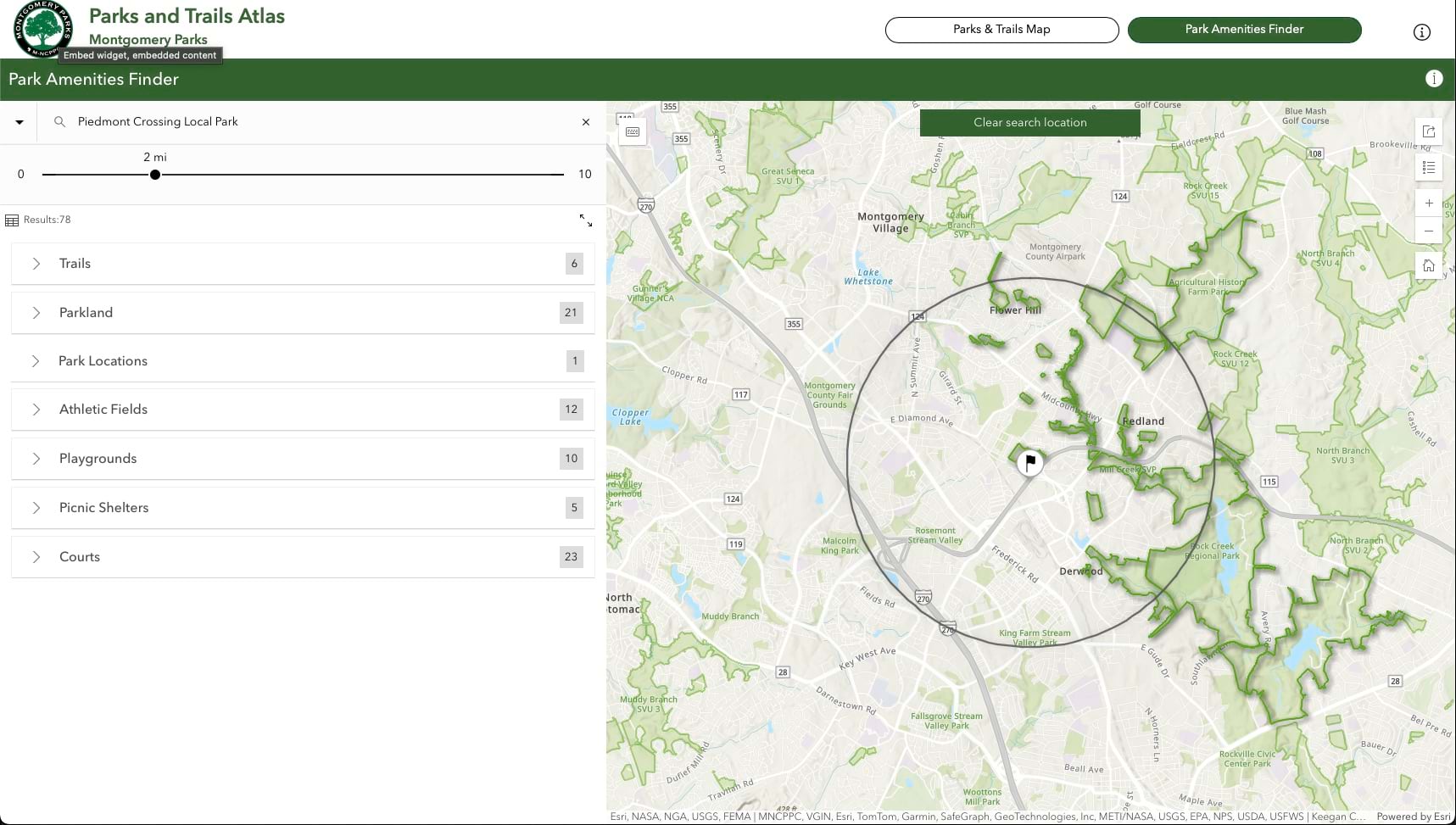
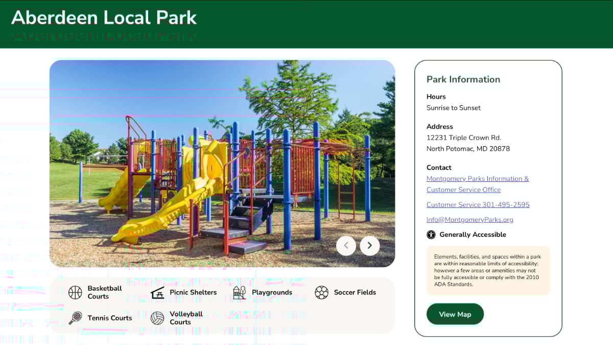
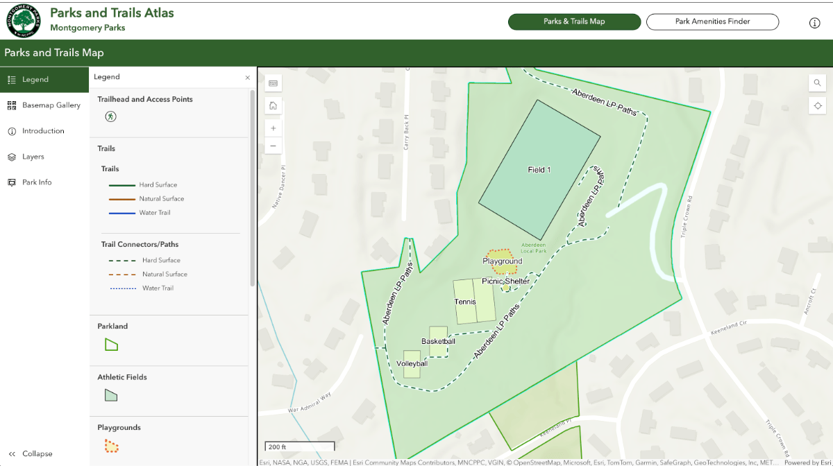
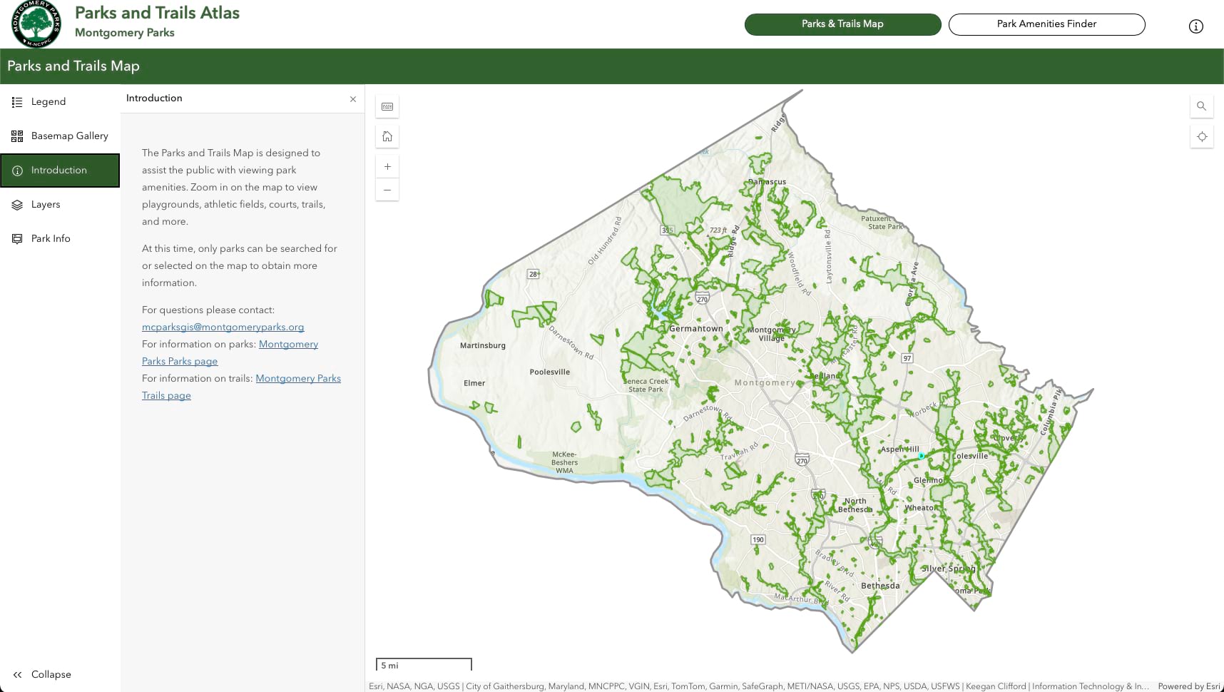
With the new Parks and Trails Atlas app, users can explore trails, fields, playgrounds, picnic shelters, and other amenities through an interactive map. Built with GIS technology, the app works on mobile devices and includes immersive imagery. Users can click on any location to jump directly to the Montgomery Parks website for details on available amenities. A park amenities finder lets users search by park name, address, or ZIP code.
Before launching the app, Clifford and his teammate Tiffany Wu did something unusual: they asked people with disabilities what they actually needed.
They sought input from the Commission on People with Disabilities and the National Federation of the Blind to understand the experience for visitors with limited vision or color blindness. One visitor recorded how they navigated the app using only their keyboard—no mouse. They watched them click through menus, listen to screen reader descriptions, and work around barriers that revealed exactly where improvements were needed.
“Seeing how they used our tool was what we needed,” Clifford said. “We learned that what seemed intuitive to us created roadblocks for others.”
The team now plans to add alt text for the app, along with assistive technology to help individuals with limited vision navigate. The team also plans to include detailed information about park amenities, including whether restrooms and parking spaces meet accessibility standards, so residents can plan visits with confidence.
“We’re seeing fewer questions, more people using the tools, and better feedback overall,” Clifford said. “It’s working, and that means more people are finding parks.”
Montgomery Parks has plans to revitalize 10 parks in a historically underserved community through the Long Branch Parks Initiative. The department gathered feedback from residents to guide its priorities and decisions, then used GIS to evaluate current conditions and plan upgrades.
Upgrades range from safety enhancements—like improved lighting—to amenities that encourage community gathering, including picnic areas, multipurpose fields, and renovated courts. Some parks are getting updated playgrounds, while others focus on environmental restoration, such as stream improvements and tree preservation.
A consistent theme across the initiative is connection. Staff are adding new bridges and trails to better link parks with nearby schools, libraries, and community centers—responding directly to residents’ desire for more integrated neighborhood planning.
In denser areas where land is limited and acquiring new property is difficult, the department is mapping where more compact amenities might fit, like paved surfaces that can accommodate futsal—a modified soccer sport played on a hard court. Planners are also exploring possible vertical solutions, such as building recreation spaces atop parking garages.
“If we can energize that space with a basketball court or a pavilion in one location instead of just parking, we’re serving the community in a whole new way,” said Carl Weber, athletic field planner at Montgomery Parks.

Planners are also considering how people travel. “In densely populated urban neighborhoods where residents are less car dependent, we explore opportunities to improve walkable access to athletic fields,” said Jing-Huei Huang, research and evaluation planner at Montgomery Parks. A recently proposed field near a light-rail station in the East Silver Spring neighborhood, for example, is designed to serve transit commuters and nearby walkable communities.
These strategies reflect both the need for more amenities and the reality that users may need different modes of travel to access them.
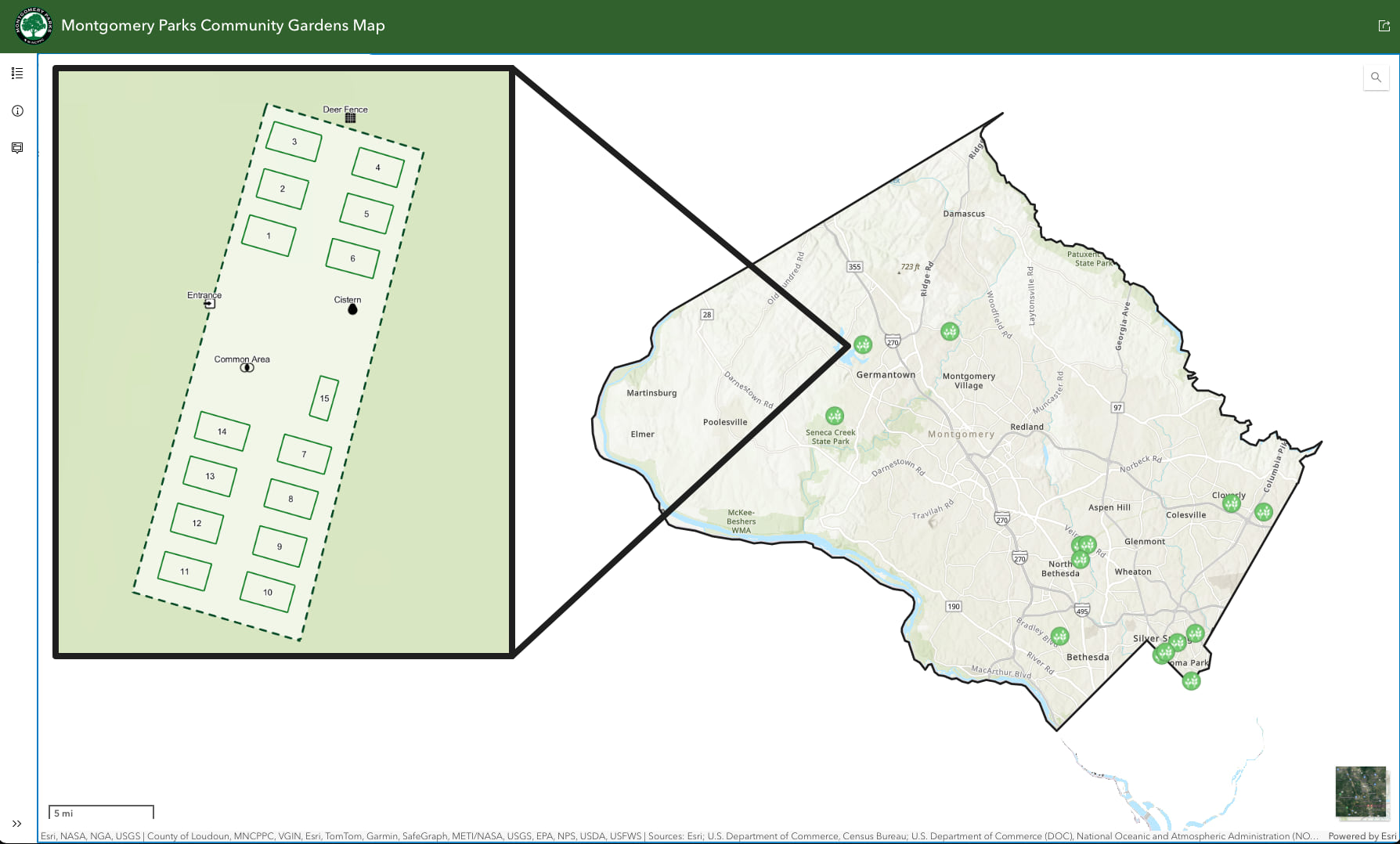
A similar analytical approach is applied to expanding the department’s community gardens program, which currently includes 14 gardens across the county. “We have a long wait list,” Huang said, adding that GIS analysis tools are helping identify new locations to meet demand and ensure that more residents have access to garden spaces.
Some of the analysis tools Huang and Weber rely on are the county’s Athletic Field Finder; Athletic Field Dashboard (an in-house GIS dashboard); and ArcGIS Pro, which brings together data from planning, permitting, and maintenance teams. These technologies also help the department see field locations, identify gaps, and analyze service areas.
While GIS technology helps Montgomery Parks understand where parks and amenities are needed, community input ensures that what’s built truly reflects what residents want. Staff host community meetings and conduct surveys. In the past they hired consultants to knock on doors to ask neighbors what they’d like to see in their local parks.
“We’ve handed out sticker sheets at community events and asked people to mark the amenities they’d like to see on a map,” Weber said. “We try to make sure their voice is heard.”
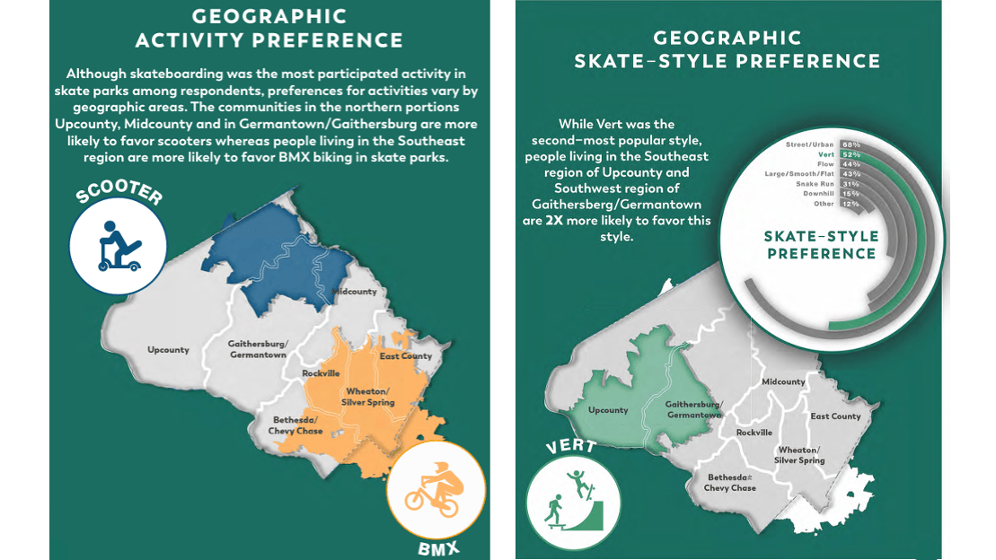
That outreach has led to real wins. A recent skate park initiative entailed surveying over 700 residents, revealing preferences by geography, age, and skill level. That feedback is shaping five new skate parks, each tailored to its community. Perhaps the most meaningful victory came from listening to Special Olympics athletes who had been using temporary bocce courts. Their advocacy convinced Montgomery Parks to seek out developing a permanent, Americans with Disabilities Act (ADA)-compliant location.
“We’re in the site selection phase now for a permanent bocce facility,” Weber explained. “The Special Olympics athletes who’ve been using temporary courts helped us understand what they need—not just a place to play, but a location that’s truly accessible and serves the community, long term.”

Today, that grandmother whom Clifford imagined can find exactly what she needs with a few taps on her phone. Residents can find and explore parks online, access them in person, and discover amenities that foster connection and well-being.
“We’re still learning,” Clifford said. “Every time we test a tool or talk to a new user, we discover something new. Engaging the community and being open to feedback is critical.”
This mindset is transforming Montgomery Parks. The mission is clear and simple: Ensure that every resident—regardless of age, ability, or ZIP code—can find their place in the parks.
Learn how communities use GIS to provide quality park and recreation experiences that benefit all residents.