January 12, 2023 |
Holly Tripp | Mapping
It isn’t rare for Tom Hebert to pick up his phone and hear, “I found a dinosaur. Can you come dig it up?”
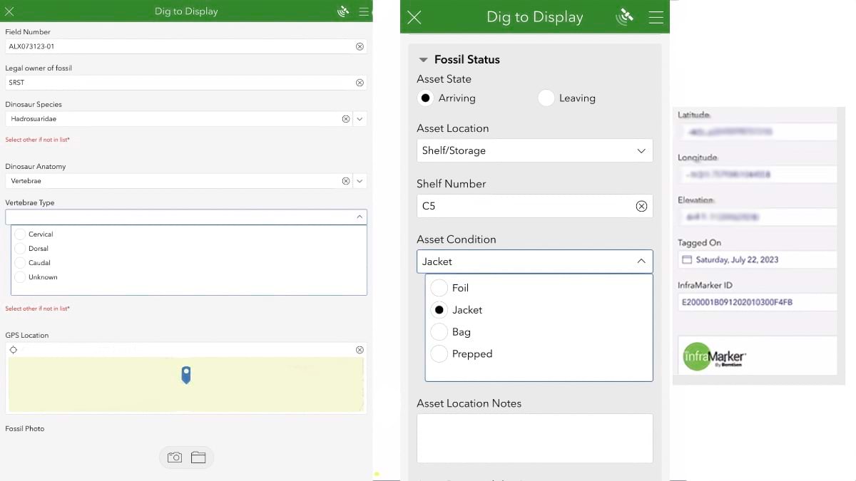
From his home in Wisconsin, Hebert has spent 14 years driving to and from dinosaur fossil-filled ranges in South Dakota, North Dakota, Montana, and Wyoming for digs. Lately, he has also been visiting museums to create a digital record of fossils on display or in storage. Hebert aims to transform the way museums manage fossils and other assets—using digital tools that include a location-aware data collection app, ArcGIS Survey123, and a radio-frequency identification (RFID) tracking technology called InfraMarker.
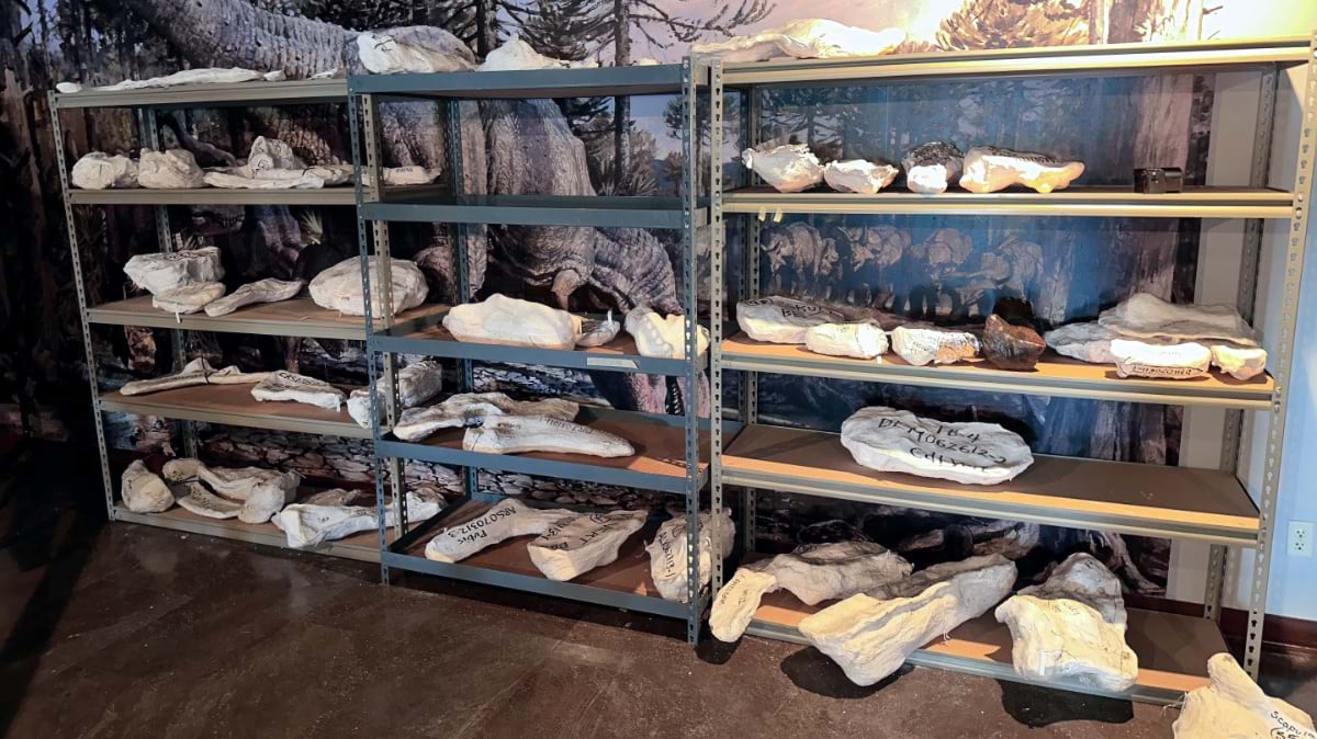
Often just a fraction of a museum’s collection is on display at any given time, with much more being stored on shelves and in drawers behind the scenes, including in off-site warehouses. The work of collecting, identifying, and displaying artifacts has long relied on handwritten notes and printed records. It’s no wonder then that keeping track of artifacts has been a challenge for even the largest museums, many of which have discovered pieces missing, damaged, or stolen during audits.
Researchers at the National Science Foundation, which funds the Integrated Digitized Biocollections site, and at the Smithsonian see the value in digitizing records. Doing so would make it easier to answer critical questions about our earth, including how surviving species recovered after the annihilation of the dinosaurs.
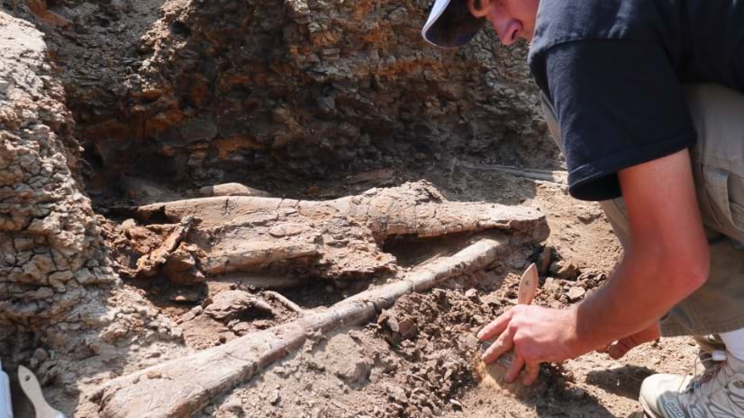
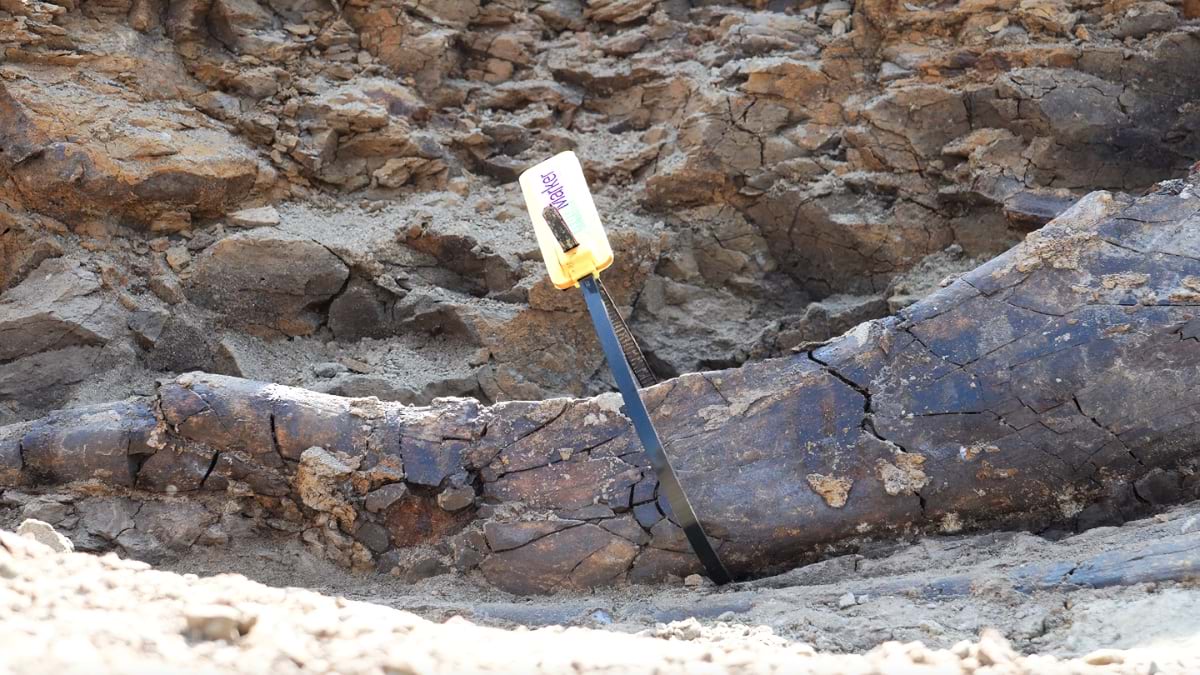
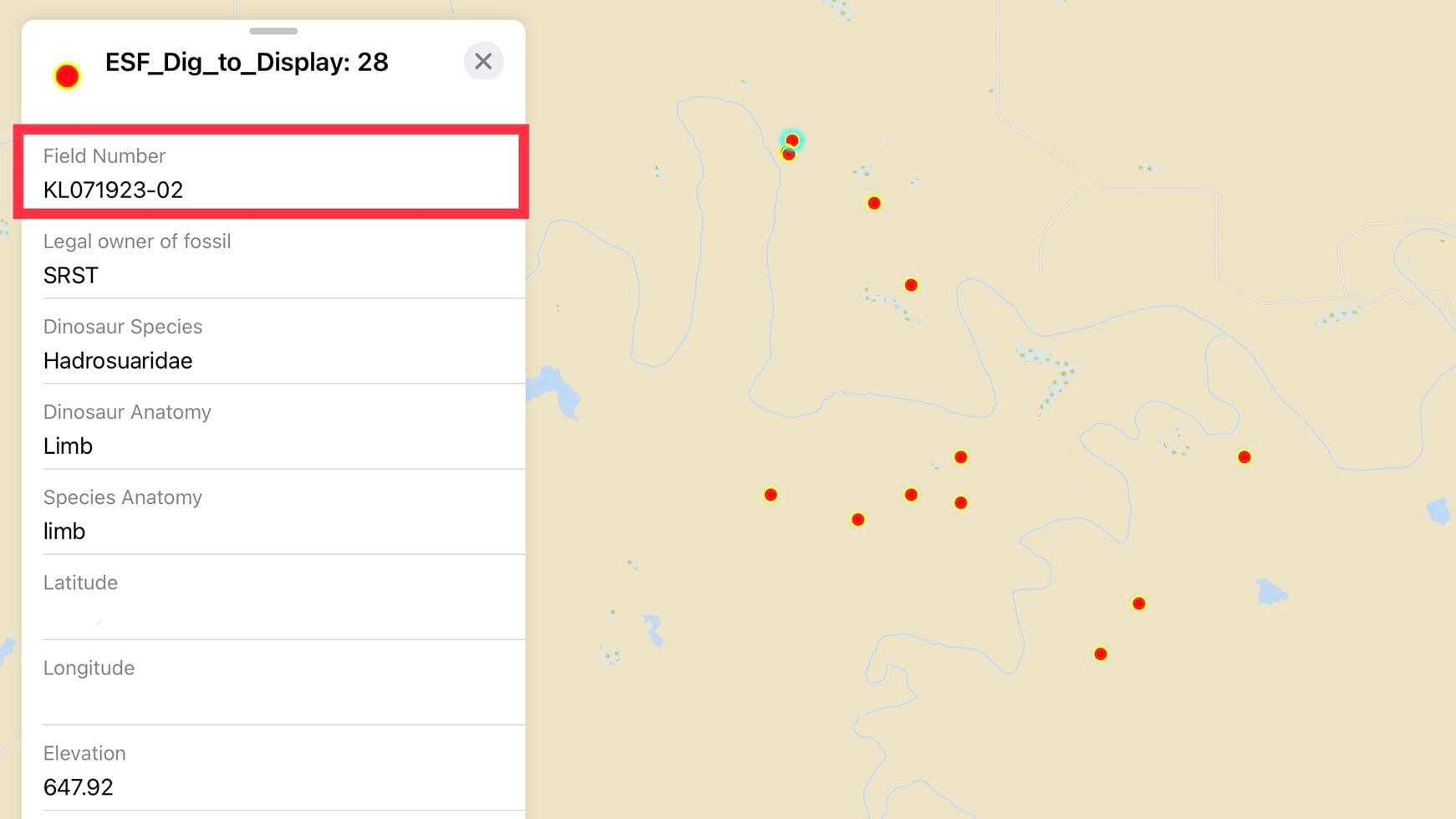
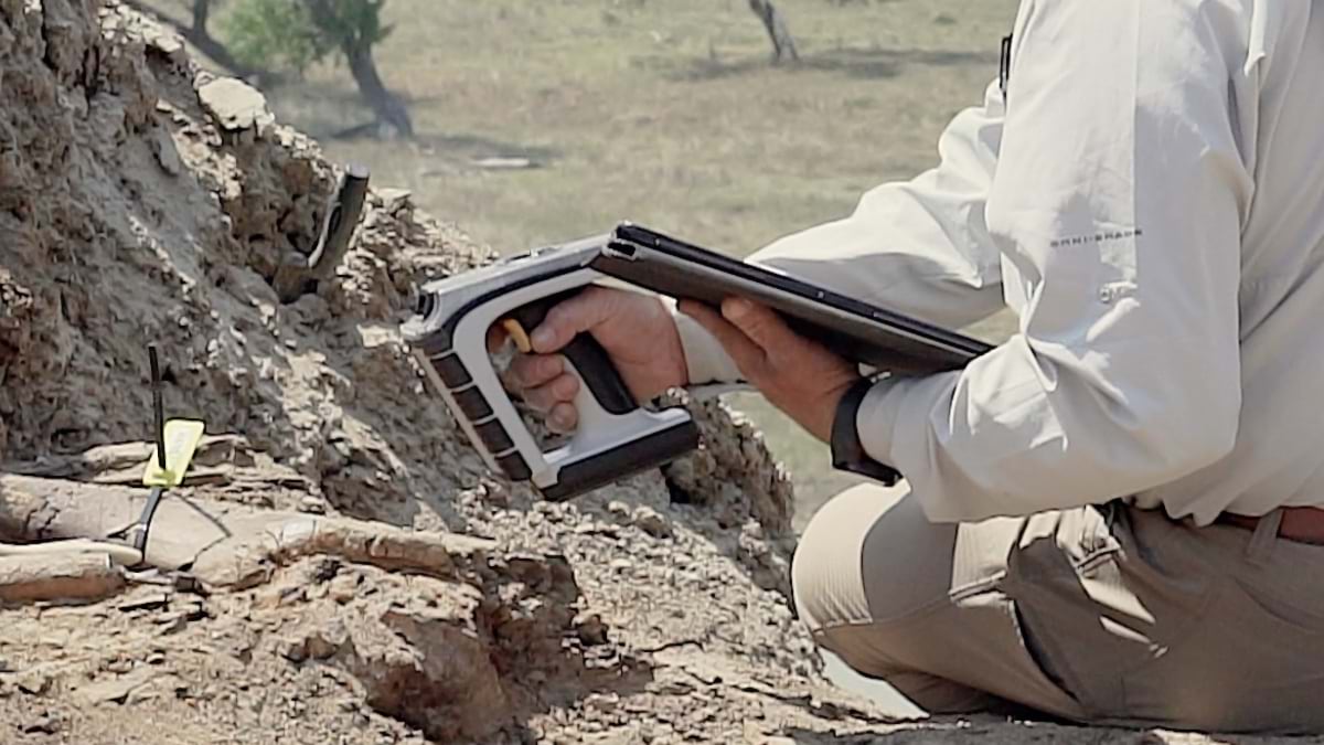
By attaching RFID tags to fossils, Hebert can track specimens from dig sites to warehouse shelves, to where they are cleaned and prepared and placed on display. This new awareness of fossil location, including near real-time tracking while fossils are in transit, provides a map-based audit trail that Hebert likes to call “dig to display.” It’s the first step toward what Hebert hopes will become a single shared map showing where many of the world’s dinosaur bones have been found and where they are now. Hebert also thinks the RFID technology paired with a map could be a tool for federal regulators to monitor the excavation permits they issue on some of the millions of acres of land they oversee.
Hebert’s mission includes making dinosaur fossil excavation accessible to more people of all ages, especially military veterans and children, who are invited to join his digs on private property.
“Dinosaurs are how we get kids into science,” he said. His youngest daughter is the reason he started digging. She wanted to go on a fossil hunt, so Hebert found a group that offered trips in South Dakota, where he fell in love with the activity. His daughter is now studying to be a marine biologist.
Before Hebert began venturing to rocky landscapes each summer to dig for fossils, he owned an insurance agency. For that work, he used geographic information system (GIS) technology to find out about the locations he was insuring.
When he returned to school in fall 2020, he had an aha moment while sitting in a GIS class at the University of Wisconsin–Eau Claire.
“Wait a minute—why can’t we do this with dinosaur bones as we’re digging them up?” he thought.
That simple question turned into a research project and a request to borrow tens of thousands of dollars’ worth of the geography department’s mapping equipment. The department said no, which led Hebert to partner with companies willing to lend him their technology. That’s how he recruited Esri partner Carlson Software to lend its field software and hardware, typically used for land surveying, civil engineering, construction, and mining. Hebert reached out to Ladd Nelson, the company’s Midwest sales director.
Nelson says the proposal captured his inner child. Growing up, he was fascinated by dinosaurs. When Hebert explained what he wanted to do, Nelson was confident that Carlson had the equipment that could help.
“We’ve tried to show people that Carlson can do much more than surveying and engineering,” Nelson said. “The word is getting out there that we can help organizations get all their geographic databases online and populated with highly accurate location information to ensure they not only know where their assets are now but can more easily find them again in the future.” Or, in the case of dinosaur fossils, where they were first uncovered before being moved to storage or museums. Now Nelson is the past chair and current treasurer of the board of Hebert’s nonprofit, the Earth Sciences Foundation, which launched in 2021.
Hebert first crossed paths with Esri partner Berntsen, the maker of the InfraMarker RFID tagging technology, in the exhibit hall at the Trimble Dimensions conference in 2022. It led to Hebert testing Berntsen’s solution during digs in 2023 on the Standing Rock Sioux Tribe Reservation.
“It’s all solving the same problem: how to connect assets to a map,” said Mike Klonsinksi, president of Berntsen. Whether it’s an underground pipe or a dinosaur bone, in GIS, it’s an asset with a location.
Museum archivists and curators are generally reticent about physically handling their valuable specimens and pieces for fear of damage. RFID scanning can be done from a distance to inventory a collection. If someone on staff can’t find an item where it’s supposed to be, larger areas can potentially be scanned to detect it. In addition, RFID antennas can be positioned where artifacts are regularly being moved from storage to display or vice versa to register where an item is at any given time.
“For us, the biggest lesson here is, it’s not a dinosaur solution, it’s really an asset-to-GIS solution,” Klonsinski said.
For the Standing Rock Sioux Tribe, Hebert’s efforts have offered a way to better record information about more than 10,000 fossils the tribe’s leaders will need to relocate to a temporary storage facility. “We need to secure the fossils we have,” said Fawn Wasin Zi, the tribe’s outgoing director of reservation resources. In Hebert, they’ve found a paleontological partner willing to donate his time to protect their fossils, Wasin Zi said.
Hebert and his team found and tagged about 50 new fossils in the field and created digital records for several hundred more in the tribe’s existing collection.
Hebert is in year two of a five-year agreement with the tribe allowing him to excavate fossils on tribal land that straddles South Dakota and North Dakota, after excavation permits are sought and secured from the Bureau of Indian Affairs. Once found, any fossils are named and kept by the tribe. Hebert’s goal is to eventually assist in creating an exhibit for a future cultural museum on the tribe’s land.
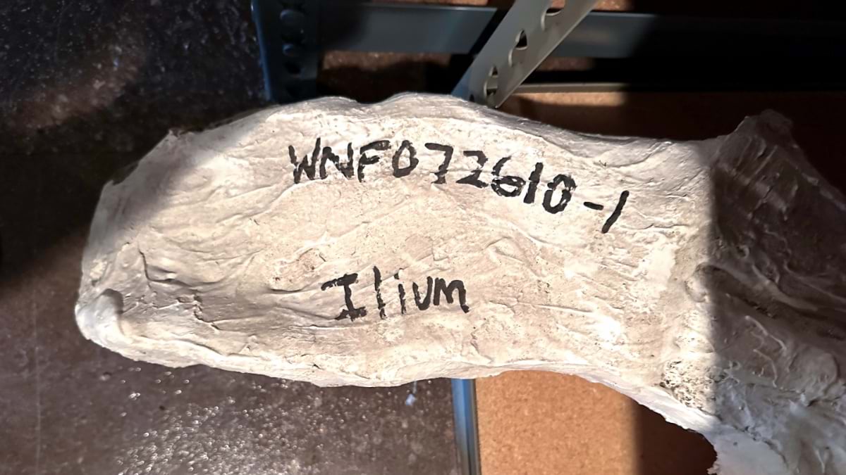
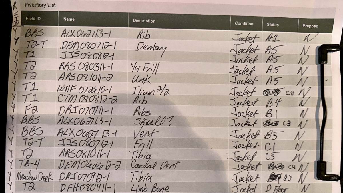
Elsewhere, at the Museum of Discovery at Sheridan College in Wyoming, Hebert and the museum’s directors spent five days in January cataloging about 700 fossils. Using ArcGIS Survey123 and ArcGIS Field Maps, they manually entered the handwritten GPS coordinates where each specimen was found, attaching an RFID tag to each. That way, a digital record will show where a fossil is at any given time—on a shelf, on display, on a researcher’s desk, or even on loan to another museum. Hebert is also adding other contextual metadata to each fossil including images, chemical information to determine the age, and research paper links.
Hebert has been determined to digitize the information that’s normally been handwritten on index cards and stored in museum cabinets. Digitization would make the data and fossils easier to access.
“Cards get lost, cards get damaged, and reading handwriting is often impossible,” he said. Stored in the cloud and pinpointed on a map, the digital records promise to reveal more about the Triassic, Jurassic, and Cretaceous periods, when dinosaurs roamed the land. Dusting off records and bones and digitizing the information to relate their origins could safeguard essential data about where dinosaurs lived and died, helping lead to better understanding about Earth’s origins and changes over time.
Learn about the Esri Partner Network, which supports GIS customers with business solutions.