

January 21, 2021 |
Brooks Patrick | Infrastructure
September 12, 2023
Vienna is a city in a bind. Austria’s capital, home to nearly two million people, is one of the European Union’s largest and fastest-growing cities. In four of the last five years, Vienna has held the top spot on The Economist’s annual rankings of the world’s most livable cities.
But a city can only remain livable if there are enough places for people to live. Vienna’s leadership has used the challenge of creating more housing as an opportunity to envision a new pattern of neighborhood planning and placemaking throughout Vienna—a city within a city.
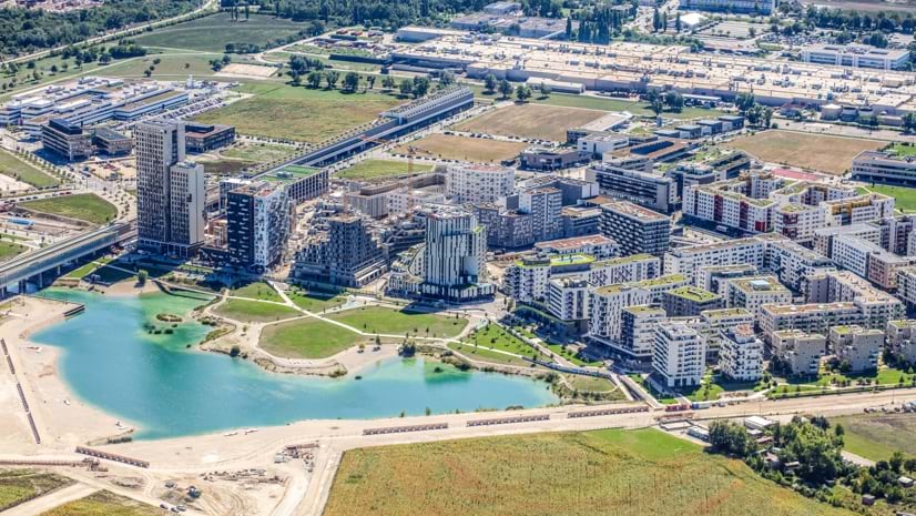
The result: aspern Seestadt, reclaims a brownfield area to create a development that embraces new urban ideals while retaining the classical urban structure of old Vienna.
As aspern Seestadt has evolved, it has emerged as one of Europe’s most dynamic planned communities and an incubator for smart city initiatives. Geographic information system (GIS) technology helps planners implement clean energy and low-emission strategies and aids the long-range planning and implementation to ensure that aspern Seestadt achieves a unique balance of sustainability and livability.

In the early 2000s, following a period of stagnation and slow growth, Vienna’s population began to skyrocket. Since then, it has increased by 25 percent. The city is projected to add 200,000 new residents by 2030.
As far back as the ’90s, Vienna’s political and civic leaders foresaw the strain population growth would place on the city’s housing stock. Political realities complicated the problem. Vienna is both a city and one of Austria’s nine provinces, surrounded by another, Lower Austria.
“It’s just not possible for Vienna to grow on the outside,” said Carina Huber, an urban planner with the development agency Wien 3420 AG, the corporation responsible for overseeing aspern Seestadt’s development. “The only opportunity is to adapt unused areas within the city.”
Casting around for land to develop, officials settled on the former site of Aspern Airfield. A major civil and military aviation facility for more than 50 years, Aspern had closed in 1977, just as Vienna was reaching its postwar population low.
When construction began in 2007, the site was a derelict former airport. Today, aspern Seestadt is a thriving community spread over 800 acres. When it is completed in 2030, it will be home to over 25,000 people and 20,000 workplaces.
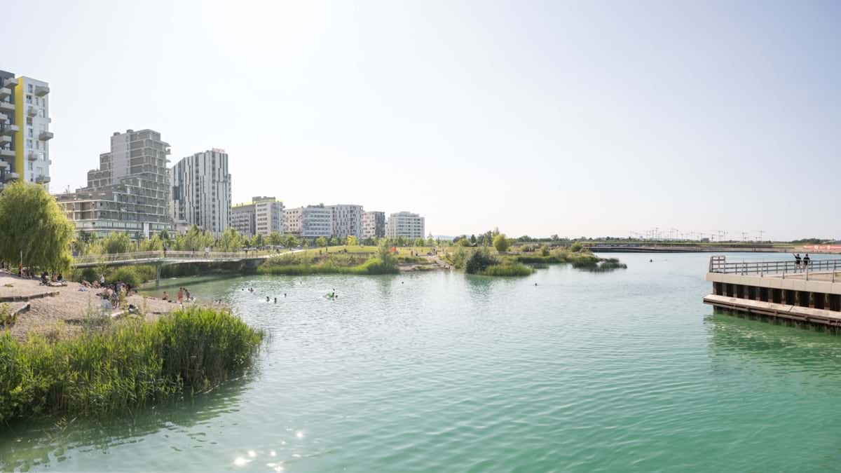
To begin to understand the scope of aspern Seestadt’s achievement, consider that this former brownfield now contains a swimmable artificial lake at its heart.
The lake is its own circular economy. A plant converts the gravel from the lake excavation into road base and aggregate for concrete. To date, 1 million tons of recycled material have been delivered. Keeping the material on site has saved 280,000 truck trips and 6,000 tons of emissions.
Aspern Seestadt has made an ambitious commitment to lower its impact on residents and the environment. The aspern climate fit standard was developed with the goal to meet a greenhouse gas-neutral economy by 2040, with high efficiency buildings, maximum use of renewable energy sources, e-mobility, and mitigating extreme heat in the summer.
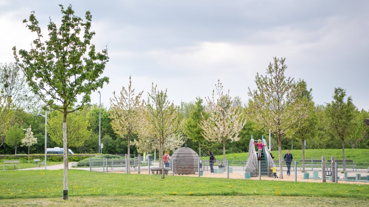
This balanced approach permeates the comprehensive plan that governs the project’s development. The plan emphasizes ambitious emissions requirements, both in the construction and everyday functioning of aspern Seestadt. Fifty percent of the area must be kept as undeveloped green and open spaces, with paths and treelined streets. At the same time, the area’s population density is nearly twice that of Vienna as a whole.
From the beginning, the City of Vienna saw aspern Seestadt as a test bed for smart city concepts, including a deemphasis on cars. The plan called for a 40-40-20 transportation infrastructure concept: 40 percent public transit, 40 percent walking and cycling, and 20 percent for personal vehicles.
Before any structures were built, the city built two metro rail stations in aspern Seestadt and extended the metro line to reach the site. It’s a 25-minute ride to reach Vienna’s city center, 15 kilometers away on the other side of the Danube. Since 2018, metro and railway lines meet at the transfer station Aspern Nord on the north side of the development, which makes for a 17-minute-trip to Vienna’s central train station.
“What makes Seestadt unique, I would argue, is that it maintains the transportation mode split of the inner city,” said Petr Bocharnikov, a digital strategist with Sokigo, the Swedish firm that together with Sweco has developed and deployed new GIS tools for aspern Seestadt. “Historic city centers to this day allow for a significant share of travel with public transport, cycling and walking, but new developments are much more car-oriented.”
Something else unique about aspern Seestadt is the way its overall urban philosophy has evolved and flourished. Instead of being a top-down vision emanating from officials of the City of Vienna, it is the product of an ongoing long-term collaboration among diverse public and private stakeholders.
This approach reflects what spatial planners Astrid Krisch and Johannes Suitner, in their analysis of aspern Seestadt, call “the switch from government to governance” in city planning. The priority is nurturing the emergent ideals rather than dictating them.
For this reason, Wien 3420 AG was created as a public private partnership with City of Vienna and two additional shareholders in 2003. The agency serves to coordinate all the inputs, a task aided by GIS.
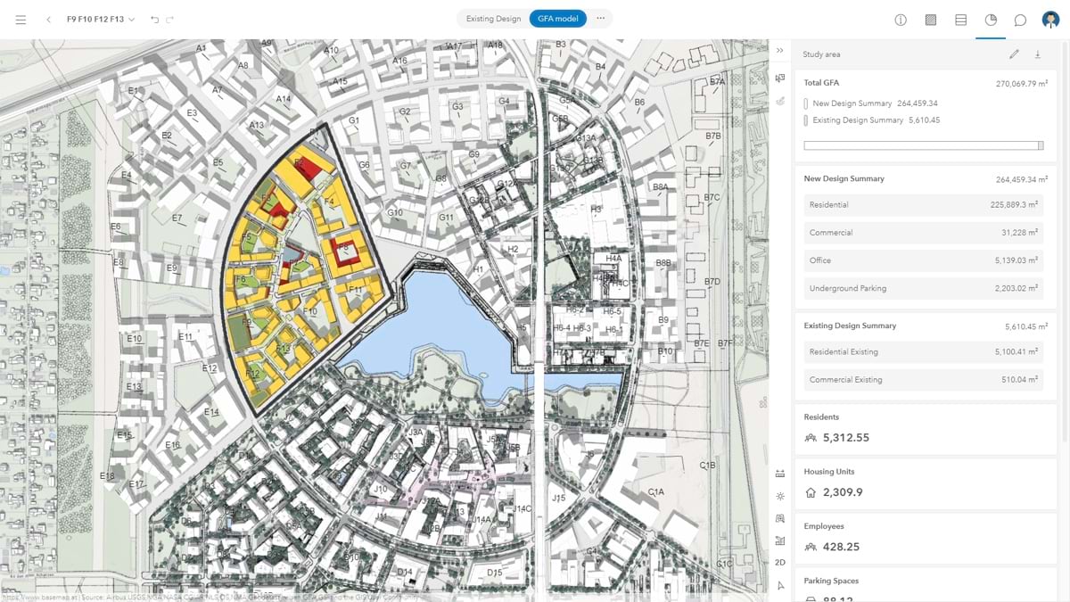
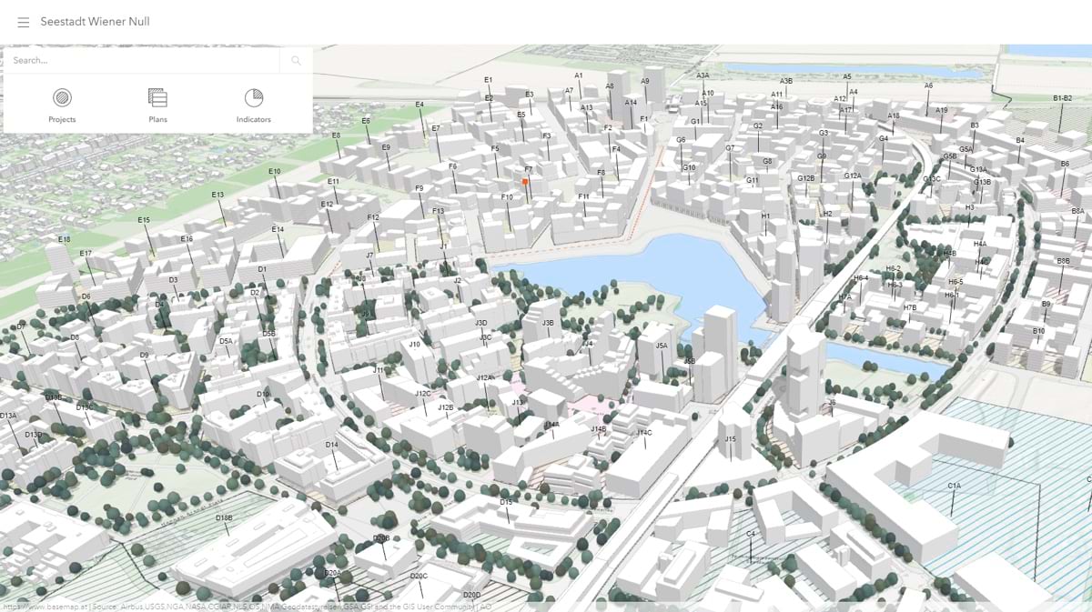
In the early days of planning and construction, Wien 3420 AG used GIS primarily to print updated maps that displayed the project’s progress. As aspern Seestadt has taken shape, GIS has become a powerful integrated tool for planners and architects. GIS now provides a common virtual meeting space for project-related data and creates a foundation for including detailed infrastructure drawings (CAD) and building information models (BIM).
The agency uses GIS to create an unfolding visual documentation of the plan. People involved with the project can take parts of the map relevant to their duties and integrate them into workflows for planning, constructing, operating, and marketing the development.
Huber referenced one of the earliest aspern Seestadt maps, depicting the comprehensive plan for the development. “It’s been with us from the very beginning,” she said. “It shows all the usages and open spaces. It’s the most used map in the whole company.”
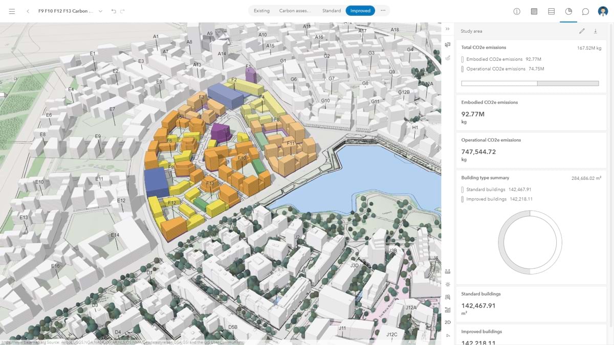
Over time, the map has been augmented by dashboards that show aspern Seestadt’s progress. These help all project stakeholders understand whether the project is meeting its goals. For example, it can provide information about total emissions of proposed buildings based on the building function and expected construction standard. It also helps everyone involved understand the schedule for completing various phases of the development.
“We can combine 2D information with the 3D model we now have,” she said. “We can picture an already constructed building block, and we can load in contracts and PDFs.”
As aspern Seestadt has progressed, GIS technology has advanced along with it. The result is a realistic vision of the town that would have been impossible when the project was first conceived. As Bocharnikov wrote in a recent project update, “We’re transforming traditional GIS into a project information model, and ultimately, a digital twin.”
This geospatial digital twin, built using ArcGIS Urban, serves an important purpose in documenting the present and the past. But the twin also holds enormous importance as a way to understand the future and tweak the comprehensive plan accordingly. The town has always had goals related to climate change—both in terms of building the development with a minimum carbon footprint and ensuring heat mitigation strategies. The twin guides the planners in making data-driven decisions to reach these objectives.
The twin also provides a record that lets planners change tactics in new parts of the development based on lessons learned from earlier phases. Stricter energy efficiency standards were recently applied to the next phase of development. The digital twin provides visual communication of the change as well as quantifying gains in efficiency. It keeps aspern Seestadt focused on its goal of being a new sustainable and forward-thinking energy-efficient development in Europe.
“This gives every member of Wien 3420 the possibility of seeing a complete picture, including completed buildings, the master plan, modifications of the master plan, and architectural projects that are being refined,” Bocharnikov added. “Our goal is for every member of the organization to directly access it in their work. That’s very valuable for collaboration within the agency.”
Learn more about how GIS is applied to create smart urban and community plans.