Are you ready to hear inspiring stories, see the latest technology in action, and learn from your peers at the 2023 Esri User Conference (July 10-14)? This year the world’s largest GIS conference will be held in-person in the beautiful city of San Diego.
We’re excited for you to experience the power of ArcGIS technology. To help you plan your time at the conference, we’ve carefully curated an agenda with a list of ArcGIS GeoPlanner sessions that you may find valuable. Get ready to connect with technical experts, peers, and exhibitors through insightful conversations about all things GIS.
Agenda
Showcase

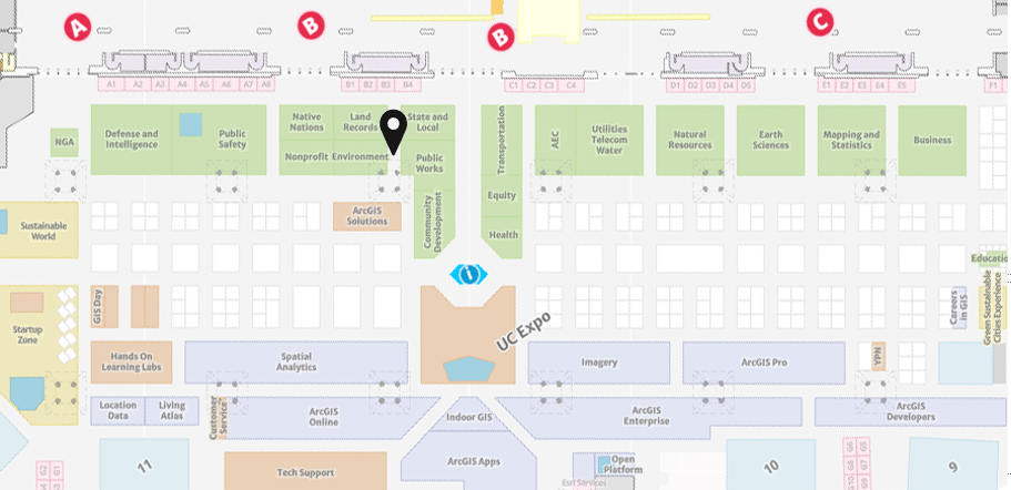
The UC Event Map is now available to familiarize you with the convention center and view locations of sessions and activities before you go. You can also generate a route and directions between two locations and view the estimated travel time.

ArcGIS GeoPlanner can be located in the Environment industry showcase. Use this map a helpful tool, along with the Detailed Agenda and My Schedule, for planning your UC experience. The map will also be available in the Esri Events App and at directory kiosks on site in the convention center. Learn more.
Showcase hours
Tue, July 11: 09:00 a.m. — 06:00 p.m.
Wed, July 12: 09:00 a.m. — 06:00 p.m.
Thu, July 13: 09:00 a.m. — 04:00 p.m.
Sessions
Tuesday, July 11
Geodesign and Digital Twins: The Road Ahead
Tuesday, Jul 11 | 10:00 AM – 11:00 AM PDT | Room 30 B | TECHNICAL WORKSHOP
More than ever GIS technology is transforming the way we design and plan our communities, regions, and the world. This digital transformation of traditional planning has given rise to a new and exciting field – Geodesign. In addition, we also hear the term Digital Twin everywhere these days. But what are they really? And what role should GIS and Geodesign play in implementing Digital Twins? Join us in this session to learn more about the fundamentals of Geodesign and explore some examples of how ArcGIS can play a supporting role in building your next digital twin.
Visualizing Growth and Development to Make Informed Decisions
Tuesday, Jul 11 | 1:00 PM – 2:00 PM PDT | Room 28 B | USER PRESENTATION
Planners play a key role in guiding policy and decision-makers. GIS provides planning professionals with the tools to understand suitability for development and land use, analyze the impact of various strategies, and to identify the best approach for projects. Join this session to learn more.
ArcGIS GeoPlanner: An Introduction and What’s New
Tuesday, Jul 11 | 2:30 PM – 3:30 PM PDT | Room 30 D | TECHNICAL WORKSHOP
ArcGIS GeoPlanner is a web-based planning and design tool that empowers you to iteratively analyze, design, and evaluate multi-scale scenarios in a collaborative environment. GeoPlanner is designed to develop context-specific planning and design alternatives, evaluate their performance, and better understand and communicate their impacts via configurable dashboards and reports. Join us to learn more about GeoPlanner, its newest capabilities, and how it can be used to support geodesign-based workflows specific to natural systems and landscape planning.
Wednesday, July 12
ArcGIS GeoPlanner: An Introduction and What’s New
Wednesday, Jul 12 | 4:00 PM – 5:00 PM PDT | Room 30 B | TECHNICAL WORKSHOP
ArcGIS GeoPlanner is a web-based planning and design tool that empowers you to iteratively analyze, design, and evaluate multi-scale scenarios in a collaborative environment. GeoPlanner is designed to develop context-specific planning and design alternatives, evaluate their performance, and better understand and communicate their impacts via configurable dashboards and reports. Join us to learn more about GeoPlanner, its newest capabilities, and how it can be used to support geodesign-based workflows specific to natural systems and landscape planning.

Article Discussion: