Esri recently introduced a new web-based app designed to simplify the creation, updating, and maintenance of indoor maps for everyone, making it accessible to both GIS experts and non-experts alike – Floor Plan Editor. In our webinar in March, we showed how you can use the app to easily create and maintain indoor maps that help streamline your facility management, emergency response, and occupant experience.
We want to thank you all again for showing so much interest and asking many questions during the webinar. As we didn’t have a chance to answer all of them in the live session due to the time limitation, and as promised, we wanted to share our answers with you after the session. In this blog, you can find answers to the frequently asked questions about the Floor Plan Editor. You can also watch the webinar recording.
Licensing Questions
Do you need to have ArcGIS Enterprise to use ArcGIS Indoors and Floor Plan Editor?
ArcGIS Indoors is available on both ArcGIS Enterprise and ArcGIS Online. Floor Plan Editor is currently available in ArcGIS Enterprise 11.2 and requires branch versioning. It will be available in ArcGIS Online in a future release; please stay tuned.
What license and user type/role are required for Floor Plan Editor?
Floor Plan Editor is included in the Indoors Spaces license, which is an add-on to the Indoor Maps license. The user type required is Editor or higher.
Is Floor Plan Editor available in the version that K-12 students use?
Floor Plan Editor is available on ArcGIS Enterprise 11.2 and requires the Indoors Spaces license. Please reach out to your account manager for further information on your license.
Technical Questions
How do I access Floor Plan Editor?
Make sure you have a floor-aware web map created for Floor Plan Editor shared from ArcGIS Pro to your ArcGIS Enterprise. Then follow these steps:
1. Login with a user that has a Publisher role
2. Go to the Content tab and click the Create App button
3. Select Configurable Apps
4. Select Show All and enter ‘Floor’ in the search box
5. Choose Floor Plan Editor
Can information be imported from BIM software like Archibus?
Yes, in ArcGIS Pro. The formats that are supported for floor plan geometry are CAD, REVIT, IFC. Attribute data can also be exported and imported with tools in ArcGIS Pro.
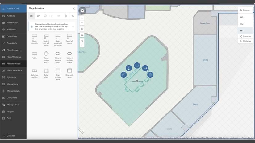
Are you able to create your own custom furniture or upload template furniture from CAD/ BIM into the floor plan editor?
Yes, you can create custom entryway, window, and furniture templates.
How can the individual room data be used for reporting such as dollar density?
You can use the created floor plan data to create dashboards and reports in ArcGIS Pro using ArcGIS Pro’s reporting tools or create reports through 3rd party reporting solutions.
Can you provide an online lesson for beginners to get started with ArcGIS Indoors?
We provide online training materials for all levels, such as self-learning web courses and instructor-led training. Please check our training website.
Can we integrate the created indoor floor maps to an address point feature class?
You can view floor plans created in Floor Plan Editor as a web map in the Map Viewer application included in ArcGIS Enterprise, where you can search for addresses and add other data like point feature class.
Can Floor Plan Editor be used to create a room layout, for example of an Emergency Operations Center EOC or a Shelter / Evacuation Assembly Center?
Yes.
Will it be applicable with BI tools like Power BI?
You can add the feature layer from the indoor map used in Floor Plan Editor using ArcGIS for Power BI for further analysis, provided you have the necessary data included in your floor plans.
Can you export the floorplans back out to AutoCAD
Yes.
I’m interested to see how the create transition tool works.
It works the same way as entryways, walls, or furniture. You can place transitions like stairways and elevator shafts.
Can data created in ArcGIS Pro be loaded into Floor Plans?
Yes, the data you edit in Floor Plan Editor can be viewed, edited, and analyzed in ArcGIS Pro. You can edit the data from ArcGIS Pro in Floor Plan Editor. Floor Plan Editor and ArcGIS Pro can edit the same feature layers.
Can this module find the “best route” to an emergency exit?
Routing and Wayfinding is a capability of Indoor Viewer and Indoors Mobile applications and requires creating an indoor routable network created using Indoors tools included in ArcGIS Pro.
Does ArcGIS Indoors allow for indoor positioning?
ArcGIS Indoors supports indoor positioning through ArcGIS IPS on iOS and Android mobile devices. Visit the ArcGIS IPS product page to learn more.
For indoor positioning, I’ve heard that the indoor environment needs to install Bluetooth beacons, can it use WiFi access points?
Yes.
By simplifying the map-creation process and putting the power of creating indoor floor plans and maps into the hands of operations and facilities personnel, we aim to empower organizations to start efficiently managing their indoor spaces with floor-aware indoor maps. The Floor Plan Editor is designed to be accessible and user-friendly, enabling users to create accurate and detailed floor plans with ease.
Watch the webinar recording
Learn more about ArcGIS Indoors, Floor Plan Editor and ArcGIS IPS.


Commenting is not enabled for this article.