Transportation hubs such as airports serve as the perfect ground for a variety of indoor mapping and positioning use cases. Indoor positioning at airports can not only help passengers navigate, it also allows the airport and on-site businesses to operate in the most efficient way.
From City Airports to Airport Cities
Over the decades, airports have gone through a tremendous evolution, changing from mere city airports to actual “airport cities”. Airports nowadays don’t limit themselves to transferring passengers from one destination to the next. They strive to take the airport experience to a completely new level to provide highest comfort to all travellers and encourage them to spend more time and money on the activities on offer.
Consumer and leisure services are outdoing each other in this regard. Offers range from retail stores and restaurants over yoga studios and spas to even movie theaters and cultural exhibitions. However, in order to be able to provide the highest comfort and best customer service to their customers, first and foremost, it is crucial for airports to optimize their internal workflows and efficiencies.
Indoor positioning and navigation technology is able to address these needs as well as pave the way for innovative marketing strategies and connection with other transportation services outside the airport.
Here is a short overview of the challenges and chances at airports indoor positioning can tackle:
Challenges and Chances at Airports:
- Time critical business – need for optimal time management
- Internal processes – provide a common operating picture
- Work order management – efficient resource allocation and management
- Airport management – better informed decisions with indoor analytics
- Great number of passengers served – efficient workflows needed
- Vast area; flight delays are cost intensive – passenger transition guidance
- Airports as “cities” – entertainment and cultural services demanded
- Transportation hub – seamless connection to taxis,and other transportation services needed
- Passengers with Reduced Mobility (PRMs) – wheelchair tracking and personnel monitoring
- Retail space rental – optimized through visitor traffic insights
Work Order Management and Resource Allocation
As air travel is a time critical business, one of every airport’s top priorities is that all processes run smoothly and without any major interruptions. Serving thousands of passengers on a daily basis, big airports run the risk of congestions and crowd forming, e.g. in security or the customs area. Bottlenecks in human resources and disruptions in workflows can be avoided if a comprehensive location-based management system is in place.
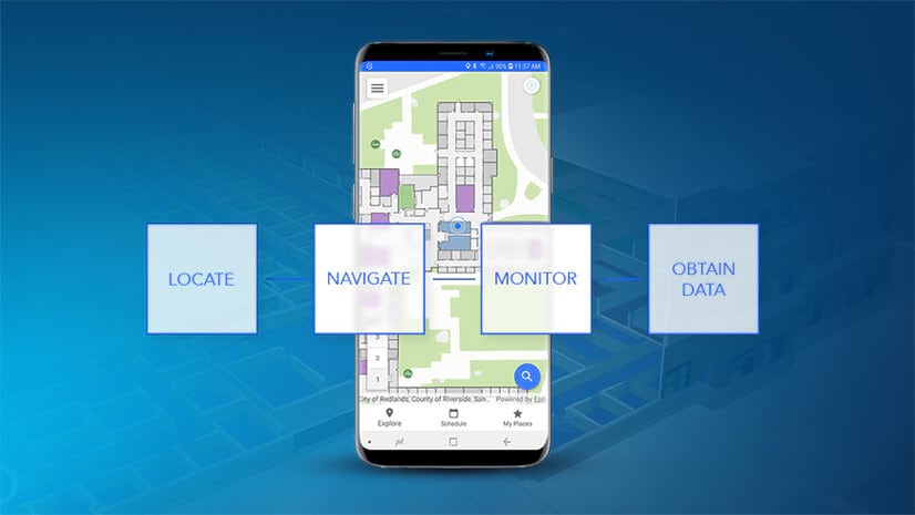
ArcGIS Indoors allows users to see beyond the obvious and keep track of every resource inside the airport building. With Indoor GIS enabled, all on-site processes and workflows become more transparent, creating a common operating picture for all stakeholders.
Let’s say the infoscreen at Gate 22 is broken. Any on-site personnel noticing it can use the app and mark the exact position on the airport building map. Adding a note about what needs to be fixed and submitting a repair request makes fixing damages or defects a lot easier. The technicians will be notified about the repair request.
As soon as a team member accepts the task per click, this information will show up on everyone’s device. The technician can then navigate directly to the respective infoscreen using the app. This system ensures that repairs and maintenances happen timely and efficiently.

Indoor Analytics for Better Informed Decisions
With ArcGIS Indoors, airport managements are able to access information they need to make qualified decisions. Where do crowds tend to form and congestions happen? How much time do visitors spend on average at the airport? How do they move through the airport? Where do resource bottlenecks occur? Analytical data serve as the backbone for better informed decisions and the ensuing measures taken.
Whereas airports as a whole can use anaytical data to improve the way they operate, individual on-site operators are just as eligible to use them for their purposes. Retailers for instance can check movement patterns, frequencies and dwell times of customers inside their shop. These insights help them see which marketing campaigns work best and where there is room to optimize. Speaking of which, the data can also be an indicator of whether the shop layout is good as it is or should rather be changed to encourage sales.
Complementing an optimal store layout and in-store marketing campaigns, the retailer can also think about using a couponing system. In this case, the indoors technology would trigger push notifications on the app user’s mobile upon getting in close proximity of the store.
Safety and Security at Airports
Security is absolutely crucial for airport management. Managing the security force effectively is therefore just as important. Using indoor positioning services, it is possible to determine the real time locations of every security guard to check if they are at their assigned position or route. In case of an incident, knowing the locations of all guards allows the team to send those closest to the incident, according to the map, to help.
Similarly, first responders can use the mobile app as a means of support to orient themselves and locate the emergency site faster. By picking up the position signal that can be shared on the map, the crew can navigate there instantly, without losing precious time trying to figure out the right way.
Indoor Mobile Wayfinding for Passengers
Besides bad weather conditions or air traffic congestion, flight delays are often caused by passengers who are lost and can’t find their way to the right gate on time. Flight delays incur heavy costs on both, airline and airport. In addition, they lead to opportunity costs for all passengers and a negative travel experience on top of that.
In order to minimize the risk of delays, using real-time mobile wayfinding, passengers can easily navigate to the right gate on time. Using their smartphone, they are able to route themselves to the gate in real-time while the estimated duration is calculated on the device.
Seamless Transition to Local Transport Services
Transfer doesn’t stop at the airplane. A successful travel experience also includes seamless connection to transfer opportunities from the airport to the hotel. While passengers claim their luggage, they can order their taxi, Uber, or other shuttle services and then easily navigate directly to the right car.
Modern airports that integrate indoor positioning and navigation technology, can be regarded as part of the smart city approach, whose goal is to facilitate citizens’ lives through innovative technologies in all kinds of everyday life situations, e.g. smart living, smart mobility, smart retail, smart working etc.
Indoor positioning can contribute significantly to airport life by equally supporting airport, airlines as well as passengers. It also helps propel the smart city concept. The ArcGIS Indoors technology which is directive for the industry, allows for a variety of use cases which altogether help increase efficiency, ROI and employee & customer satisfaction.
Interested to learn more about indoor positioning? Check out ArcGIS Indoors, the smart building management and mobility system or get in touch with one of our experts directly:
Marco Viola, Account Executive | ArcGIS Indoors


Commenting is not enabled for this article.