Flooding is one of the most frequent and deadliest of natural disasters. With billions of dollars of damage and thousands of lives taken each year, its no wonder why countries invest so heavily in monitoring and predicting flooding.
ArcGIS Living Atlas of the World has many resources for understanding current and potential flood conditions and impacts around the world, and one of them just got a major upgrade.

Improvements to Live Stream Gauges
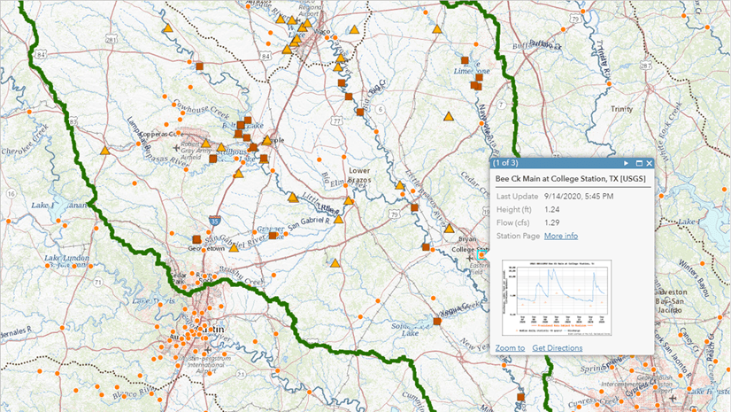
Stream gauges are sensors placed in rivers and streams to measure variables like water height and flow speed to understand the risk for flooding (or drought). Many national and state agencies, universities, and NGOs operate networks of stream gauges around the world. For years, the Esri Community Maps Program has allowed organizations to contribute their stream gauge information into a centralized database, simplifying access to this critical information.
A new version of Live Stream Gauges was just made available in Living Atlas, and it includes several upgrades:
- Migration to a hosted feature service, making it more scalable and performant with a variety of applications
- Added networks from Canada and England
- New logic in the Aggregated Live Feeds Methodology that automatically discovers gauges added or removed from a network
- Stream gauges without data updates are removed after 180 days
- New field that calculates hours since last update for each gauge, which can be used to filter older data
- Fields provide metric and imperial units
- Updated cartography with symbols indicating “Flooding Status”, where that information is available, and stylized to work with the GEOGLOWS global stream flow forecast layer and web map
- No longer requires a subscription to access
The layer checks for updates every hour, though individual stations vary in their update frequency.
The new version replaces the original map service of Live Stream Gauges. Please check your maps and apps to make sure you’re using the most current version, as the older one will eventually be retired. How can you tell? Looks for the Living Atlas badge, along with the dark basemap thumbnail and “Feature Layer” layer type.

If you’re aware of additional stream gauges that can be added to this service, please contact environment@esri.com or visit the Esri Community Maps Program.

Article Discussion: