Since the release of ArcGIS Pro 1.4 it has been possible to publish various 3D feature types from ArcGIS Pro to the I3S scene layer format an OGC community standard, beginning with 3D object multipatch features to ArcGIS enterprise. Since then the list of supported feature types has grown to include 3D Objects (Multipatch), Point, Integrated Mesh (Drone2Map, Pix4D, ContextCapture, VRICON) and since ArcGIS Pro 2.0 Point clouds in LAS, ZLAS an LAZ formats.
This blog will focus on the organization, publishing and management of point cloud data to I3S point cloud scene layer format. From the initial gathering of LiDAR point cloud data to the generation of a point cloud scene layer package (SLPK) for uses locally in ArcGIS Pro or for publication to ArcGIS Online as a scene layer.
If you don’t have your own collection of LiDAR, LAS, ZLAS or LAZ files lying around on Hard Drive or set of DVDs from a long-forgotten flood mapping or elevation survey, there are plenty of free sources of LiDAR point cloud data available through government and non-profit organizations.
Open Topography based out of the San Diego Supercomputer Center at the University of California, San Diego provides access to a wide array of high resolution earth science LiDAR data.
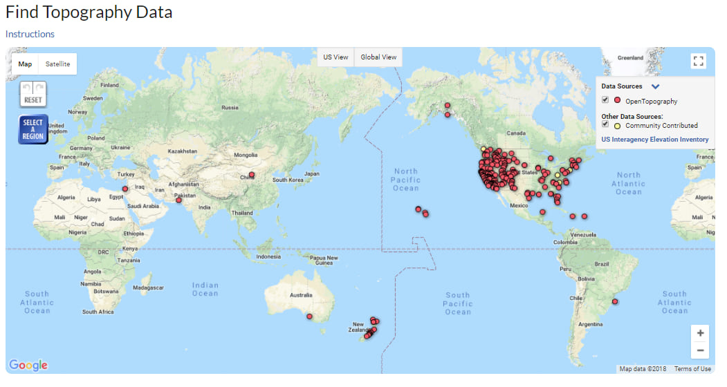
The United States Interagency Elevation Inventory gives users access to a wide variety of LiDAR, IfSAR and Bathymetry point cloud data for many areas in the USA.

One of the free datasets available on the United States interagency elevation inventory is the 2014 USGS CMGP Lidar: Post Sandy (New York City) dataset. Which was acquired and processed to assist in the evaluation of storm damage and erosion of the local environment as part of USGS Hurricane Sandy response along the Atlantic Seaboard. I will be using this dataset to demonstrate the processing and publication of point cloud data.
Using the United States interagency elevation inventory site, you will be directed to the National Oceanic and Atmospheric Administration data access viewer.

Selecting the New York vicinity provides you with the all the information to download the LiDAR data and full metadata on its collection and processing.

Once the data has been downloaded you have 24GB folder of 510 LAZ data files. Which you can now either convert directly to a point cloud scene layer. Or if you wish to carry out further filtering, classification or analysis on. You can convert to LAS and a LAS Dataset for processing and analysis in ArcGIS Pro. Using many of the LAS Geoprocessing tools there.
To convert the LAS ZLAS or LAZ point cloud data into a PCSL SLPK. Open ArcGIS Pro, navigate to the “Create Scene Layer Package” geoprocessing tab. Drag the folder containing the LAZ files into the input Layer dialog. Select an output folder. Define what attributes to cache. Finally select the output coordinates or use the default GCS_WGS_1984 which transforms the input projection, in this case NAD 1983 to WGS 1984.

The process is similar to output a PCSL SLPK for a LAS dataset. Except you can define the point render type (Elevation, Classification, Intensity or RGB color if present). Add the LASD dataset to the map then add it as the input layer to the “Create Scene Layer Package” tool. Once you have entered all parameters click on run and the data will be processed into a single point cloud scene layer package (SLPK).

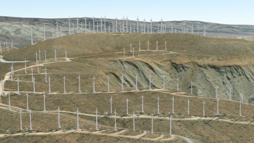
Once the SLPK has been generated you can view it in ArcGIS Pro by adding it to a scene using the add data button on the Map tab.

To publish the scene layer package to either ArcGIS Enterprise or to ArcGIS Online use the Share Scene layer package tool.

Filling out a Summary description, Tags used to describe and identify the package and credits for the source and providence of the data used.
Once shared to ArcGIS Online the package can be published using the publishing button on the Scene Layer Package properties page. The published scene layer may then be shared within your organization or to the public.
Be sure to add detailed description and source credits to the resultant hosted scene layer.
You can now add this point cloud data to a web scene along with other 2D or 3D online services.

Or consume the scene layer services along with local data in ArcGIS Pro.

These are just some of the ways in which you can share and publish you very large LiDAR Point Cloud datasets locally and to ArcGIS Online. To review other examples of point cloud scene layers check out the 3D Scene Layer Group on ArcGIS Online.


Commenting is not enabled for this article.