Happy mapping! This update includes features you’ll want to try out right away. With layer groups, cluster labeling, and layer blending, you are certain to have fun building your next web map. Improved symbology, tables, and new map properties will also bring your maps to the next level.
Layer groups
Organize layers in your map or app into groups using the layer groups functionality in Map Viewer Beta. Using layer groups, you can conveniently turn groups of layers on and off and quickly reorder groups of layers. You can also show more levels of geography for a single data set.
Get started with layer groups
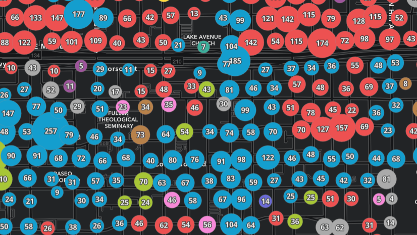
Labeling options for clusters
Add clarity to your clusters by including a label that appears on each symbol. The label can show the number of points in the cluster or the average value of the clustered points. You can also customize the font, size, placement, offset, and halo of your labels, as well as set the minimum and maximum size of the clusters.
Learn more about cluster labeling

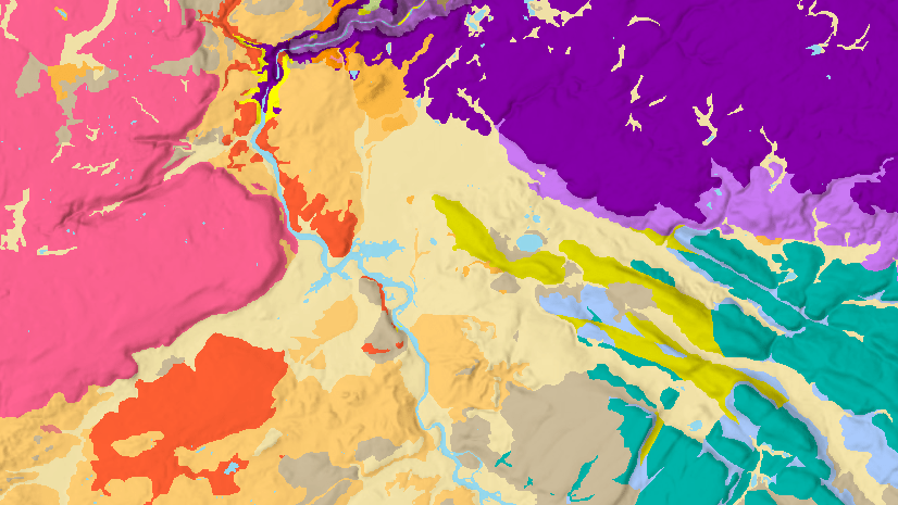
Sophisticated layer blending
A blend method takes two or more layers and “blends” the pixels normally drawn by each layer. Map Viewer Beta now includes 30+ blend methods which give you control over what shows through and how colors and textures between layers appear. You’ve probably used layer transparency in the past and been disappointed with a washed-out result. Blend modes gives you the power to enhance your maps without obscuring them. Blending is a property setting on a layer. This means your layers remain independent, and you can easily turn blending off and return to the layer’s original state.
Get started with blend methods
Improve your thematic maps with blend methods

View your attribute data in tables
You’ll quickly find that working with tables in Map Viewer Beta is like working with tables in the original Map Viewer or on the data tab. To open a table in Map Viewer Beta, use the contents toolbar (left side) to open the layers pane and select ‘Show table’ in the options menu.
See a complete list of current and upcoming table capabilities
Improved symbology
New vector point symbols, which look sharp at all scale levels and whose colors can be changed, are available to style point features. Additionally, Map Viewer Beta can display custom vector 2D collections published with the upcoming ArcGIS Pro 2.6.
See what’s possible with the new symbols
New ways to author basemaps
Basemaps are key for building good web maps. Map Viewer Beta includes new features that make it easier to author effective basemaps.
- Easily discover and use basemaps from the ArcGIS Living Atlas of the World within the basemap window.
- Modify, rather than replace, the current basemap in your map by adding or removing layers.
- Use techniques such as rotation, blending, and background color to craft web maps where the basemap and other layers in the map combine to produce powerful visualizations.
Explore all basemap enhancements
New settings for your entire map
Map properties is the place to adjust settings that apply to your entire web map. Two new properties are available including preserve map scale and enable background color.
When creating a web mapping application, it’s critical for the app to open with the best possible starting location, on all screen sizes. To maintain a uniform scale in the initial map view across many screen sizes, enable the preserve map scale option under map properties in Map Viewer Beta. This saves the scale with the web map and ensures all applications that open the map focus on the same point.
Learn how to set your map view
Background color can be used on its own or in combination with layer blending. In some instances, especially when using custom basemaps, you may need to set a background color for areas the basemap doesn’t cover. The basemap color could be part of the overall thematic focus of the map or it could be a color that fits in with organizational themes.
Get started with background color
Filter labels with any attribute
In Map Viewer Beta you can filter labels with any attribute. This allows you to interactively filter out the labels below a certain value.

Continue the conversation
Users give us many feature improvement ideas, and this update of Map Viewer Beta in ArcGIS Online brings many of these ideas to life. Check out the full list, and continue submitting your ideas!
Please join us in the Map Viewer Beta GeoNet space to discuss the new functionality, ask questions, and provide feedback.


Commenting is no longer enabled for this article