Physical infrastructure projects generally involve modification of ground, requiring considerable efforts for planning, design, and construction. Establishing centralized access to ground surface models for use by designers and stakeholders during these project stages promotes collaboration and allows for more broadly informed design decision-making. Additionally, removing data silos when characterizing existing ground—and managing frequent changes to proposed ground surface models—reduces the chances of discrepancies and rework.
Workflows that avoid use of surface models siloed in files also lead to smoother cross-team collaborations, such as those involving civil engineers and GIS professionals. Maintaining centralized, readily accessible models of surfaces across the teams of organizations is crucial for ensuring data consistency and accuracy throughout the project lifecycle (for example, ensuring up-to-date analysis of proposed surface models for design). ArcGIS Pro provides a set of tools that facilitate non-siloed workflows, drawing upon commonly used triangular irregular networks (TIN) as surface model representations. Namely, the terrain dataset in ArcGIS Pro is a multiresolution, TIN-based surface built from measurements stored as features in a geodatabase, including an enterprise geodatabase.
Streamlined approach for generating terrain models
Previously implemented capabilities in ArcGIS Pro support a manual process for working with terrain datasets. However, the manual process requires use of several geoprocessing tools in sequence. Furthermore, in certain tools, you must also specify parameters related to the surface model characteristics (for example, the extents) as well as parameters that may involve separate calculations.
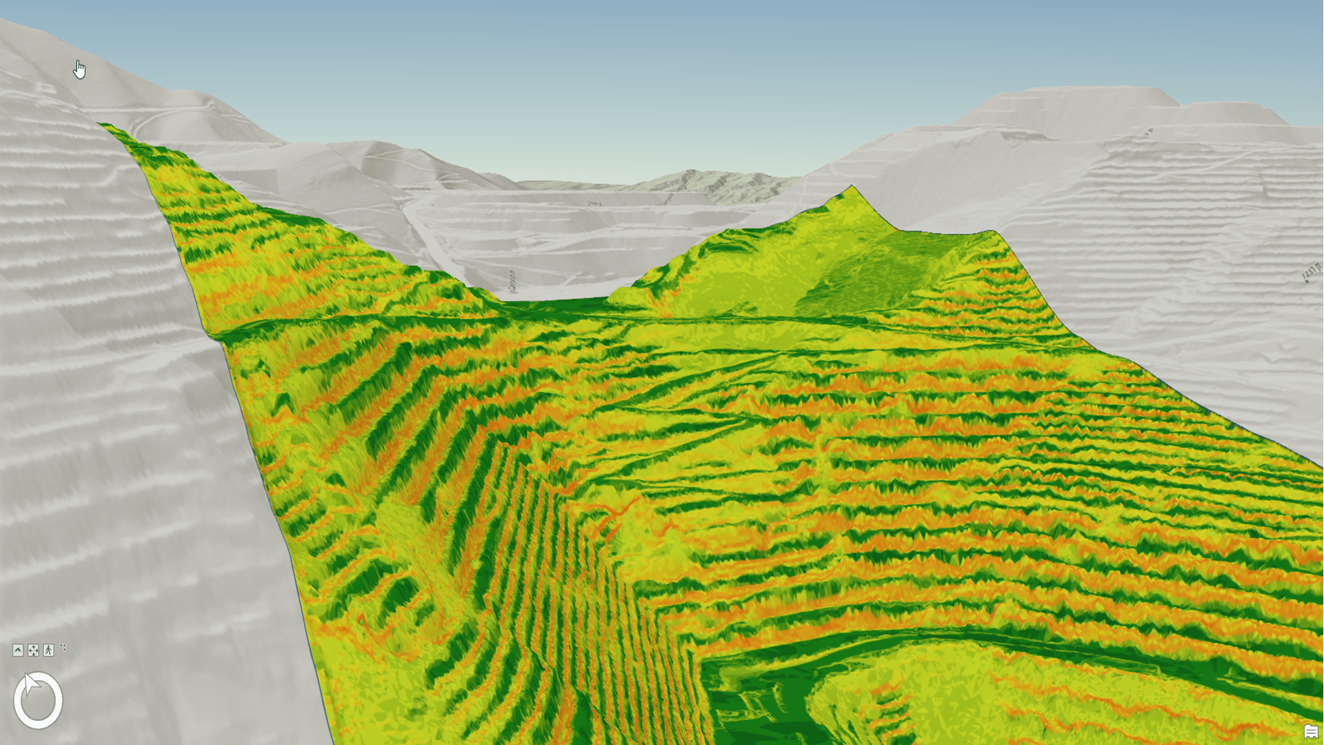
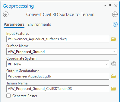
Available feature classes relevant to surface modeling (SurfaceBorder, SurfaceBoundary, Breakline and SurfacePoint) provide a backdrop for streamlined use of terrain datasets. Terrain models generated in this way uphold the accuracy of TIN surface models originating in Autodesk® Civil 3D®. To further streamline this process, a script is available: Convert Civil 3D Surface to Terrain.

After connecting the script to the project toolbox, terrain datasets can be created in a streamlined process, in which the script combines the following steps:
- Selecting a TIN surface of interest from an Autodesk Civil 3D .dwg file.
- Creating the terrain dataset in a geodatabase with the coordinate system assigned to the .dwg file.
- Creating the terrain in the new dataset after calculating the point spacing, based on a screen width assumption.
- Defining the pyramid level based on visualization scales.
- Bringing the feature classes SurfacePoint, SurfaceBorder, SurfaceBoundary and Breakline filtered by, and corresponding to, the selected TIN surface from the .dwg file into the new dataset using the Select geoprocessing tool.
- Adding the feature classes to the terrain, ensuring that for the SurfaceBorder feature class, the setting is HardClip to ensure the correct final limits (extents) of the terrain.
- Building the terrain.
- Optionally, creating a raster layer that corresponds to the terrain, for use in visualization workflows. Additional discussion is provided in Terrain Datasets as ground – creating scenes in ArcGIS Pro and publishing to ArcGIS Online.
Note that the script is intended for use with surface models that contain fewer than 2 million points when represented as a TIN in Autodesk Civil 3D.
Benefits of the streamlined approach
Use of the script effectively automates the sequence of calls to the geoprocessing tools and specification of parameters necessary to create terrain models in ArcGIS Pro. The script capabilities also include automated naming of the various entities that are created along the way. This approach produces highly accurate surface models with a single processing tool (script) and minimizes the otherwise necessary efforts of specifying and calculating several surface model parameters.
In turn, focus of the overall workflow in ArcGIS Pro can remain on how to make effective use of the terrain model rather than how to generate the terrain model. Furthermore, existing functionality allows for key components of the terrain dataset to be stored in centralized locations such as an enterprise geodatabase. For example, mass points in the terrain model (for example, the points of the TIN) may physically correspond to topographic survey data collected for characterization of existing ground. Storing the points (for example, as a point feature class) in a centralized location allows for other interested parties in the organization to work with the most up-to-date data when carrying out activities such as analyzing differences between existing and proposed ground surface models.


Article Discussion: