High resolution elevation data is readily available these days. Common sources include airborne Lidar or photogrammetric processing, both of which result in a point cloud that can be rasterized to produce a product known as a DTM (bare earth) or a DSM (bare earth plus features). Digital Terrain Models are great for hydrological applications, landuse planning, or for mapping soils. Digital Surface Models can be used to check for vegetation encroachment along electrical transmission lines, or to perform viewshed analysis for hypothetical construction plans to check how a new building might affect existing residents’ view.
The Pixel Editor has a variety of tools to help you edit DTM’s and DSM’s. In the past, you could still incorporate a new proposed building into your DSM, but it wasn’t as simple and straight forward as it is now. It often required existing features and multiple Geoprocessing tools to achieve the result. The Pixel Editors interactive nature allows for fast modeling of new buildings or other structures. The Operations gallery provides tools for many other scenarios you may encounter.
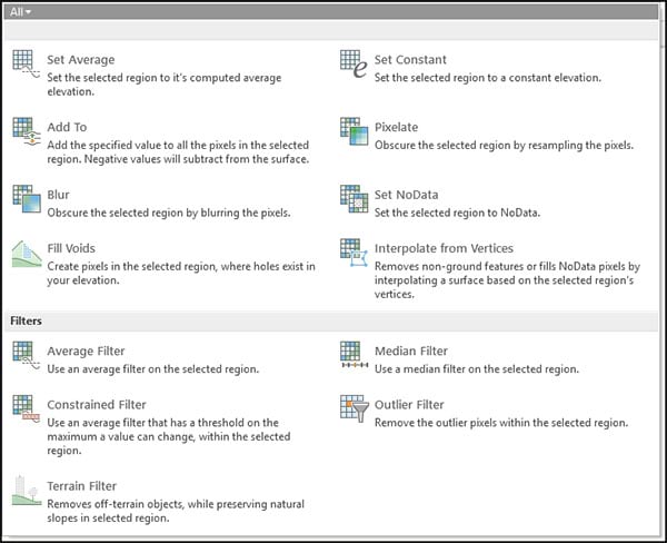
Example Operations
Water bodies are notoriously problematic areas for Lidar due to the light absorption properties. Additionally, water bodies can have boats, buoys, or vegetation on or above the surface, where overhang from nearby trees can cause undesirable artifacts in the resulting raster dataset. Let’s look at how the Pixel Editor can address some of these situations. In the image below, we can see there is quite a bit of NoData off the coastal area. I addressed this by using the Fill Voids operator during my edit session.

In the next image we have a lake with a small island of vegetation. Along the shore there are some artifacts. Other anomalies can be found inside the lake boundary. Let’s assign a constant value to the lake and preserve the island using the Exclude Region Intersections option. In this case you need to draw two polygons; the lake shore and the island you want to preserve. Click the Retain button on the Pixel Editor tab so you can see both polygons. Then select the region that outlines the lake. The Set Average operation was used to level the lakes surface. It computes the average elevation and assigns all pixels in the region to the calculated value.

In the next example we can see things like cars and freeway signs impacting road conditions. Using the Average Filter or the Median Filter works really well on roadways to remove these surface features. Fixing roadways, bridges, and overpasses may be necessary to produce an acceptable elevation model to be used for orthorectification.

In this example we have some parcels that have been stripped of surface features using the Terrain Filter. Then I created a new building using the Add To operator, complete with an open atrium with a circular fountain and air conditioning units on the roof.

The Pixel Editor has some new functionality in ArcGIS Pro 2.5. Be sure to check it out as you continue to explore the Operations Gallery for elevation, imagery, and categorical data.
Related Information
Getting to know the Pixel Editor
Creating useful classified raster data


Commenting is not enabled for this article.