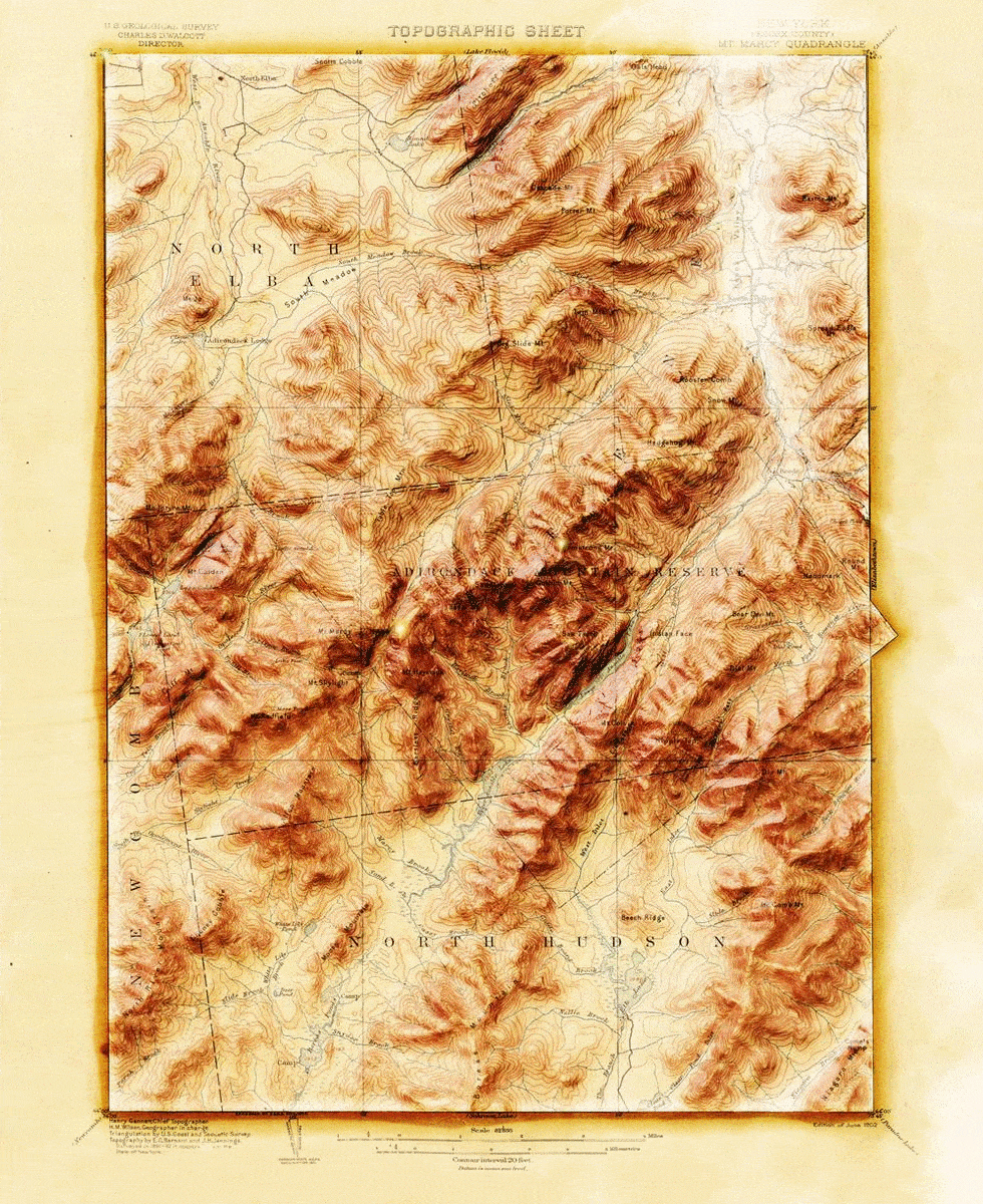
Here is a luscious topographic quadrangle of the Adirondacks printed in 1902 (surveyed in 1892!):

And here it is with some hillshading blended into it…

What’s going on here?! This is one of those things where you take an achingly beautiful vintage topo or geology map and then brew some modern 3D hillshade into it to make it jump off that charmingly yellowed page and find a place right in your geographer’s heart. Old becomes new. A treasured relic of generations past gets new life as an object of joy. All that.
This 3D-ification was done entirely in ArcGIS Pro, and I’m just dying to show you how!
…
Part 1: Georeferencing
0:00 Little bit of map nerd history about these things.
1:27 Where I found this topo quad.
2:22 A bit of appreciation for maps that spill out over the neatline.
3:12 How to pin an image to true geographic coordinates (georeferencing)
4:00 Selecting a similar projection to the topo quad.
5:20 Pinning some georeference control points.
6:11 How to change the coordinate format at the bottom of a map view.
7:54 Awwww yeahhhh a bunch of pixels now know where they live!
8:21 Changing the appearance defaults of an image (gamma, resampling, stretch).
9:12 Bold claims about spatial sentience that I stand by.
9:34 Ok hang on, maybe just try the Living Atlas USGS Historical Topographic Map Explorer!
…
Part 2: Elevation Data
0:00 Skip this re-cap and just dive right in.
0:23 How to use Map Notes to draw quick and convenient new features.
0:58 Drawing in a polygon of the paper extent, and the map extent.
2:22 How to add elevation data from anywhere in the world, at pretty much any scale, from Living Atlas.
2:46 Warren Davison showed me how to steal portions of this Living Atlas elevation!
4:10 How to cookie-cut out a portion of the elevation image to match the map area.
4:58 Using Raster Calculator (Image Analyst license) to add dead pixels outside the map, but inside the paper, to give shadows a place to fall.
6:52 Wordy summary with somewhat awkward and perplexing eyebrow raising.
…
Part 3: Hillshade
0:00 Typical blathering introduction.
0:55 I’ll use the hillshade from Spatial Analyst, or 3D Analyst, licenses because they can cast long shadows. If you don’t have a license you can do 99% of this with the hillshade tool found in Raster Functions.
2:07 Creating a new layout in the good old topo quad dimensions of 22×27 inches.
2:36 Inserting my map frame and fine-tuning its position in the layout.
3:08 Getting rid of that default 1 pixel black border around the map frame.
–time to just play around with stacking up blended hillshade layers–
3:22 Cranking out several hillshade layers, each with a bit different sun angle.
4:15 Blurring the hillshade layers with the Focal Statistics raster function.
4:40 Blend modes (predominantly the Soft Light blend). Ah, glorious blend modes.
4:44 Playing around with adding color into the hillshade color schemes.
6:58 Giving the neatline polygon a gradient stroke to simulate a shadow.
7:42 Bringing in that fun old mist hack!
8:17 Ah the slope raster function! That’s a nice one for next-level hillshading.
9:04 A couple nice crisp hillshades from the raster functions.
10:33 Adding bits of color into the otherwise-grayscale hillshades.
11:50 I like that neatline shadow/highlight effect. So why not double it?
12:33 Inserting a cute little layout graphic with a radial fill to look like a shimmer.
14:11 Exporting the layout as an image.
14:25 Yes! Some before/after snapshots!
14:49 An unexpected 3D version of the map, using the map elevation.
16:50 Yadda yadda, closing chatter. Thanks for following along!
And that is it, my map friends! I know it’s quite a bit of video to slog through but really, once you get rolling with hillshades and blend modes you are just going to tumble down into that rabbit’s hole and just love it. If you try this out of course I’d love to see what you come up with!
Happy 3D Vintage Mapping! John


Article Discussion: