It turns out that the ocean is not too big to fail, unfortunately. The good news is that it’s also not too big to fix.
As Chief Scientist of Esri, Dawn Wright aids in strengthening the scientific foundation for Esri software and services, while also representing Esri to the scientific community.
A specialist in marine geology, geography, and oceanography, Dawn has authored and contributed to some of the most definitive literature on marine GIS. She’s a Fellow of the American Association for the Advancement of Science, the Geological Society of America, the California Academy of Sciences, The Oceanography Society, Stanford University’s Leopold Leadership Program (now known as the Earth Leadership Program), and holds lifetime achievement awards from the American Association of Geographers, the Geological Society of America, and UC Santa Barbara. She was recently elected to the American Academy of Arts & Sciences, as well as being granted the American Association of Geographers 2021 Stanley Brunn Award for Creativity in Geography.
She maintains an affiliated faculty appointment as Professor of Geography and Oceanography in the College of Earth, Ocean, and Atmospheric Sciences at Oregon State University. Dawn holds an Interdisciplinary Ph.D. in Physical Geography and Marine Geology from UC Santa Barbara.
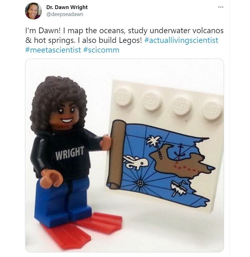
To many, Dawn is also @deepseadawn–a name earned after she became the first black woman in 1991 to dive to the deep ocean floor in Alvin, a deep-sea submersible vehicle. She’s an advocate of GIS, the planet, and inclusivity; passionate about Legos, Star Wars, and her dog Riley; plus, a mentor and hero to aspiring scientists and beyond.
The StoryMaps team recently chatted with Dawn about her own inspiration, the importance of ocean health and mapping, and the 2021 ArcGIS StoryMaps Challenge for Restoring Our Ocean. Read the interview below.

This week Esri and the National Geographic Society are kicking off the 2021 ArcGIS StoryMaps Ocean Challenge–focused on engaging youth in ocean conservation and restoration.
As a guest judge and oceanographer, can you tell us what this challenge means to you?
Growing up in the Hawaiian Islands, I spent endless hours at the beach. I fancied myself one of the characters in Treasure Island, fascinated by the idea of a pirate’s life with liberty, equality and fraternity, held high. I followed imaginary clues and dug for loot in the sands.
By age eight, my path as an ocean geologist was set.
Years later, as Chief Scientist of Esri, I help organizations make the connection between science and location-based data.
More than 80 percent of the ocean floor remains unmapped, yet comprehensive ocean maps will be essential for stemming the problems of overfishing, habitat destruction, pollution, and biodiversity loss. It’s easy, and at this point cliché, to say “save our ocean,” but a data-driven map compels people to see why the ocean needs saving, where to start, and what needs to be done. Seeing the ocean in its true depth and complexity is exactly what we need if we hope to reduce the risk of critically damaging or exhausting marine resources.
So the importance of this challenge to me is that it will bring new ideas and voices into the conversation. It is so very important to engage youth globally in creating data-driven solutions for our ocean and our world. The future is in their hands, so I’m extremely excited that anyone in high school, college, or age 18-24 will be able to submit their ideas in a story built with ArcGIS StoryMaps.
Learn more about Dawn, climate change, and data-driven solutions in her recent interview with the California Academy of Sciences.
Was there someone who mentored or inspired you?
As a seagoing mapper of the ocean floor who started working professionally just as Marie Tharp was finally being recognized for her great scientific accomplishments, her life story is a burning, guiding light for me.
Among my favorite expeditions was to a famous place boldly depicted in one of her stunning panoramas: the East Indian Ocean. It was important to have her map on hand to help me understand the features that we were sampling.

In my view, Marie Tharp literally invented the field of marine cartography. And in terms of the future, given the ubiquity of ships, vehicles, robots, and their accompanying data streams, Tharp’s work continues to show us that mapping technologies need to integrate not only intuitive design but artistic beauty. This ultimately helps us to do the best science.
For the students and young professionals out there, can you share any challenges or barriers you faced as a young oceanographer?
I’ve had many challenging adventures in my life, such as my fieldwork at sea, where I was one of maybe ten women on an oceanographic research vessel occupied by 100. I encountered some men on these expeditions who at first intimidated me. Many of them had never worked in close contact with women before, let alone for two solid months out on the open ocean. But I’ve found that when you give yourself an opportunity to just sit down with people, you can relate. It doesn’t matter what your background is, we’re people and scientists first.

We need more and more women to be educated across the world, including in GIS. We can’t afford to miss out on the perspectives, the sensitivity, the experience of half our population! And we desperately need the perspectives of more people of different cultures and ethnic backgrounds, men and women. We need this to guide our educational programs, our research, our governments and our GIS companies!
Can you tell us about a current partnership or project that brings organizations and people together for ocean science and health?
As the world slowly emerges from the pandemic and enters the United Nations’ Decade of Ocean Science for Sustainable Development, it can do so knowing companies, scientists, and policy makers have the power to make smarter choices for people and the planet.
One of the best ways that we can cope on a global scale is by continuous, near real-time mapping and monitoring of the entire face of the Earth. The Group on Earth Observations or GEO is one of the most comprehensive collaboratives doing just that.
GEO Blue Planet is the coastal and ocean arm of GEO, connecting ocean and coastal information with society. This initiative delivers usable data and information services to support informed decision-making geared toward reaching the United Nations Sustainable Development Goal 14. This SDG is aimed, in part, at reducing the impacts of ocean pollution, particularly from land-based activities such as agricultural runoff.

For educators and youth interested in the 2021 ArcGIS StoryMaps Ocean Challenge, where can they find data, maps, and stories like the Geo Blue Planet and Esri story above?
That’s a great question. And fortunately, Esri hosts scientific data, maps and apps, stories, and more on a few helpful sites, including:
Educators, I highly recommend the Teach with GIS hub created by Sandra Turner. Also a guest judge of the Ocean Challenge, Sandra is a Global Climate Change Education Leader and a National Geographic Certified Educator who teaches aquaculture, climate science, and ocean literacy.

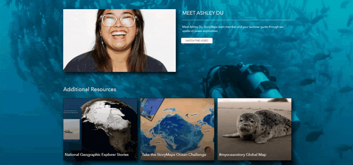
For the challenge specifically, Esri’s StoryMaps team just launched a new #myoceanstory micro-site complete with stories of ocean explorers, GIS and storytelling resources, and helpful bite-sized ocean topics to get you started.
And don’t forget to follow @DeepSeaDawn, @GISandScience, @ArcGISStoryMaps, and @NatGeoEducation on Twitter for challenge updates, ocean resources, and more!

Visit the 2021 ArcGIS StoryMaps Challenge for Restoring Our Ocean page—co-hosted by Esri and the National Geographic Society—for official rules, recognitions, and judges.

Article Discussion: