Today, Earth Day goes digital.
The first Earth Day celebration was held on April 22, 1970…50 years ago! It’s now recognized as the planet’s largest civic event.
This year’s historic Earth Day celebration includes digital events like webinars, environmental films, the Earth Challenge 2020 app, plus more fun and powerful ways to change the world—all safely from your own home and neighborhood.
For Earth Day and beyond, download ten nature-inspired videos, maps, and photos from our story maps as virtual backgrounds for your next meeting or meetup.
Tip: Some video conferencing tools will automatically mirror your background in your personal view (but it will appear normally for others on the call). You can easily turn off this feature so your maps and other backgrounds appear in the proper orientation on your screen.

Videos
A world of forests
Nothing quite says Earth Day like a tree. At local, regional, and global scales, forests play pivotal roles in enabling life to flourish on our planet. But are we caring for them responsibly? A world of forests—the third in the StoryMap team’s Living in the age of humans series—takes on this question and more. The downloadable video shows the fluctuating tree gain and loss over a year.

Birding in Trinidad
Go Birding in Trinidad with Allen Carroll at the Asa Wright Nature Center, a forest wildlife preserve just a few miles off the coast of Venezuela. The Center boasts a dozen hummingbird species and a host of other colorful tropical birds. White-chested emeralds, among the most abundant, seem to enjoy the frequent, torrential rain showers.

Maps
Scraping the heavens
Take a virtual trek through the Tien Shan, Kyrgyzstan’s “celestial mountains,” with Cooper Thomas. In Scraping the heavens, Cooper introduces the landscape with an exaggerated relief map of Kyrgyzstan. As the story unfolds, readers discover the breathtaking mountain views, pastureland, rivers, and waterfalls only hinted at in the map’s shadows.

(Farm) animal planet
If you had to guess, would you say there are more pigs or ducks on Earth? Do you know how many chickens there are per person?
(Farm) animal planet begins with these questions and then examines the ways in which animal domestication is inexorably intertwined with human development—and how our growing demand for animal products has actually reshaped the planet. Our downloadable global density map visualizes the six most common types of livestock—chickens, cattle, ducks, sheep, goats, and pigs—weighted by biomass.

The human reach
The human reach–the first chapter in the Living in the age of humans series–looks at the cumulative “footprint,” or extent, of all human activities around the world. The downloadable human footprint map melds data representing population density, land transformation, accessibility (roads, railroads, rivers, shorelines), and electrical power infrastructure into a single visualization.

Photos
Adventures in astrophotography
Grab your camera and chase the Milky way across the American West with Mark Harrower. His Adventures in astrophotography story features phenomenal night skies while offering helpful photo tips for scoping out the perfect spot—like Gunsight Bay on Lake Powell pictured below. With no roads and no cell signal, boating is the only way in and out of this vast wilderness.

The cherry blossoms of Washington, D.C.
The cherry blossoms of Washington, D.C. tells the fascinating story of how these springtime favorites came to be in the District. Experience the history and beauty at home with our downloadable Tidal Basin photo.

Game drive
Take a morning Game drive through Lake Nakura National Park with Ross Donihue. Experience the wildlife and habitat that inspire conservation and digital storytelling efforts there, like this large white rhino standing guard over a year-old baby.

In the shadow of a volcano
In 2017, Ross Donihue set out on a National Geographic-funded expedition to better understand lands and communities living In the shadow of a volcano. Here the twinkling lights of communities are visible in the pre-dawn view of Santiaguito volcano in Guatemala.

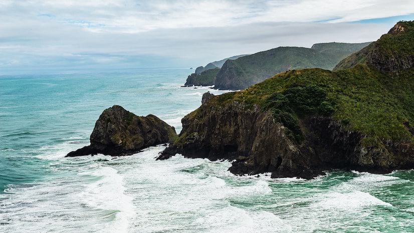
Big Sur sneak peak
Explore the stunning and unique landscape of the central California coast and landscapes of Monterey County. The interplay of fog, ocean, mountains, forest, and grasslands defines this remarkable corner of the world. Keep Mark Harrower’s new Big Sur story map on your radar—scheduled for release next week.

More ways to get involved
Download the Earth Challenge 2020 app and gather climate data. Share an Earth Day poster or favorite EarthPlace. Plus learn more about our planet and its champions.
Get the details in our Earth Day 2020 story collection.


Article Discussion: