2023 Esri User Conference (July 10-14) is right around the corner! The Real-Time team is excited to share a focused agenda covering all activities related to real-time visualization and analytics.
Join Us at the Expo
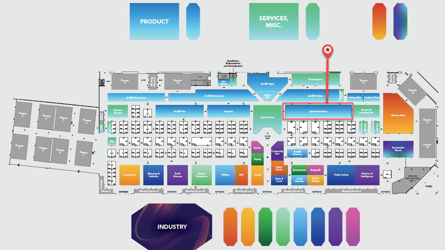
Whether you are interested in seeing the latest updates in ArcGIS Velocity and ArcGIS GeoEvent Server or looking for answers, our experts are available to help! We are located in the Spatial Analytics area (indicated using a red box and location pin) within the Esri showcase. Stop by for a chat!
Showcase Hours
- Tuesday, July 11 | 9 am–6 pm
- Wednesday, July 12 | 9 am–6 pm
- Thursday, July 13 | 9 am–4 pm
Attend the Sessions
Tuesday, July 11
ArcGIS GeoEvent Server: An Introduction
Technical Workshop | 10 am | Room 15 B | In-person, Live stream, Recorded
ArcGIS GeoEvent Server provides real-time visualization and analytics capabilities in ArcGIS Enterprise, enabling organizations to connect with virtually any type of data to derive insights that inform decisions. Join the discussion on how to get started incorporating real-time data feeds with your existing GIS data and IT infrastructure, perform continuous processing and analysis on streaming data with an exploration of filters and processors, and produce new streams of data that work seamlessly across ArcGIS.
ArcGIS Velocity: An Introduction
Technical Workshop| 2.30 pm | Room 16 AB | In-person, Live stream, Recorded
ArcGIS Velocity is a real-time and big data analysis capability in ArcGIS Online. Join the discussion showcasing how to create real-time analytics to detect incidents of interest from continuous streams of events. As real-time data accumulates, learn how to create and schedule big data analytic models to process high-volume historical data and gain insights into patterns, trends, and anomalies. The session will also discuss using stateful Arcade track functions and expressions in your analytics as well as recommendations around choosing the right analysis tools for different scenarios.
Embracing the Era of Transportation with Real-Time Capabilities
Demo Theater | 4 pm | Expo Demo Theater 8 | In-person
With the emergence of real-time data, sensors, and workflows within the transportation discipline; making sense and leveraging real-time capabilities in our everyday can seem overwhelming. In this session, we will present a strategy and explore the GIS solutions that will allow you to integrate real-time capabilities into your work. Whether you are an airport, railroad, public transit agency, local or state department of transportation, or port, you will leave with next steps and best practices that you can take back to your office and apply.
Wednesday, July 12
ArcGIS Velocity: An Introduction
Technical Workshop | 8.30 am | Room 10 | In-person, Recorded
ArcGIS Velocity is a real-time and big data analysis capability in ArcGIS Online. Join the discussion showcasing how to create real-time analytics to detect incidents of interest from continuous streams of events. As real-time data accumulates, learn how to create and schedule big data analytic models to process high-volume historical data and gain insights into patterns, trends, and anomalies. The session will also discuss using stateful Arcade track functions and expressions in your analytics as well as recommendations around choosing the right analysis tools for different scenarios.
Using GIS to Understand Travel Behavior
User Presentation | 8:30 am | Pacific Ballroom 22 | In-person
Comprehensive data and good analysis are key components to planning for future mobility needs. These presentations highlight how GIS can help enrich transportation planning analyses, to help build safer and more equitable networks for the future.
ArcGIS GeoEvent Server: An Introduction
Technical Workshop | 10 am | Room 3 | In-person, Recorded
ArcGIS GeoEvent Server provides real-time visualization and analytics capabilities in ArcGIS Enterprise, enabling organizations to connect with virtually any type of data to derive insights that inform decisions. Join the discussion on how to get started incorporating real-time data feeds with your existing GIS data and IT infrastructure, perform continuous processing and analysis on streaming data with an exploration of filters and processors, and produce new streams of data that work seamlessly across ArcGIS.
ArcGIS Velocity: Stateful Real-Time Analytics with Arcade
Demo Theater | 10 am | Expo Demo Theater 14 | In-person
ArcGIS Velocity now supports the use of stateful Arcade track functions and expressions in your analytics. With these new capabilities, you can build your own stateful expressions in Arcade to solve analytic extension needs. Learn how to access and leverage past observations for each track to make decisions, calculate values, and change geometry. We will demonstrate how to build custom expressions that solve challenges or questions specific to your organizational workflows.
Monitoring and Addressing Real-Time Threats
Demo Theater | 1 pm | Expo Demo Theater 14 | In-person
In today’s increasingly volatile world, having access to real-time information is critical for security professionals to help them protect the people, places, and things they care about. We will discuss how ArcGIS Velocity can be used to monitor and analyze real-time threat information to help improve response time and increase resiliency. We will also demonstrate the use of indoor tracking and reporting to further enhance your security operations.
Snow Fighting with Real-Time GIS
User Presentation | 1 pm | Room 29 B | In-person
Public works agencies that leverage GIS apps are reducing costs and improving productivity and efficiency by applying the technology to optimize their winter weather operations. Attend this session to see how two communities use the latest GIS technology to keep all roads, sidewalks, and city pathways clear of snow in real-time.
Visualizing Live Data in Real-Time Analytics
Demo Theater | 2.30 pm | Expo Demo Theater 9 | In-person
One of the most popular recent enhancements in ArcGIS GeoEvent Server, sampling and visualizing real-time data as it’s processed, is coming to ArcGIS Velocity. Learn how to sample real-time data on any step in your analysis model and understand how different tools are changing the data and applying your tradecraft. We’ll demonstrate how these sampling capabilities work in both GeoEvent Services and Velocity real-time analytics.
ArcGIS Velocity: Applying Real-Time and Big Data Analytics
Technical Workshop | 4 pm | Room 14 A | In-person, Recorded
ArcGIS Velocity is a real-time and big data analysis capability in ArcGIS Online. Join the discussion showcasing how to create real-time analytics to detect incidents of interest from continuous streams of events. As real-time data accumulates, learn how to create and schedule big data analytic models to process high-volume historical data and gain insights into patterns, trends, and anomalies. The session will also discuss using stateful Arcade track functions and expressions in your analytics as well as recommendations around choosing the right analysis tools for different scenarios.
ArcGIS GeoEvent Server: Applying Real-Time Analytics
Technical Workshop | 4 pm | Room 17 A | In-person, Recorded
ArcGIS GeoEvent Server enables you to connect to and analyze virtually any type of streaming data. Push spatial data to web applications, data stores, or automatically alert personnel when specific conditions occur. Join the discussion showcasing how to create GeoEvent Services, configure filters and processors to perform real-time analysis, and identify events of interest. Topics include attribute/spatial (geofence) filtering, geotagging, calculating field values, enriching real-time observations from external data sources, mapping data schemas, and detecting incidents and gaps.
Applying Geospatial Intelligence for Security Operations: From Global to Local to Tactical
Demo Theater | 4 pm | Expo OPS Demo Theater | In-person
Learn how to integrate multi-source information feeds with GIS to support site security, executive protection, threat analysis, investigations, critical event management, and tactical response. Learn how mapping applications, data, and tradecraft come together to help users mitigate, respond to, and recover from crime, threats, and hazards from local to global levels in a secure and interoperable environment. Whether protecting one facility or a global network of physical assets – discover why location intelligence is the proven platform that can unify this complex mission.
Leveraging ArcGIS in Support of Open-Source Intelligence (OSINT)
Demo Theater | 4 pm | Expo Demo Theater 9 | In-person
Military and intelligence agencies are often faced with information gaps that cannot be filled by traditional intelligence functions alone. To fill these gaps, organizations can integrate open-source intelligence (OSINT), which is the practice of collecting and analyzing publicly available data. In this session, attendees will learn how to leverage the ArcGIS system to integrate OSINT data with existing geospatial infrastructure and use analysis to turn open information into actionable intelligence.
Thursday, July 13
ArcGIS GeoEvent Server: Best Practices
Technical Workshop | 8:30 am | Room 30 D | In-person, Recorded
Interested in learning the ins and outs for being successful with the Real-Time Visualization and Analytics capabilities in ArcGIS? Get insight into intermediate and advanced topics for deploying real-time GIS using ArcGIS GeoEvent Server and the spatiotemporal data store, including topics such as recommended architecture, reliability, and scalability. Additionally, learn how to optimize real-time analysis in GeoEvent Server, and how to avoid common “gotchas” in real-time workflows.
Applying Geospatial Intelligence for Security Operations: From Global to Local to Tactical
Demo Theater | 10 am | Expo OPS Demo Theater | In-person
Learn how to integrate multi-source information feeds with GIS to support site security, executive protection, threat analysis, investigations, critical event management, and tactical response. Learn how mapping applications, data, and tradecraft come together to help users mitigate, respond to, and recover from crime, threats, and hazards from local to global levels in a secure and interoperable environment. Whether protecting one facility or a global network of physical assets – discover why location intelligence is the proven platform that can unify this complex mission.
Defining Your Real-Time Data Strategy: A Brief Overview
Expo Spotlight Talk | 10 am | Expo Implementation Spotlight Theater | In-person
How should your organization approach the capture, analysis and storage of real time data? Which patterns help set you up for repeatable, rapid analysis, and allow you to properly manage an archive of observations? This presentation will cover the process of planning for a real time GIS system and some of the various options that are available for managing data, feeds, analytics and storage.
ArcGIS GeoEvent Server: Applying Real-Time Analytics
Technical Workshop | 1 pm | Room 5 A | In-person, Recorded
ArcGIS GeoEvent Server enables you to connect to and analyze virtually any type of streaming data. Push spatial data to web applications, data stores, or automatically alert personnel when specific conditions occur. Join the discussion showcasing how to create GeoEvent Services, configure filters and processors to perform real-time analysis, and identify events of interest. Topics include attribute/spatial (geofence) filtering, geotagging, calculating field values, enriching real-time observations from external data sources, mapping data schemas, and detecting incidents and gaps.
Public Safety GIS for Executive Protection and Travel Risk
Demo Theater | 1 pm | Expo Demo Theater 14 | In-person
Today, there is a heightened need and expectation to provide security to executives, employees and prominent public officials. The responsibility is more than sunglasses and suits; it is an ecosystem of advance work, logistics, threat assessment and real-time awareness. By facilitating the immediate delivery of information, we can better communicate potential hazards and keep our people safe. It is the power of key information & communication at your fingertips, all with a goal of not only protecting personnel but preserving the confidence of the community, employees and investors.
Friday, July 14
ArcGIS Velocity: Applying Real-Time and Big Data Analytics
Technical Workshop | 9 am | Room 9 | In-person, Recorded
ArcGIS Velocity is a real-time and big data analysis capability in ArcGIS Online. Join the discussion showcasing how to create real-time analytics to detect incidents of interest from continuous streams of events. As real-time data accumulates, learn how to create and schedule big data analytic models to process high-volume historical data and gain insights into patterns, trends, and anomalies. The session will also discuss using stateful Arcade track functions and expressions in your analytics as well as recommendations around choosing the right analysis tools for different scenarios.
Resources
Note that the UC Event Map is now available to allow you to get familiar with the convention center and view locations of sessions and activities before you go to San Diego. You can also generate a route and directions between two locations and view the estimated travel time. Use this map along with the Detailed Agenda and My Schedule for planning your UC experience. The map will also be available in the Esri Events App and at directory kiosks on site in the convention center. Learn more.
Here are a few additional resources:
- ArcGIS Velocity product information, resources, what’s new in June 2023, and user community
- ArcGIS GeoEvent Server product information, what’s new, and user community
- Read about our real-time data providers and sources
See you in San Diego!


Article Discussion: