Updated November 2024
The oriented imagery capability of ArcGIS enables you to manage, visualize, and explore a wider array of image types in the context of a map, including collections of high oblique drone images, close-range inspection images, street-level images, and images taken by mobile devices. First integrated into the October 2023 release of ArcGIS Online, ArcGIS Pro 3.2, and ArcGIS Enterprise 11.2, you can now seamlessly bring these new imagery formats into your GIS.
Learn more about what’s new in oriented imagery:
- ArcGIS Pro 3.4, ArcGIS Online (November 2024), & ArcGIS Enterprise 11.4: visualize 360 imagery in Pro, overlay feature layers in imagery in Online, and create 3D oriented imagery web apps
- ArcGIS Online (February 2024): visualize 360 imagery, create an oriented imagery app, ArcGIS QuickCapture support
- ArcGIS Online (October 2023), ArcGIS Pro 3.2, and ArcGIS Enterprise 11.2: the initial release of the oriented imagery capability
Read on to learn more about…
- How the oriented imagery capability fits into the ArcGIS system
- Troubleshooting the oriented imagery workflow in ArcGIS
- Transitioning from Oriented Imagery Classic to the integrated oriented imagery capability
Do you have questions we haven’t answered here? Visit us at the Esri Community page for Oriented Imagery and share your thoughts.
The big picture
Learn more about what the oriented imagery capability is and how it fits into the ArcGIS system.
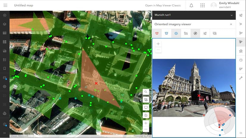
What are “oriented images”?
Oriented images are images with associated location, orientation, and camera metadata that are used to relate pixels in an image to locations on a map (and vice versa). This includes images that can’t be rectified using traditional photogrammetric solutions, like street-level images, images from mobile devices, close-range inspection images, and high oblique images. (It can also include nadir and low oblique images, though those can also be managed, visualized and analyzed in ArcGIS using existing methods). Oriented imagery can include images collected from many different kinds of platforms with a variety of view angles, including drones, airplanes, terrestrial vehicles (like cars or buses), handheld devices, or even tripods.
Is oriented imagery a part of ArcGIS Reality?
Both the oriented imagery capability and ArcGIS Reality products generate accurate digital representations of the real world using images and geospatial data, also known as “reality mapping.” However, they serve different purposes, which can sometimes be used jointly.
With ArcGIS Reality, you can create authoritative 2D and 3D data products, such as True Orthos and 3D meshes, at virtually any scale. These products are generated from large collections of overlapping still images captured by drones, airplanes or satellites.
Sometimes you don’t need a True Ortho or 3D data products, or you already have them. Perhaps the images you have aren’t captured with the necessary overlap required to process them using ArcGIS Reality. Or, you need only a few images and want to view them in their full original resolution.
The oriented imagery capability provides the ability to manage, query, and visualize collections of individual images (overlapping or not), captured indoors, from the ground, or from the air, and visualize those individual images in geospatial context.
Used together, they can provide an extremely detailed view of what’s happening on the ground, supporting inspection and providing you remote intelligence about areas or objects of interest so you can make informed decisions.
I have drone imagery—when should I use oriented imagery?
Oriented imagery might be a good option for visualizing your drone images if your imagery collection doesn’t support the block adjustment required to generate products with ArcGIS Reality. This could mean an image collection that:
- Contains images that include the horizon (or are angled up above the horizon)
- Doesn’t contain enough images or the images don’t have enough overlap
- Contains images that are very close up (like for inspections)
In these cases, the oriented imagery capability provides an alternative to orthorectification for relating the images to the map/ground. It uses information like the location and orientation of the camera, the camera’s horizontal and vertical fields of view, and a digital elevation model (DEM) that defines the ground to relate each pixel in an image to a location on a map (and vice versa).
Instead of visualizing the images directly on a map, the user clicks on a point of interest on the map, then views the best image of that location in the oriented imagery viewer, with the image’s footprint dynamically updated on the map as the user pans and zooms in the image.
Additionally, you may want to supplement your ArcGIS Reality products with oriented images—for example, to document small changes that don’t warrant re-processing your 3D mesh. If, for example, a solar panel was repaired and you’d like to document the work with drone images, being able to use the oriented imagery capability to manage and visualize the updated images in the context of your ArcGIS Reality products could be a useful option.
For nadir or low oblique imagery, it seems like I could use either the mosaic dataset/image service data model, or the oriented imagery data model. What should I do?
Assuming you have the minimum required metadata for your images, it’s possible to manage and visualize any type of imagery using the oriented imagery data model.
For nadir and low oblique images, though, mosaic datasets, image services, and dynamic imagery layers (not to mention tiled imagery layers) offer a variety of features, including the ability to display images directly on the map or scene in an intuitive way, and the option to use raster functions to perform on-the-fly processing and analysis.
However, if you don’t have ArcGIS Image Server or ArcGIS Image for ArcGIS Online, and you don’t need the advanced functionality enabled by the mosaic dataset/image service data model, then the oriented imagery data model might make sense for managing and visualizing nadir and low-oblique images in the context of a map.
 and those supported by mosaic datasets (including satellite, aerial imagery, and nadir or low oblique drone images).")
Troubleshooting the oriented imagery workflow
Find guidance on common questions users face when working with the oriented imagery capability of ArcGIS.
Why isn’t the Image Gallery tool available in the oriented imagery viewer?
The Image Gallery tool is intended to show quick-loading, low resolution thumbnails of your images. This is supported for image formats that have internal tiling, like TIF or MRF (this ensures lower resolution versions of the images are available to display). It is not supported for JPEG image files, which don’t have internal tiling. If you want to enable the Image Gallery tool for JPEG images, you’ll need to convert them to MRF or TIF format. Note that MRF is only supported if it’s hosted in the cloud.
How can I keep my data secure if it’s in public cloud storage?
You have a few options to make images in public cloud storage more secure.
First, you can obfuscate file names. This means that the file names are randomized, so there’s no predictable pattern to them. Obfuscation ensures that if someone has the path to one file, they can’t guess the paths of the rest of your files based on the pattern of the file path.
Second, you can remove list permissions on your bucket, so a random person can’t generate a list of all the files in the bucket. This ensures that users can’t easily discover the paths to all the files in the bucket at once.
Third, you can configure security protocols (like AWS bucket policies) to restrict access to specific IP addresses or a range of IP addresses.
In future releases, we’ll offer more options for hosting your images securely, including support for hosting images as feature attachments to your oriented imagery layer.
Will oriented imagery work in a disconnected environment?
Not in ArcGIS Pro 3.2, though we’re working to enable this in an upcoming release. In Pro 3.2, you’ll need internet access to load the oriented imagery widget from the ArcGIS Maps SDK for JavaScript.
Can I filter an oriented imagery layer in ArcGIS Online?
Yes! With the June 2024 release of ArcGIS Online, and the release of ArcGIS Pro 3.4, you can apply a definition query (Pro) or a filter (Online) to an oriented imagery layer, and the oriented imagery viewer will honor it when you click on the map to explore your images. (Note that filters that only impact visibility of features, like the time slider or the visibility range, will not be honored by the oriented imagery viewer.)
Transitioning from Oriented Imagery Classic
Oriented Imagery (now Oriented Imagery Classic) has been available for years as a community-supported, add-in experience for ArcGIS. Now that we’re integrating the oriented imagery capability into ArcGIS products, we want to make sure users of Oriented Imagery Classic understand the roadmap ahead, the differences and similarities between Classic and the integrated capability, and have a plan to transition from Classic to the integrated capability when the time comes.
What are the benefits of the integration?
Benefits include:
- Tighter integration and more seamless interaction with other ArcGIS capabilities and applications (no add-ins or downloads required).
- The ability to leverage widely used ArcGIS patterns for working with operational layers. You’ll be able to add the layer to a map, apply filters, configure symbology, and more.
- Full technical support by Esri (as opposed to the community-supported status of Oriented Imagery Classic)
- A long-term commitment to future enhancements and new features
The roadmap ahead
Learn more about the plan for transitioning from Oriented Imagery Classic to the integrated oriented imagery capability.
When will Oriented Imagery Classic be retired?
Once the integrated oriented imagery capability approaches parity with Oriented Imagery Classic (expected toward the end of 2025), we will announce a concrete timeline for retiring Oriented Imagery Classic. Though it’s difficult to project so far in advance, Oriented Imagery Classic will likely be retired sometime in 2026.
What can I do now with the integrated oriented imagery capability? When will the integrated version of oriented imagery have all the features of Oriented Imagery Classic?
You can use ArcGIS Pro 3.2+ to manage your images as an oriented imagery dataset, add the oriented imagery dataset to a map as an oriented imagery layer, and visualize your oriented images using the oriented imagery viewer and oriented imagery ribbon tools. You can then share the oriented imagery layer to ArcGIS Online or ArcGIS Enterprise 11.2+, and view the published oriented imagery layer in ArcGIS Pro or Map Viewer. All clients currently support frame images, stored locally (Pro only) or in public cloud storage, using JPEG/JPG, TIFF/COG, or MRF formats (MRF is only supported when hosted in the cloud). Visualize them using the oriented imagery viewer in the context of a 2D map in ArcGIS Pro, Map Viewer, and ArcGIS Excalibur.
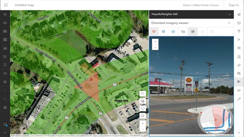
As of the February 2024 release of ArcGIS Online (and ArcGIS Enterprise 11.3), you can also visualize equirectangular 360-degree images and panoramic images in JPEG format. You can create oriented imagery apps using ArcGIS Instant apps (the Sidebar template). And you can use ArcGIS QuickCapture to collect images with your phone or tablet and automatically manage them as an oriented imagery layer.
ArcGIS Pro 3.3 introduced 3D scene support, allowing you to visualize full-resolution images in the context of a 3D mesh, point cloud, or other 3D data; the option to upload images as feature attachments when you publish an oriented imagery layer; and the ability to streamline the oriented imagery management process when using complex metadata formats by defining a custom input type.
The June 2024 release of ArcGIS Online (and ArcGIS Enterprise 11.4) added support for visualizing oriented imagery layers in the context of a 3D scene to the ArcGIS Maps SDK for JavaScript (which you can use to build custom web apps), and a tool to show the popup for the current image.
ArcGIS Pro 3.4 added support for 360-degree and panoramic images, improvements to the Add Images to Oriented Imagery Dataset GP tool, oriented imagery layer support in the Detect Objects Using Deep Learning GP tool, enhancements to the oriented imagery schema, floor filter support, and support for local MRFs
ArcGIS Online (November 2024) introduced feature overlays, which allow you to project vector data into the oriented imagery viewer; and the ability to publish web scenes with oriented imagery layers using Scene Viewer, then create a 3D oriented imagery web app using the ArcGIS Instant Apps 3D Viewer template.

We plan to continue adding the features you know and love from Oriented Imagery Classic throughout 2025, including support for:
- Additional imagery types, including video and 360-degree video
- Additional image hosting options, including options for secure image storage.
- Advanced visualization tools, including measurement, the ability to overlay vector data on your imagery (already supported in ArcGIS Online!), and the option to digitize features in the oriented imagery viewer
- An oriented imagery widget in ArcGIS Experience Builder.
Should I transition to the integrated version of oriented imagery?
It depends on the features you need! For some users, their must-have features have already been integrated into ArcGIS; they are encouraged to start the migration now. For others, they may need to wait until their key features (like an Experience Builder widget or digitization) are available in ArcGIS. Classic users are encouraged to explore the integrated capability to understand how it works and what’s available. Once your key oriented imagery requirements are integrated, you can begin migrating to the core oriented imagery capability. At the latest, current Oriented Imagery Classic users can continue using their established Classic workflows until Classic is retired in 2026.
Note that after February 2024, no new features will be added to Oriented Imagery Classic.
Once the integrated capability approaches parity with Classic, we’ll ask that you start converting your oriented imagery catalogs to oriented imagery layers, and converting any Classic workflows you rely on to the new oriented imagery capability if you haven’t already. This may mean recreating Experience Builder apps, or revising scripts you use for automation.
Early in 2025, Esri plans to provide a tool to convert an oriented imagery catalog published to ArcGIS Online or ArcGIS Enterprise to a new oriented imagery layer item, which can then be consumed using the integrated oriented imagery capability.
Oriented Imagery Classic components
Learn more about the integrated oriented imagery capability’s answer to the various components of Oriented Imagery Classic.
Will oriented imagery catalogs still work with the integrated oriented imagery capability?
No. Oriented imagery catalogs will be replaced by oriented imagery datasets and oriented imagery layers. The underlying schema is very similar, but oriented imagery datasets and layers will be supported natively by ArcGIS, which means they’ll be more robust and play nicely with other parts of the software. We’ll have tools available later this year for you to convert your existing oriented imagery catalogs to oriented imagery layer items in ArcGIS Online or ArcGIS Enterprise.
What’s going to happen to the Oriented Imagery Viewer?
Map Viewer (and eventually Scene Viewer) will replace the Oriented Imagery Viewer.
With the October release of ArcGIS Online and ArcGIS Enterprise 11.2, oriented imagery layer support and the oriented imagery viewer are built into Map Viewer. This means you can add an oriented imagery layer to a web map and visualize it using the oriented imagery viewer. You can save and share web maps that contain oriented imagery layers. We plan to introduce similar support for oriented imagery layers to Scene Viewer in an upcoming release.
The Oriented Imagery Viewer was originally built because oriented imagery catalogs were not supported by Map Viewer or Scene Viewer—Oriented Imagery Viewer offered an alternative to visualize and share oriented imagery catalogs on the web. With the integration, you’ll be able to use the Map Viewer (and eventually Scene Viewer) to visualize and explore oriented imagery layers just like any other layer type.
Will the current Experience Builder widget support oriented imagery layers?
No. The current Experience Builder widget will become the Oriented Imagery Classic widget, and will only support oriented imagery catalogs.
We plan to introduce a new Oriented Imagery widget in early 2025 that will be designed to work with oriented imagery layers, and will be built using the oriented imagery viewer widget that’s part of the ArcGIS Maps SDK for JavaScript.
It is possible to create an oriented imagery app using the ArcGIS Instant Apps sidebar template or the 3D Viewer template in ArcGIS Online.
Will I still need the Oriented Imagery add-in and the Oriented Imagery Management tools to work with the integrated oriented imagery capability?
No. ArcGIS Pro 3.2+ includes an integrated version of the oriented imagery viewer and Oriented Imagery toolset. Use the Oriented Imagery toolset to author an oriented imagery dataset, which can be added to a map or scene as an oriented imagery layer. You can then visualize the images using the oriented imagery viewer and the oriented imagery ribbon tools in ArcGIS Pro. The layer can be shared to ArcGIS Online or ArcGIS Enterprise 11.2 using the standard Pro sharing workflow or the Generate Service From Oriented Imagery Dataset (introduced in Pro 3.4). Once hosted, the oriented imagery layer can be shared with additional users, and visualized using the oriented imagery viewer in Map Viewer, ArcGIS Pro, ArcGIS Excalibur, or an app built with the 3D Viewer or Sidebar templates.
Can I create oriented imagery layers using ArcGIS QuickCapture?
Yes! ArcGIS QuickCapture has added the option to create an oriented imagery layer. Additionally, you still have the option to create and maintain an oriented imagery catalog. Learn more about QuickCapture support for oriented imagery layers.
I want to develop or maintain custom oriented imagery apps—what’s the plan for the Oriented Imagery API?
For developers who are already working with oriented imagery layers, the oriented imagery viewer widget is available as part of the ArcGIS Maps SDK for JavaScript, and can be used to build custom oriented imagery apps.
The Oriented Imagery API, hosted by the Oriented Imagery team, will be maintained until Oriented Imagery Classic is officially retired. New features will generally be limited to the integrated oriented imagery capability.


How will the filter work? Will it be possible to filter by floor like in a floor-aware map?