Imagery is most valuable when you can use it throughout your work, not only in specialized applications or isolated workflows. The November 2026 releases bring updates across the three ArcGIS foundational products:
- ArcGIS Online available on November 9
- ArcGIS Pro available on November 17
- and ArcGIS Enterprise (Windows/Linux) available on November 17
Across these releases, you’ll find new ways to access, manage, visualize, and analyze imagery, video, and reality mapping data as part of your Geographic Information Systems (GIS) workflows. You can also connect imagery with other enterprise systems and work in the deployment environment that meets your needs.
Here’s a look at the new imagery and remote sensing capabilities.
Extend Imagery Across the Enterprise
Introducing ArcGIS Reality Server
Available with ArcGIS Enterprise. Reality mapping can transform large collections of drone, aerial, and satellite imagery into highly detailed representations of the world. But making that processing capacity available at scale is critical for reality mapping to support work across your organization rather than individual projects or users.
ArcGIS Reality Server is a new optional capability server for ArcGIS Enterprise on Windows and Linux. It enables you to perform reality mapping within your own infrastructure and produce photorealistic foundational content, including true orthos and 3D meshes, from drone, aerial, and satellite imagery.
This gives you a self-hosted option for scaling reality mapping while maintaining control over where processing occurs and how the resulting content is managed.
Secure Hosting of Ground Level and Oblique Imagery
Available in ArcGIS Enterprise, ArcGIS Image Server, and ArcGIS Video Server. The perspective you need about an area of interest depends on the work you’re doing. Aerial and satellite imagery provide valuable views from above, while ground-level and oblique imagery let you see assets, infrastructure, buildings, and surrounding conditions from different angles and, in many cases, in greater detail. Captured from drones, vehicles, mobile devices, and other cameras, using ground-level imagery expands how you can view and understand the places you work with in your GIS.
ArcGIS now allows you to store ground-level and oblique imagery in private cloud environments while maintaining your security and governance controls. This expands your options for securely managing and using this imagery across ArcGIS Enterprise, ArcGIS Image Server, and ArcGIS Video Server.
ArcGIS Enterprise Supports Content Store for ArcGIS
Available in ArcGIS Enterprise and Content Store for ArcGIS. Commercial imagery can provide timely, authoritative data for a wide range of GIS workflows, and its value grows when you can make it available to the people across your organization who need it.
Content Store for ArcGIS now supports ArcGIS Enterprise, enabling you to discover and purchase commercial imagery and make it available directly within your Enterprise organization. With support across ArcGIS Online and ArcGIS Enterprise, you can bring commercial imagery to more users and more GIS workflows, regardless of which environment they work in.
Use the Google Photorealistic 3D Basemap in ArcGIS Enterprise
Available in ArcGIS Enterprise. Google Photorealistic 3D Basemap gives you access to Google’s extensive collection of high-resolution, photorealistic 3D content directly in ArcGIS. You can use this ready-to-use basemap to add realistic context to your own GIS data and explore places, infrastructure, and the built and natural environment in 3D.
Previously available in ArcGIS Online, Google Photorealistic 3D Basemap is now available as a preview in ArcGIS Enterprise, extending access to users working in Enterprise environments.
Item Details Assistant
Available in ArcGIS Enterprise portal. Being able to quickly understand what imagery is available helps you find the right content for your work and determine how you can use it. Descriptions, summaries, and other item details provide that context, and making them easier to create helps keep imagery discoverable across your organization.
The new item details assistant in the ArcGIS Enterprise portal helps you generate metadata for imagery layer items. This reduces the effort required to document your imagery and helps others more easily find, understand, and use it.
This short video shows the Item Details Assistant generating information about an imagery layer to help people more easily find, understand, and use it, one way ArcGIS is making imagery more accessible across enterprise organizations.
Accelerate Analysis for Areas of Interest
Imagery and remotely sensed data can reveal patterns, relationships, and changes that help you better understand an area of interest. New and expanded analysis capabilities across ArcGIS give you more ways to uncover that information, apply specialized workflows, and share what you learn with others.
New Charts to Visualize Imagery Data
Available in ArcGIS Enterprise. Earlier this year, ArcGIS Online introduced the ability to create charts from web imagery layers, giving you a new way to explore patterns and relationships in your imagery data. Now, ArcGIS Enterprise brings that capability to Enterprise environments, enabling you to create bar charts, histograms, and scatter plots from imagery layers. These charts help you reveal and communicate patterns and relationships in your imagery that may not be apparent from the imagery alone.
Custom Raster Functions
Available in ArcGIS Enterprise. Raster function templates (RFTs) in ArcGIS allow you to chain together a series of imagery processing and analysis tasks into a repeatable workflow. Instead of performing each step individually, you can save the workflow and apply it to other imagery or share it with others.
You can now create and publish custom raster function templates in ArcGIS Enterprise, making specialized imagery processing and analysis workflows reusable across your organization. Previously available in ArcGIS Enterprise on Kubernetes, this capability is now also available on Windows and Linux, helping you standardize workflows and make specialized analysis available more broadly.
Imagery Source Traceability
Available in ArcGIS Excalibur for ArcGIS Online and ArcGIS Enterprise. Knowing which image or video an observation came from provides important context for verifying and using the information you collect.
In ArcGIS Excalibur, you can identify an object, activity, or area of interest in imagery or video and add it as an observation. Now, when you create that observation, ArcGIS Excalibur automatically records information from the source image or video. This creates a reliable connection between the observation and its source while reducing the time you spend documenting that information manually.
Additional Hyperspectral Data Analysis Tools
Available in ArcGIS Excalibur and Map Viewer for ArcGIS Enterprise and ArcGIS Online. Using hyperspectral imagery in ArcGIS can reveal information beyond what you can see with the human eye, helping you identify materials, detect subtle differences, and better understand conditions in an area of interest.
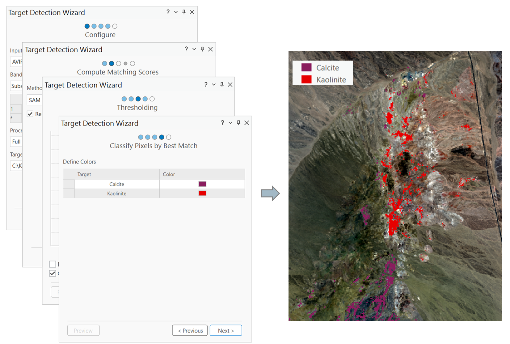
New analysis tools in Map Viewer and ArcGIS Excalibur enable you to detect anomalies and identify targets in an area of interest using hyperspectral imagery. By bringing advanced hyperspectral analysis into web and analysis-ready enterprise environments, work that previously required specialized desktop software can now be performed in more ways.
The introduction of new hyperspectral analysis tools is one way that ArcGIS is helping you to accelerate your image analysis. This video demonstrates how you can identify targets within an area of interest. Data source: NASA/JPL AVIRIS. Presenter: Shengan Zhan from Esri.
Gain More Insight from Additional Sensor Data
ArcGIS continues to expand support for new and emerging sensors, giving organizations access to more imagery and remote sensing data so they can apply proven workflows across a broader range of operational, environmental, and analytic use cases.
PALSAR-2 and PALSAR-3
Available in ArcGIS Image Analyst for ArcGIS Pro. PALSAR-2 and PALSAR-3 are satellite-based synthetic aperture radar (SAR) sensors that collect L-band radar data, giving you a different way to observe and understand conditions on the ground.
With the latest release of ArcGIS Pro, you can use PALSAR-2 and PALSAR-3 imagery in ArcGIS Image Analyst. L-band SAR can reveal information beneath vegetation and provide valuable observations about conditions where other imagery sources may be limited, giving you additional insight for environmental monitoring, agriculture, archaeology, and land management.
AVIRIS-3 and AVIRIS-5
Available in ArcGIS Image Analyst for ArcGIS Pro. AVIRIS-3 and AVIRIS-5 are airborne hyperspectral sensors that collect spectral information across hundreds of wavelengths, allowing you to detect characteristics that aren’t visible to the human eye.
With the latest release of ArcGIS Pro, you can use AVIRIS-3 and AVIRIS-5 imagery in ArcGIS Image Analyst to identify materials, detect change, and gain deeper insight into an area of interest for applications such as environmental monitoring, natural resource management, agriculture, and research.
See and Understand Areas of Interest from More Perspectives
New Operational Workflows
Scene Viewer Integration
Available in ArcGIS Online. Viewing ground-level and oblique imagery within a 3D scene helps you understand photographic detail in the context of the surrounding environment.
You can now access and visualize ground-level and oblique images while exploring a 3D scene in Scene Viewer. You can move between images, take measurements, and compare photographic detail with the surrounding 3D environment, giving you more ways to explore an area of interest for inspections, investigations, and other workflows.
The latest releases of ArcGIS introduces new ways to make ground-level and oblique imagery integral to your GIS work. This short video shows how you can view ground-level imagery in Scene Viewer in the context of a 3D scene.
Leverage the Power of Video in Your GIS
Video gives you a continuous view of an area of interest, capturing movement, activity, and change as it happens from perspectives that add context to other GIS data. New capabilities in ArcGIS make it easier to find and use relevant video and put the information captured with it to work in your GIS workflows.
Drone Video Telemetry Support
Available in ArcGIS Pro. The flight information captured with drone video adds valuable context about where the camera was, where it was looking, and how it was moving when the video was recorded.
Many drone platforms record location, altitude, direction, and other flight information alongside video in SubRip Subtitle (SRT) files, but organizations often need additional processing to make that information usable within their GIS workflows. ArcGIS Pro can now automatically read this information from supported drone platforms and use it to geospatially enable video. This reduces manual processing and helps organizations move more quickly from video collection to mapping, analysis, and operational workflows.
Search Specific Sites for Video
Available in ArcGIS Excalibur for ArcGIS Online and ArcGIS Enterprise. As video collections grow, being able to quickly find footage from the location and time you’re interested in helps you put more of that video to use.
New site-level search capabilities allow users to find relevant geospatial video files using location, time, and metadata, eliminating the need to manually search across individual services. This helps analysts discover available coverage more quickly and get greater value from existing video archives.
With ArcGIS Excalibur, you can now search an area of interest to find corresponding videos, making it easier to incorporate video into your GIS workflows. Demo by Esri’s Tom Merhige.
Discover More Ways to See, Understand, and Apply Imagery to Your Work
The November 2026 releases give you more ways to work with imagery and remote sensing data across ArcGIS. You can bring more data sources into your workflows, see areas of interest from different perspectives, scale reality mapping across your organization, extend advanced analysis to more people, and connect imagery and video with the geographic context that makes them more useful.
Whether you’re working with satellite, aerial, ground-level, hyperspectral, radar, or video data, these updates expand how you can access, manage, analyze, and use that information in your GIS.

Article Discussion: