Have you ever considered the planning that goes behind Election Day? The level of preparation involved in voter registration, ballot distribution, and polling location assignment can pose a significant operational challenge for communities. Location-based technology streamlines all the work elections require, as geography is the common denominator of where voters live, how residents engage in the voting process, and how officials manage elections. ArcGIS Geocoding provides organizations with the tools needed to manage voter address data, assign precise polling locations communities need, ensure transparency, and perform accurate post-election analysis.
Accurate Voter Registration & Address Validation
Address validation ensures voter ballots, and election information goes to the right constituent. This is needed to reduce the number of returned mail , ensure there are fewer provisional ballots caused by address discrepancies, and confirm voter addresses exist, are complete, and are validated When working with large databases like these, organizations rely on tools that provide comprehensive address validation. Address validation involves comparing an observed address against a trusted reference database, ensuring accuracy and usability. Esri’s geocoding capabilities build on this process by matching observed addresses to authoritative reference data, preparing them for deeper analysis.
A common challenge organizations face when validating addresses is identifying how many units are within a particular building. ArcGIS Geocoding’s searchWithin capability returns a collection of associated places or unit numbers for a specific location in addition to the address point. This collection of known addresses in the reference data set makes it easy to match an address or sub-address in a building. When combined with Match Narrative and Match ID users are provided with the details needed to validate these addresses. A Match ID identifies the address match while Match Narrative codes provide a detailed explanation of how that address was matched. This explanation allows users to validate the results as Match Narrative allows them to see which address components matched exactly, partially, through aliases, spelling corrections, and so on. Match Narrative quickly provides context into how the addresses are processed and classified and how closely they align to authoritative data sets. This capability gives organizations the address validation needed to maintain confidence in their voter registration data. Learn more about address validation here.
Election Operations & Logistics
Have you ever gone to vote and were discouraged due to long lines wrapping around the polling location? Extensive wait times can be daunting for voters and may even influence whether they vote in the next election cycle. This is an important consideration in election planning, as it involves coordinating staff and volunteers, assigning equipment, addressing accessibility needs, and determining ballot quantities based on voter density.
ArcGIS Geocoding results provide the necessary set of organized addresses to help election offices verify where voters live so they can accurately set up polling locations. Identifying and prioritizing underserved or high-density voter areas by analyzing travel distance from voter registrations.
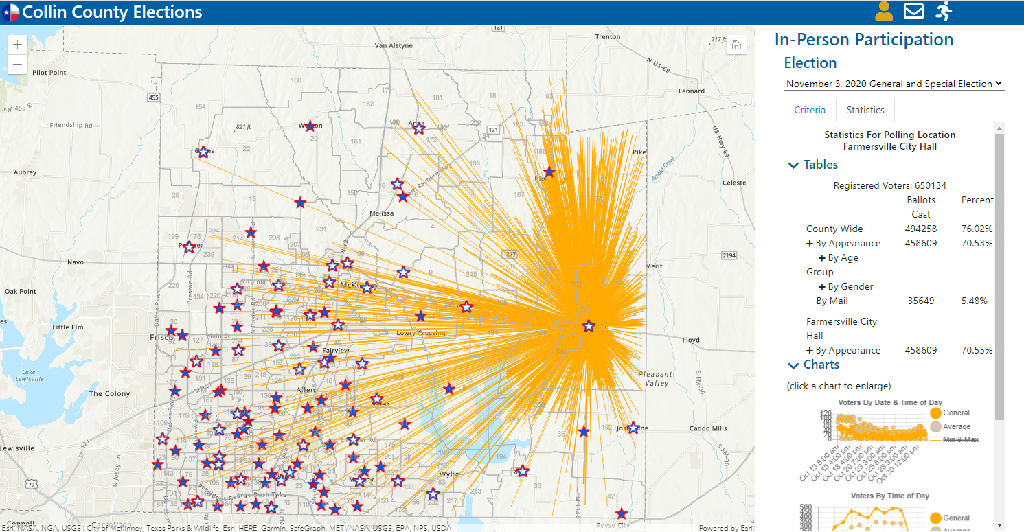
Take Collin County, Texas for example, the county had realized that in previous elections some of their voting centers were overflowing with people while others were practically empty. Wanting to improve the voting experience, Collin County geocoded their voting centers and placed them on a web app so citizens could easily find the nearest polling location with the shortest wait time via a web page or on their mobile devices. This app received nearly 90,000 page views, proving that this geocoded app was solving a real need for the residents. In the end, the app generated 110,000 routes resulting in the highest early voting turnout in the state of Texas.
Transparency, Auditability & Public Trust
Failures in election operations and logistics can quickly undermine public trust in the administration. ArcGIS Geocoding supports transparent elections by providing an authoritative, location-based foundation for critical election processes. By accurately validating and standardizing voter addresses, election officials can ensure voters are assigned to the correct polling locations, ultimately reducing errors and ambiguity that can undermine trust.
Geocoding also enables consistent analysis of polling accessibility, travel distance, and voter distribution, helping agencies clearly explain how locations are selected, and resources are allocated. When address data, precinct boundaries, and polling sites are mapped with precision, election decisions become easier to audit, communicate, and defend, reinforcing public confidence in fair and open election administration.
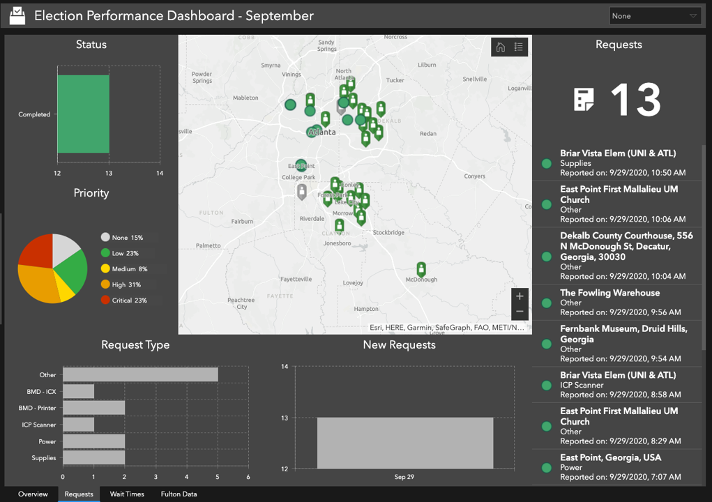
The Elections Division of Georgia’s Secretary of State’s office was looking to reduce errors and maintain the public’s trust when they turned to GIS. Geocoding their polling locations allowed them to deploy an election performance dashboard. The election performance dashboard helps staff from the Secretary of State’s office monitor the overall status of the assistance requests each voting location submits. Allowing them to see which types of requests are being submitted along with their priority level. Having this level of situational awareness allows governments to run smooth elections, reinforcing the public’s trust.
Election Analysis & Reporting
ArcGIS Geocoding plays a critical role in the analysis of the election lifecycle and reporting by ensuring election results are grounded in accurate, location-based data. By linking voter records, turnout data, and ballot results to standardized addresses and geographies, election officials can confidently analyze participation by precinct, district, or community. ArcGIS Geocoding helps generate accurate address data for clear visualization of turnout patterns, identification of geographic disparities, and validation of results against official boundaries, making findings easier to audit, explain, and report to stakeholders.
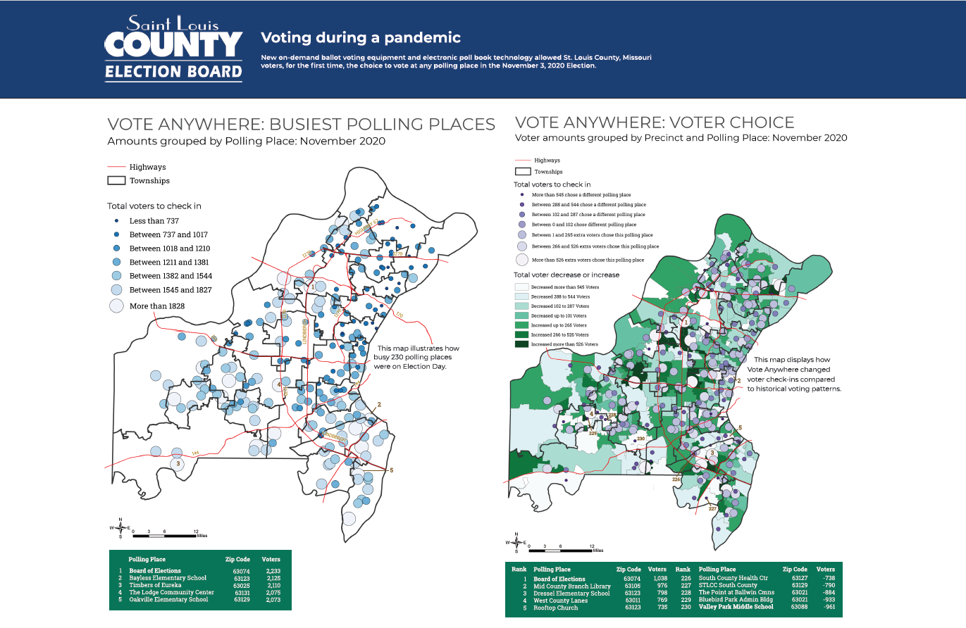
For example, St. Louis, Missouri wanted to ensure that year over year they were improving their elections. So, they started by geocoding their polling locations, identified the busiest voting centers, and analyzed how they could plan for future polling locations to enhance the voting experience.
These use cases illustrate how ArcGIS geocoding helps elections run accurately, fairly, and efficiently by ensuring every voter is linked to the right polling location. Address validation is essential for election operations and planning as it improves data accuracy, improves operational efficiency, and in the end improves voter experience. By building an election management system powered by ArcGIS Geocoding, organizations can more accurately validate and maintain voter and address data, uncover issues that were previously hidden, prioritize assistance requests, and identify voter trends and patterns.
For more information
Take a look at how you can Reimagine the election process with ArcGIS Geocoding. Or access our recent elections webinar recording to learn from Esri experts directly.




Commenting is not enabled for this article.