The City of Plano, Texas, paired Esri’s ArcGIS with OpenGov’s asset management software to meet the Environmental Protection Agency’s (EPA) Lead and Copper Rule Revisions (LCRR) inventory requirements and continue to provide safe drinking water to the community. Here’s how the city did it.
The LCRR has a series of requirements that all water systems in the United States—over 60,000 different water systems—must meet by October 24, 2024.
The City of Plano, Texas, is a rapidly growing metropolis dedicated to using modern practices to optimize its work. Located a half-hour from Dallas, its water system has over 81,000 individual lines serving a population of almost 300,000 residents. The city is leveraging Esri’s ArcGIS and other digital tools to make data-driven decisions. The city leadership expected the challenge of meeting the LCRR requirements to be difficult and may take months or even years. So, they rolled up their sleeves and began looking for the best way to get the work done.
Challenge
One of the most challenging requirements of the LCRR is that the city needed to create an inventory of all its service lines on both public and private sides. A service line is a smaller waterline that delivers water from the city’s main waterline to homes or businesses. In the City of Plano, the public side is from the water main to the water meter, and the private side is from the water meter to the home or business. To put this inventory requirement in perspective, a small water system could easily have tens of thousands of service lines—the City of Plano has more than 81,000. The service line inventory must contain not only information about the line’s materials but also the age of the line, the precise location, and the address for the line.

But how do you go about tackling such a massive project? Using a spreadsheet quickly becomes cumbersome. Plus, it won’t help you understand the locations of all your lead service lines in a way that best supports the work to replace them, which is one of the main goals of creating the inventory.
Partner
OpenGov, an Esri partner, makes software specifically for local governments. One of its offerings—Cartegraph Asset Management—is a platform designed to help public works and other city departments track assets and manage work orders tied to asset maintenance. The platform integrates with Esri’s ArcGIS, allowing personnel to capture vital data on asset location, work history, and conditions; combine maps and data for robust planning; and analyze data in both platforms to prepare high-performance reports and analyses.
Solution
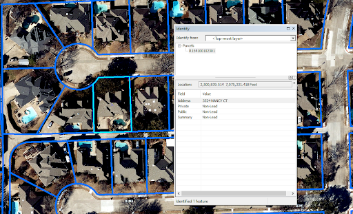
To create its service line inventory, the City of Plano turned to OpenGov’s Cartegraph Asset Management, knowing it could leverage the system’s integration with ArcGIS to help identify and locate the service lines in its purview. The city planned to lay GIS data over asset data, creating layers with vital information to inform its service line inventory work.
“OpenGov’s Cartegraph Asset Management and the ArcGIS integration were crucial in our work to create a lead service line inventory. It lets us track historical records and repairs. It gives us information that allows us to go out and see trouble spots and how they correlate with the rest of our system. It’s a game changer.”
The Public Works Asset Management Team for the City of Plano spearheaded the effort to create the inventory. With assistance from the Technology Solutions/GIS department, line features were added using water meter locations and the closest water main to represent the water service line at each address. The goal was to build an inventory that could be easily visualized and provide accurate locations for the lines and other information for maintenance.
To begin populating the public-side service line material for the inventory, the Asset Management Team drew from historical records and as-built drawings. The desktop analysis was the first step to narrowing the number of service lines where the material type was unknown, so field crews didn’t have to inspect every location.
To populate the material type, three data sources were used:
- Ordinance/Regulation Verification. Adopted laws at both the federal and local levels mandated various changes to service lines. July 1, 1988, was when the City of Plano banned lead pipes.
- As-Built Drawing Verification. Using a map made with data from Esri’s ArcGIS, as-built drawings associated with water main installation, which included notes about the material used in the service lines, helped identify the material of large areas of water service lines. A bulk editing feature in OpenGov’s software allowed multiple records to be updated simultaneously, making for an efficient way to input material data for water service lines.
- Historical Task Verification. Documentation of repair work, replacements, and materials was also linked to specific service lines and added to the inventory. The data was then reviewed to identify the material used for the affected line.
Field verification is required when staff don’t have sufficient data to determine service line material. During field verification, a crew visually inspects each service line at the water meter to see what it’s made of.
Result
Using Esri’s ArcGIS integration with OpenGov’s Cartegraph Asset Management, the team successfully created an inventory of over 81,000 water service lines in the City of Plano water system and pushed the needed data to the software to be used by Public Works personnel.
After reviewing these records, the city determined that over 92 percent of public service lines and 50 percent of private service lines contained no lead. This meant that significantly fewer locations would have to be field verified by crews. Using the inventory and associated data, it developed a public comprehensive dataset for property owners to see the material of the public and private water service lines at their addresses. The city’s goal is to have 100 percent of the service line material identified by October 2024 and hopefully demonstrate all services contain no lead.
Without Esri’s ArcGIS, this project would have been incredibly difficult, if not impossible, to complete. The ability to locate every water service line on a map and lay other data on top of each line’s location was a powerful tool in the City of Plano’s efforts to meet the EPA’s requirements.
What’s Next?
On November 30, 2023, the EPA shared a draft rule calling for 100 percent replacement of all lead pipes in US water systems over 10 years. Called the Lead and Copper Rule Improvements (LCRI), the rule goes past the inventory requirement covered in this case study and creates a deadline for replacing the pipes inventoried under the LCRR. The LCRI is currently open for public comment, after which the EPA will finalize it. See the draft rule at regulations.gov.
ArcGIS and Cartegraph Asset Management will be crucial for this next phase in the lead replacement project, helping to identify the location of these pipes and organize the tremendous work that will be required.
Stay Connected with Esri’s Water Team
ArcGIS is an extensive information system that enables modernization of workflows with easy-to-use applications for the field and office. Strengthen your organization with smart water solutions that will increase efficiency and provide insight for decision-makers. Visit the Esri Water Utilities web site for more information.
Join the Water Utilities Community
Follow #EsriWater on social media: Twitter | LinkedIn
Subscribe to the Water Industry newsletter “Esri News for Water Utilities and Water Resources“
About the author