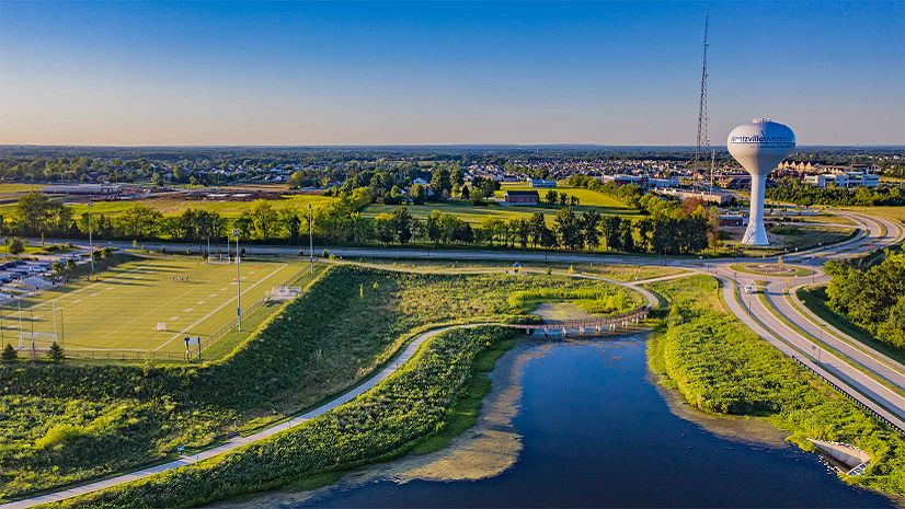
For the City of De Pere, Wisconsin, GIS is a critical business system supporting water, sanitary sewer, and stormwater operations. Serving more than 25,000 residents and managing approximately 380 miles of utility mains and more than 20,000 utility assets, the city relies on accurate infrastructure data to support planning, engineering, maintenance, and daily operations across departments. For more than 20 years, De Pere has invested in building and maintaining a mature GIS program that is widely adopted throughout the organization. As the city looked to modernize its technology platform and position itself for future growth, it embarked on a transition from Esri’s geometric network to ArcGIS Utility Network.
The Challenge
Over two decades, the City of De Pere developed a mature GIS program that became deeply integrated into utility operations and decision-making across the organization. However, as Esri technology evolved, the city recognized that its legacy geometric network could no longer be maintained within ArcGIS Pro. The transition presented an opportunity to modernize utility data management while preserving the workflows and outputs that staff relied upon every day.
Through conversations with an Esri solution engineer and independent research, the city evaluated several paths forward, including removing network connectivity, implementing a trace network, or adopting ArcGIS Utility Network. After assessing the available options and the long-term value of advanced network modeling and analytics, city staff determined that ArcGIS Utility Network offered the strongest foundation for the future. They also recognized that a successful implementation would require specialized expertise and partner support.
At the same time, the GIS Division needed to continue supporting daily operational demands, making it difficult to dedicate resources to such a complex migration effort. The city also sought to strengthen governance practices surrounding both GIS content and enterprise systems. While responsibilities between the GIS Division and IT Department were generally understood, formal documentation was needed to clearly define ownership, administration responsibilities, maintenance schedules, and operational procedures.
Like many utilities, the city needed a framework for managing content naming conventions, metadata standards, tagging practices, user and group administration, development-to-production workflows, and content life cycle management. Establishing these standards was critical for improving trust in GIS data, ensuring consistency across departments, and supporting long-term system sustainability. The city also wanted to position itself for broader user participation through ArcGIS Enterprise Portal and branch versioning workflows, enabling subject matter experts to contribute updates while maintaining appropriate governance controls.
One of the most significant workflow limitations involved utility editing. Editors previously built network features individually, manually creating assets and entering attributes one at a time. The process was time-consuming and lacked automated validation, making it more difficult to identify errors before changes were incorporated into the utility network.
The Solution
The city partnered with Avineon, an Esri partner with extensive experience supporting municipal and utility organizations, to modernize its GIS environment and implement ArcGIS Utility Network. Working closely with De Pere’s GIS, IT, and Public Works teams, Avineon developed and executed a comprehensive modernization strategy that included
- Upgrading ArcGIS Enterprise.
- Deploying Portal for ArcGIS.
- Designing and implementing ArcGIS Utility Network for water, sanitary sewer, and stormwater systems.
- Developing standard operating procedures.
- Supporting governance and development-to-production workflows.
- Organizing and optimizing Portal content and administration.
- Providing user training, cutover assistance, and post-implementation support.
Beyond the technical implementation, Avineon helped the city establish an enterprise content administration framework that defined roles and responsibilities, system architecture, content standards, user management practices, and governance procedures. These documented workflows and workflows within GIS provided greater clarity between GIS and IT responsibilities while creating a scalable foundation for future growth.
The implementation focused on maintaining existing business processes while introducing the advanced capabilities of ArcGIS Utility Network. Staff were trained on new editing, validation, and subnetwork management workflows, helping ensure a smooth transition from legacy geometric network operations.
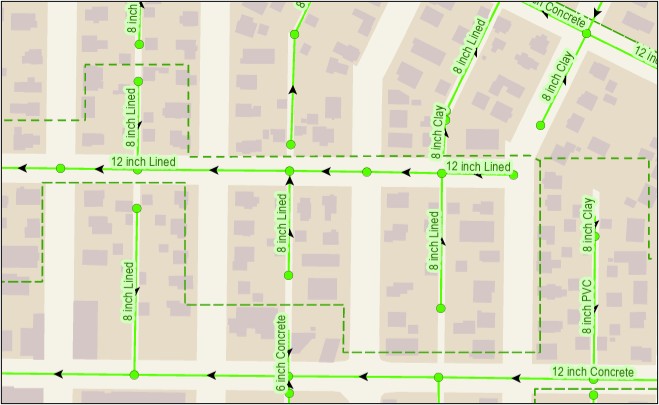
To improve data management efficiency, the city adopted group editing templates and attribute rules. These capabilities automate the creation of related assets and prepopulate commonly used attributes, reducing manual data entry while improving consistency and accuracy.
The Results
The modernization effort enabled the City of De Pere to preserve its highly adopted GIS workflows while establishing a more resilient and scalable utility data management platform. ArcGIS Utility Network now provides the city with improved data integrity, enhanced network modeling capabilities, and a modern enterprise architecture that supports future growth. Utility datasets remain visually familiar to users while benefiting from stronger security, storage, and system administration capabilities.
Daily editing workflows have become faster and more efficient. Group editing templates reduce the number of manual steps required to add new assets, saving an estimated five to ten seconds per asset edit. Attribute rules automatically populate common information, further reducing editing time and improving data consistency.
“Because GIS is widely adopted in our organization, we knew transitioning to the ArcGIS Utility Network was necessary to allow us to provide the best possible utility outputs for city departments, contractors, and utility locators—all of which are needed to successfully provide services to our residents. Avineon’s support allowed us to meet our system modernization goals, keep existing business processes functioning, and improve upon prior operations and practices.” —Kristen Vincent, GIS Manager, City of De Pere
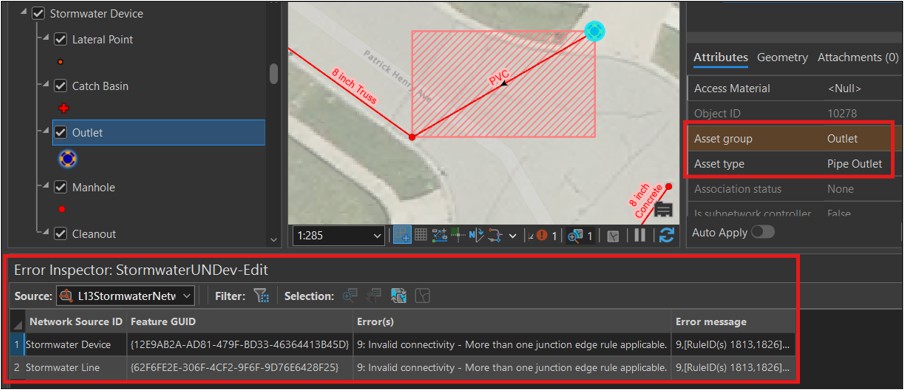
The ArcGIS Utility Network validation framework has also improved data quality and operational confidence. Editors receive immediate feedback when network rules are violated, allowing issues to be corrected before they become part of the production system. For example, the system can automatically identify invalid asset relationships that previously may have gone unnoticed.
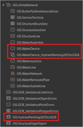
The city has also improved integration between GIS and field operations. Previously, hydrant maintenance data relied on exported snapshots of GIS information. Today, branch versioning and related table workflows support more seamless integration between field inspections and GIS records, helping ensure that operational data remains current and accessible.
“Having current and future records of our distribution system hydrants with inspections in the GIS database should help us better track our maintenance efforts and thereby making us more efficient and targeted with that maintenance. This can also be applied to our valve turning operations and evaluations program.” —Eric Zygarlicke, Water Department Supervisor, City of De Pere
Beyond operational efficiencies, the city is positioning itself to use utility network data in new ways. Development Services staff are exploring how ArcGIS Utility Network modeling can support development review processes by evaluating infrastructure impacts before construction begins. This capability will help the city provide timely feedback to developers and elected officials while ensuring that future growth is supported by well-planned public infrastructure.
“The Development Services Department Planning and Economic Development Divisions support existing businesses and welcome new development into the city. With Avineon’s help in establishing the ArcGIS Utility Network, the city now hopes to model proposed projects against our utility mapping. This will enable us to deliver timely feedback to applicants and elected officials, ensuring that growth is supported by well-planned public infrastructure.” —Dan Lindstrom, Development Services Director, City of De Pere
Overall, the project delivered more than a technology upgrade. It established a modern utility data platform, strengthened governance and administration practices, improved operational efficiency, and positioned the City of De Pere to leverage network modeling and enterprise GIS capabilities well into the future.
Partner Perspective
Avineon’s combination of ArcGIS Utility Network expertise, implementation experience, and ongoing support helped the city modernize its GIS environment while minimizing disruption to existing operations. The partnership allowed city staff to continue delivering critical services while building a foundation for future innovation.
Key Benefits:
- Modernized GIS architecture with ArcGIS Enterprise and Portal for ArcGIS
- Successfully migrated water, sanitary sewer, and stormwater systems to ArcGIS Utility Network
- Improved editing efficiency through group editing templates and attribute rules
- Automated validation to identify errors before they impact operations
- Enhanced integration between GIS and field inspection workflows
- Strengthened governance, security, and data management practices
- Positioned to support future utility modeling and development review initiatives
- Maintained continuity of existing business processes while enabling long-term innovation
Stay Connected with Esri’s Water Team
ArcGIS is an extensive information system that enables modernization of workflows with easy-to-use applications. Strengthen your organization with geospatial solutions that will increase efficiency and provide insight for decision-makers. Visit the Esri Water Utilities web site for more information.
Join the Water Utilities Community
Follow #EsriWater on social media: X | LinkedIn
Download the Building a Modern Network Information Management System eBook
Subscribe to the Water Industry newsletter “Esri News for Water Utilities and Water Resources“