Authored by: Rémi Mayou, GIS Engineer at SIARE
SIARE is a public intermunicipal authority in France responsible for wastewater, stormwater, and river management in the Enghien-les-Bains area. It serves 26 municipalities across both urban and rural territories, providing services such as sanitation, flood prevention, and environmental protection to local authorities, residents, and businesses.
Introduction
Our project focuses on migrating our wastewater network management system from Elyx to 1Water, enabling a transition to a modern, Esri-based GIS platform.
We have been using the Elyx solution for over ten years to manage our wastewater assets. Over time, the system became outdated, leading us to adopt 1Water, a next-generation solution built on modern technologies and fully integrated with the Esri ecosystem.
This transition allows us to leverage advanced GIS capabilities to enhance both asset management and operational workflows. While Elyx met our core asset management needs, 1Water provides more powerful analytical and operational tools. It enables us to better understand network behavior, including flow dynamics, and improves operational monitoring such as tracking defects, maintenance activities, and overall network condition.
The transition to 1Water was not just a technical upgrade, but a transformation in how we manage and operate our wastewater network.
Challenge
Before implementing 1Water, the management of our wastewater network operations workflow was a significant challenge.
While Elyx enabled us to manage and store asset data (such as pipe dimensions, type of water, and infrastructure characteristics), it lacked a structured and efficient way to handle operational data related to network maintenance and activities. As a result, we had to rely on improvised methods to capture operational information.
In practice, all data—both asset-related information and operational records—was stored within a single attribute table. For example, if we needed to record that a section of the network had been cleaned (e.g., pipe flushing) or inspected, we had to add new columns directly into the same table that already contained asset characteristics.
Over time, this approach created several issues:
- The attribute table became increasingly complex and overloaded, with a growing number of columns.
- Data became difficult to manage, read, and maintain.
- It reduced the usability and clarity of the dataset.
- It limited our ability to effectively analyze or visualize the data, particularly in a GIS context.
A simple way to illustrate the problem is to compare it to an Excel spreadsheet where asset attributes and operational records are mixed together in the same table. Instead of having a clear structure, everything was combined, making it hard to extract meaningful insights or perform efficient workflows.
Ultimately, the business problem was the lack of a structured data model and dedicated tools for operational management. This resulted in inefficient workflows, poor data organization, and limited exploitation of the data for decision-making and network management.
This situation highlighted the need for a solution that could
- Clearly separate asset data from operational data.
- Provide a more structured and scalable data model.
- Enable efficient tracking and analysis of maintenance activities.
- Improve data usability within a GIS environment.
Solution
SIARE implemented 1Water, a modern GIS solution built on the Esri platform (ArcGIS Pro, Portal for ArcGIS, and ArcGIS APIs) to transform how its wastewater network is managed on a daily basis.
The key improvement lies in streamlining operational workflows. Previously, field teams had to report their activities to a GIS specialist, who manually entered the data. With 1Water, field crews now directly capture and update information themselves, improving efficiency, data accuracy, and timeliness while freeing up GIS resources for higher-value tasks.
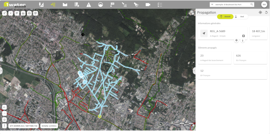
The solution also enhances network understanding and analysis. Using advanced tools like flow propagation, users can instantly visualize how water moves through the network, both upstream and downstream from any given point. What once required years of field experience can now be achieved in seconds.
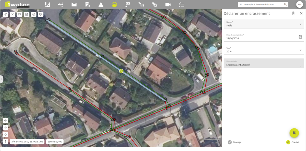
Operational activities are now structured and easy to manage, with maintenance data (e.g., cleaning operations, condition assessments) recorded in dedicated tables and directly linked to network assets.
In addition, 1Water centralizes CCTV inspection data, allowing teams to import robot inspection reports (including photos and videos) and visualize them directly within the GIS, replacing previously fragmented files and reports.
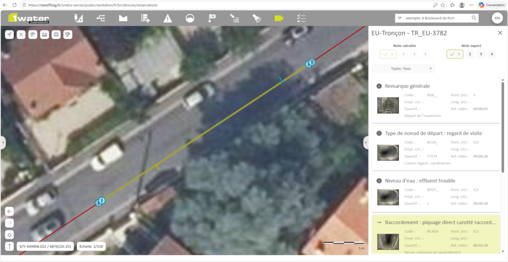
CCTV inspection reports, photos, and videos are accessed directly within 1Water, providing a complete view of asset conditions in a single GIS environment.
Finally, the platform enables the creation of clear dashboards and visualizations, supporting better communication and decision-making across teams and with stakeholders.
Overall, 1Water provides SIARE with a fully integrated, user-friendly, and data-driven environment, transforming both daily operations and long-term network management.
“The real strength lies in having better-structured, more usable data thanks to this migration, along with efficient Esri tools.” —Rémi Mayou, GIS Engineer at SIARE
Results
Although we did not establish quantitative performance indicators prior to migration, making direct numerical comparisons difficult, the benefits of implementing 1Water are clear and significant, particularly in terms of workflow efficiency, data usability, and operational practices.
First, while our asset data management was already well-maintained in Elyx, the most impactful improvements concern the operation and maintenance of the wastewater network. Previously, operational data was stored in an unstructured way within a single table, making it difficult to use and analyze. With 1Water, operational data is now managed in dedicated, well-structured tables, significantly improving data clarity, accessibility, and usability.
This structured approach enables
- Easier data analysis and reporting.
- More effective use of GIS capabilities.
- Better tracking of maintenance activities such as cleaning and inspections.
Another key benefit is improved tool usability and accessibility. 1Water provides a more intuitive interface compared to the previous solution, which makes it easier for users to adopt and integrate into their daily workflows.
This has led to a major shift in how work is performed. The system is no longer used exclusively by the GIS specialist but can now be directly accessed by operations staff in the field. Field agents are able to input and update data themselves, improving both the timeliness and accuracy of information.
This evolution has also generated indirect efficiency gains. By enabling data to be captured directly during field operations, we reduce the need for redundant site visits. In practice, this means
- Avoiding situations where a second agent must revisit the same location.
- Reducing duplicated effort.
- Optimizing resource allocation.
Overall, the main benefits of the project are reflected in improved workflows and working methods, rather than strictly measurable cost savings. The migration to 1Water has allowed us to
- Modernize our tools and processes.
- Improve collaboration between teams.
- Enhance the quality and usability of our operational data.
- Lay the foundation for more advanced data-driven decision-making.
“Without a tool like this, it takes years of field experience to develop an intuitive understanding of the network. With 1Water, those years of experience disappear in a single click. It’s truly transformative.” —Rémi Mayou, GIS Engineer at SIARE
Project Team
The success of this project relied on close collaboration between our internal team and 1Spatial by VertiGIS’s experts.
On the client side (SIARE), a single resource primarily carried out the project: the GIS specialist, who was fully responsible for managing the migration internally. This included participating in workshops, refining the data model mapping, and ensuring successful implementation and adoption of the new system.
This project highlights a lean but highly collaborative team structure, combining targeted external expertise from 1Spatial by VertiGIS with strong internal ownership to successfully deliver the solution.
Partner Involvement
1Spatial by VertiGIS helps organizations unlock the full value of their geospatial data. Through software, services, and industry solutions, 1Spatial by VertiGIS enables better decision-making across sectors like telecom, utilities, transportation, and government. Their work supports safer, smarter, and more sustainable infrastructure around the world.
Roles supporting the project included:
- A primary project lead was responsible for overseeing and coordinating the migration as a whole, ensuring progress and alignment throughout the project.
- A data model specialist (ArcGIS Utility Network) played a key role in supporting the transition between Elyx and 1Water. She led workshops dedicated to mapping and aligning the two data models, which were a critical component of the project.
- Additional contributors were involved on a case-by-case basis, particularly for delivering training sessions on the Esri and 1Water tools, including ArcGIS Pro, Portal for ArcGIS, 1Water Web, and 1Water Desktop.