For more than 170 years, Pennichuck Water Works has provided high-quality water to communities across southern and central New Hampshire. In recent years, the utility has taken a thoughtful, phased approach to modernization thanks to dedicated, integrated internal teams. They upgraded their geographic information system (GIS), transitioned to ArcGIS Utility Network, and deployed map-based field workflows that seamlessly connect asset management and operations. Building on these foundations, Pennichuck is expanding its digital transformation into facilities, using digital twins to create a more complete and connected view of its systems.

Modernizing Asset Management in Facilities
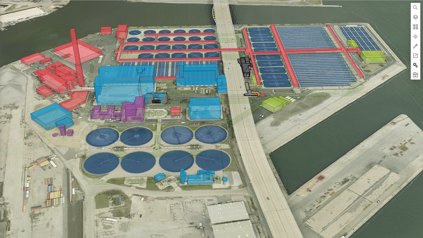
Pennichuck had already made significant strides in modernizing its distribution network model. This included upgrading their enterprise GIS, converting to ArcGIS Utility Network, upgrading to a GIS-centric work and asset management platform, and creating map-first workflows for work orders and inspections. Although these areas of the operation had been strengthened, facilities such as pump stations and treatment plants lagged behind. Represented mostly as points on a map, these facilities were still reliant on operator expertise and supported by limited, system-level tools.
Unlike pipelines and valves in the distribution system, Pennichuck’s facilities did not start from the same level of detail within GIS and asset management systems. In addition, they contain layers of complexity within a single location with multiple assets working together inside a single “container.”
Existing systems offered limited visibility into this environment, due to their lack of development and reliance on effective but manual operational processes. In particular, the utility network lacked detailed representations of station-level assets, making it difficult to visualize how equipment fit together or to connect daily tasks such as inspections and work orders to the bigger operational picture.
This represented a gap when compared to the overall strategy, and Pennichuck knew it. Now, they were ready to tackle it as an opportunity to improve operations and reduce risk by integrating facilities into the GIS environment. Doing so would provide staff with a unified view of all assets and enable them to work with the same clarity in the field and inside a plant. They saw the opportunity to build a strong foundation while simultaneously evaluating and improving their asset management program for facilities and vertical assets.
Partnering for Success
Bringing this vision to life required the right expertise, and Pennichuck turned to LandTech, an Esri partner with deep experience in reality capture, 3D modeling, and GIS-based digital twin development. With a background supporting water utilities across New England and beyond, LandTech brought both the technical skills and industry insight needed to succeed.
From the start, the partnership was a true collaboration. Pennichuck’s teams worked side by side with LandTech, testing and refining models and applications together. This hands-on, iterative approach ensured the final solution not only mirrored real-world workflows but also felt intuitive for staff, setting the stage for smooth adoption and lasting impact.
Exploring Capabilities
Pennichuck launched a pilot project to explore the role of digital twins in facilities management. The effort focused on three key sites: a pump station, a booster station, and the finish water pumping station at the main treatment plant. The workflow followed a structured but adaptable path:

Phase 1 – Scan
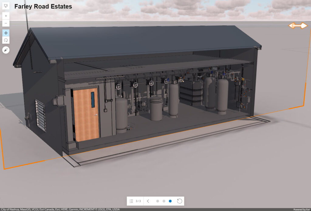
Using a Leica RTC360 laser scanner, LandTech captured each site at 2mm accuracy, with the added benefit of 360-degree imagery. The scanner’s speed, just one to two minutes per scan, enabled the team to complete the main treatment plant in a week, while both smaller stations were scanned in less than a day.
Phase 2 – Model
The scan data was converted into highly accurate 3D models. Water process devices were modeled at Level of Development (LOD) 350, providing detail sufficient for precise identification and operational context. Structural elements were modeled at LOD 200, balancing accuracy with efficiency.
Phase 3 – GIS Conversion
The models were transformed into GIS-ready formats, including building scene layer packages, web scene layers, and derivative 3D point features. A critical step in this phase was Pennichuck staff participation in asset identification within the models, a painstaking but essential process that enabled interactivity and ensured the GIS environment reflected real-world conditions.
Phase 4 – App Configuration
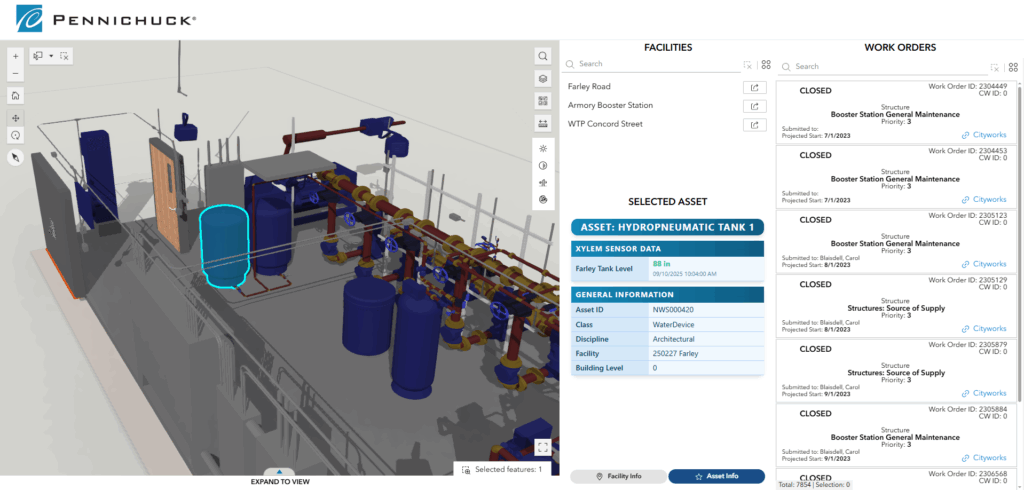
The interactive models were deployed through a browser-based application built with ArcGIS Experience Builder. Customization leveraged ArcGIS Arcade expressions and Python scripts to create a seamless experience. Staff could explore facilities in 3D, visualize inspections and work orders directly in the scene, and launch into existing systems with a single click—including linking to mobile applications for work order management.
Phase 5 – System Integration
Data integration was designed to maximize visibility and ease of use while minimizing complexity. Asset management data was connected via web services, operational data was integrated through APIs, and deep links enabled smooth navigation between applications. Python routines supported real-time and historical data polling, writing results into hosted tables for use within the app.
Staff Reaction
The response from staff was immediate. Seeing familiar facilities in realistic 3D detail was exciting, but what truly resonated was the usability. Staff valued being able to see multiple systems together in one spatial view, without needing to toggle between platforms.
For operators, the workflow felt familiar: Visualize a work order in context, then click directly into the work order system. This mirrored the field workflows already established for distribution assets, making adoption natural and seamless.
“By integrating the 3D models with our CMMS, an operator can stand in front of any asset in any station and instantaneously pull up maintenance history on that exact pump. No searching. No phone calls. I’m excited to continue integrating the digital twins into our evolving asset management program.”
—Erin Holmes, P.E. Director of Engineering and Environmental Services, Pennichuck Water Works
As for the GIS staff, including manager Jay Guarneri, they couldn’t be happier to have detailed, realistic visualizations of facility assets, which make digitization and the accurate updating of existing utility network data easier than ever.
Providing a Unifying Framework
The pilot has strengthened Pennichuck’s confidence in the value of digital twins as a foundation for future growth. Staff are beginning to discover new opportunities for improvement and innovation, while leadership is already exploring how the approach can be scaled to additional facilities across the system.
The project also reinforces GIS as a core enterprise system at Pennichuck, serving not just as a mapping tool, but as a unifying framework that connects people, data, and operations. Although still early, the solution has already delivered what Pennichuck was seeking: the “missing piece” of their modernization journey and a platform for ongoing innovation.
“This digital twin represents a huge leap forward for data visibility for our facilities. I expect it to be transformative for our facilities operators and managers.” — Jay Guarneri, GISP, Senior GIS Administrator, Pennichuck Water Works

Stay Connected with Esri’s Water Team
ArcGIS is an extensive information system that enables modernization of workflows with easy-to-use applications. Strengthen your organization with geospatial solutions that will increase efficiency and provide insight for decision-makers. Visit the Esri Water Utilities web site for more information.
Learn more about leveraging ArcGIS to streamline vertical asset management
Follow #EsriWater on social media: X | LinkedIn
Subscribe to the Water Industry newsletter “Esri News for Water Utilities and Water Resources“