It is time to turn the page to 2026, but before we do, here is a quick review of Public Works GIS for 2025.
This year we completed the first in-person Esri Public Works GIS Seminars, visiting six cities across the U.S. and meeting with almost 500 public works professionals. The theme was Next Generation Public Works is Powered by ArcGIS. Be on the lookout for more of these seminars in 2026.
Key Takeaways from 2025
- ArcGIS is a mission-critical, enterprise IT business system that is scalable and supports the entire spectrum of Public Works.
- ArcGIS is a gateway to integrate advanced technologies into your business.
- The most sustainable way to expand your GIS is with ArcGIS Solutions.
ArcGIS Solutions is a collection of industry-specific configurations of ArcGIS that align with your business needs, transform your use of ArcGIS, and help you maximize the investment you are making in location-based data and technology.
The ArcGIS Solutions team’s mission is to build high-value solutions that reduce the time it takes you to deploy geo-enabled solutions in your organization. This is the fastest and most sustainable way to expand support for public works operations with GIS.
Of the 148 currently available solutions, 56 support public works.
Top Ten Public Works ArcGIS Solutions Deployed in 2025
- Water Utility Network Foundation
- Citizen Problem Reporter
- Sewer Utility Network Foundation
- Tree Management
- Water Distribution Data Management
- Road Closures
- Sign Management
- Capital Project Coordination
- Roadway Management
- Stormwater Data Management
Over 6,000 deployments of these top ten solutions were deployed in 2025, and almost 11,000 total deployments of public works solutions occurred in over 4,300 organizations.
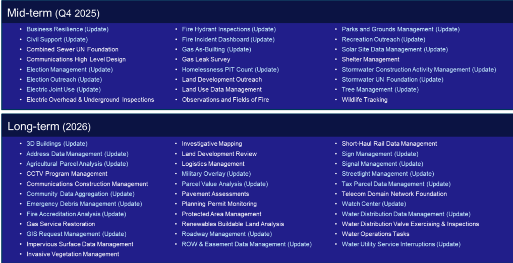
Looking Ahead to 2026
There will be 16 new solutions and 18 solution updates. Here are the Top Five Public Works ArcGIS Solutions coming in 2026:
- CCTV Program Management
- Impervious Surface Data Management
- Pavement Assessments
- Water Distribution Valve Exercising & Inspections
- Water Operations Tasks
For more detailed information on the future of ArcGIS Solutions, check out the current roadmap:
Events and Engagement
We attended many events in 2025, including:
- APWA AI Summit
- Esri Partner Conference
- North Carolina GIS Conference
- APWA North Carolina Leadership and Management Conference
- Esri International User Conference
- APWA Public Works Expo (PWX)
- NRPA Conference
- GPN GIS Pro Conference
- Trimble Innovate Conference
- Salem & Marion County, Oregon GIS Day
Look for us at various events in 2026, including Esri International User Conference, PWX, NRPA, and GIS Pro.
Industry Leadership
I served on the APWA Technology Committee, APWA North Carolina Connect Committee, and the GPN Board of Directors and Conference Committee. I was chosen to join the APWA Foundation Board of Trustees and look forward to working with this important group, and continuing my roles on the other groups mentioned above.
We authored a lot of content like blogs and articles on Esri channels, as well as APWA Reporter magazine, Parks & Recreation magazine, and GovLoop. We will continue to deliver thoughtful and valuable content next year in a variety of forms and channels to show that Next Generation Public Works is Powered by ArcGIS.
Thank You
Thanks to all the dedicated public works professionals out there providing and maintaining the infrastructure and services that are essential to our welfare and quality of life, and those who participated in the events, read our content, and deployed GIS-based public works solutions.
We look forward to 2026 and our further support for the public works community. Happy Holidays to all!
Stay in Touch
Subscribe to our monthly eBrief to keep up with all things Public Works & Engineering GIS.