Northumbrian Water Group is leading a transformative effort to unite the UK water sector through open data. By championing transparency and collaboration, they are creating a shared digital ecosystem that enables utilities to tackle common challenges, such as aging infrastructure, climate resilience, and population pressures, more effectively. This initiative fosters innovation, accelerates problem-solving, and empowers stakeholders to make data-driven decisions that safeguard water services for future generations.
Challenge
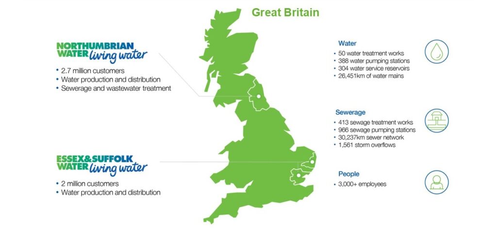
For Northumbrian Water Group (NWG), which serves 4.7 million customers across northern and southeastern England, challenges are both operational and societal. “We’re seeing some of the hottest temperatures in the summer and some of the wettest winters on record,” explained Martin Jackson, chief information officer at NWG. “Our infrastructure was never really designed to cope with these extremes, which is putting pressure on our infrastructure and is leading to a lot more visibility of our sector in the UK at the moment.”
At the same time, the rising cost of living is heightening public scrutiny of utility spending. “It’s becoming increasingly challenging for our customers to be able to pay their household bills,” Jackson said. “If you marry that up with the investment that’s required in infrastructure, it becomes an interesting time where we’ve got to work extremely hard to maintain trust with our customers.”
Like other water companies in the UK, NWG recognized that it needed to rethink how it managed and communicated information about its networks.
Solution
In 2020, NWG and several partner utilities began exploring how they could collaborate more effectively through data sharing. “A few water companies got together and thought: Actually, is it better for us to do open data collectively as a sector?” recalled Andrew Myers, lead architect at NWG. “Will we get more value from it? Will it be more efficient to work together?”
The result was Stream, an independent, sector-wide initiative designed to unlock the potential of water data for the benefit of customers, society, and the environment. Backed by innovation funding and working with civil society partners, Stream brought together nearly all UK water and wastewater companies to share data in standardized, interoperable formats.
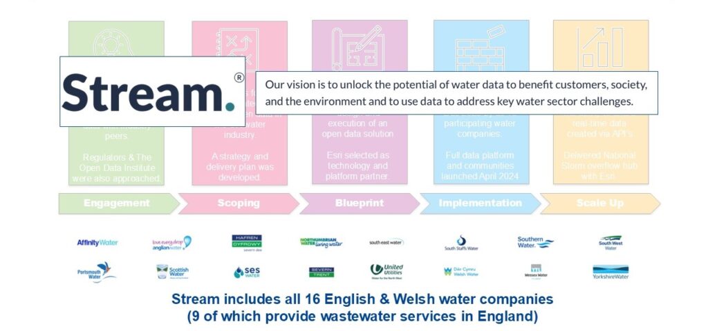
When the time came to choose a platform, the project team didn’t begin with technology requirements—it began with goals. “We didn’t necessarily say it must be a geospatial platform,” Myers said. Rather, the team knew it needed something that could provide decentralized data cataloging, support community features, and help tell stories with data. “Esri’s platform turned out to be the perfect fit,” said Myers.
The Esri geospatial platform provided several essential capabilities:
- Decentralized data cataloging across multiple organizations, allowing each utility to publish its own datasets while contributing to a shared national framework
- Geospatial visualization for understanding complex infrastructure networks and their environmental contexts
- Interactive storytelling tools that make technical information understandable to the public
- Open API access so that developers, researchers, and regulators can build applications and perform analyses using the same authoritative data
Transparency in Action
By the end of 2023, Stream was publishing its first datasets. A high-impact use case soon emerged in response to the requirement that English water companies provide real-time maps of their combined storm overflows (CSOs), which serve as pressure release points in sewer networks during heavy rainfall. Initially, each wastewater company developed its own digital map—often built on geographic information system (GIS) technology, but with inconsistent interfaces and standards. Stream and its partners saw an opportunity to unify these efforts, challenging themselves to explore whether all 14,000 CSOs across England could be combined into one single view.
The result was the National Storm Overflow Hub, an online application built on Esri technology. The hub consolidates near real-time data from nine wastewater companies in England, updating within 60 minutes of any CSO activation. Each CSO is represented by a point on the map: purple for active overflows, gray for inactive.
Clicking on any site reveals its owner, the time of activation, and any associated improvement activities, providing immediate, location-based insight into system performance. “It’s a big check for transparency,” said Jackson. “That data comes together, it’s accessible, and it’s available for anyone to explore.”

Results
The response was immediate. Within the first week of launch, more than 5,000 people accessed the data through the online tool. Researchers and developers began using the API to combine the CSO data with other national datasets, modeling river health and water quality across the UK.
As Myers noted, the value of Esri’s platform extends beyond visualization. “The majority of our data has a geospatial component,” he said. “Being able to share that visually helps with engagement—for customers to see what’s happening near them, and for researchers to access national-scale data that they can download or connect to via APIs.”
Ultimately, Stream is driving a cultural shift toward openness and shared innovation. “There’s a real sense of excitement across the sector,” Jackson reflected, “but a real feeling that we’re only just getting started.”
The Stream project continues to evolve from a pilot initiative into a sustainable platform with active backlog management and a growing ecosystem of partners. It is demonstrating how open data, supported by Esri’s geospatial platform, can transform utility management at both the organizational and sector levels.
With ongoing platform enhancements, a growing ecosystem of collaborators, and national-scale data access, the Stream project offers a blueprint of how utilities can harness open data to deliver smarter, more sustainable, and more transparent water services.
Learn More
England’s Northumbrian Water is leading the way in using real‑time mapping and AI‑driven simulations to better understand and manage storm overflows. To learn more, watch the Esri Blog video featuring CIO Nigel Watson and his presentation from Esri’s 2025 Senior Executive Summit.