The housing shortage in America is a genuine crisis. The lack of sufficient supply over the last several years has had a direct impact on affordable housing, making home ownership, one of the most common ways for lower and middle-income households to build wealth, all but unattainable for millions of Americans.
A long-awaited grant program from the U.S. Department of Housing and Urban Development (HUD) was released recently. Initially created as the YIMBY Incentive Grant Program, it has changed names to Pathways to Removing Obstacles to Housing, or PRO Housing for short. The name may have changed but the goals and parameters of the program are the same. PRO Housing is designed to support communities who are taking effective steps to remove barriers to affordable housing. These steps can include reforming a legacy zoning ordinance and corresponding land use policies and regulations, streamlining the workflows involved in approving housing, ensure access to neighborhood amenities, and preserving and rehabilitating existing housing stock.
Some quick facts about the program:
- Total appropriation for the program is $85 million
- HUD anticipates approximately 20 winners, though that is likely to vary a great deal based on need.
- The minimum award will be $1 million, and the maximum will be $10 million.
- Eligible applicants are local and state governments, MPOs, and multijurisdictional agencies.
- Applicants submit their request through Grants.gov. The deadline is 11:59 pm on October 30.
Opportunities for Planners
It likely does not take long for most planners reading this to understand the impact this program can have on their community zoning and housing initiatives. Cities and counties with dated zoning ordinances are likely not meeting the modern housing needs of their residents, particularly as household size continues to shrink. Many older ordinances accommodate single-family homes and apartments, with few options in between…if any at all. In these cases, mixed use developments are likely not options, either. The cost of significant updates and changes to a zoning ordinance and comprehensive plan is likely to go well into six figures.
Even if the existing zoning ordinance accommodates denser units (e.g., townhomes, duplexes, cottage courts, etc.) and mixed-use developments, the PRO Housing program can help state and local governments establish implementation of equitable and resilient approaches to the production and preservation of affordable housing. The PRO Housing program can provide funding to rectify this problem to sustainably meet the needs of community residents.
It Starts with a Geographic Approach
As with nearly all things planning and housing related, location is going to be a key consideration. Planners must leverage a geographic approach to housing policy, whether that entails specific or wholesale changes to the zoning ordinance, streamlining the regulation and permitting process, or identifying housing for rehabilitation and preservation. GIS provides the tools that empower planners to make data-driven housing policy decisions.
The first step is understanding where housing needs are the greatest. Where is the available affordable housing in the community? Where is it most lacking/needed? Is it accessible to households that are most in need?
The second step is to garner business intelligence from the permitting system to have a broader look at the patterns and trends of housing development over time. What types of units have we approved over the last 5, 10, or 15 years? Are those the same types of units that are in demand today, or are people pursuing those because they have no other option?
The third step is to take a data-driven approach to policy making. Now that we understand the needs and development patterns, what changes do we need to make to our policy? Is it as simple as updating a portion of the zoning ordinance to accommodate denser development? How would a walkable and/or mixed-use development with market-priced and affordable housing be received in certain neighborhoods? Where are the greatest housing needs? Do we have the economic and social infrastructure to support these new types of developments?
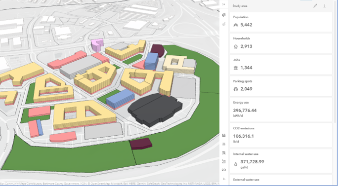
With a data-driven policy in place, the fourth step is to generate development scenarios based on these new parameters. Scenario planning will help planners, community leaders, and administrators visualize and analyze these changes. What will our proposed developments look like in relation to existing surrounding developments? How many new households can we add? How many new commercial or office jobs will the mixed-use developments add? What will be the impact on utilities, traffic, and tax revenue?

The final step is civic inclusion. Successfully planned communities don’t happen in a vacuum. They require informing the public and providing multiple ways for them to be able to react and provide feedback. That feedback can come from online surveys, attending a public hearing, freeform comments on a dedicated page, or even drawing on a web map. The key is to commit to making sure that everyone that wants to have a voice in their community’s housing policy has one.
Elevate Your Application
GIS is an integral component to any successful zoning ordinance change or housing policy update. So, whether it’s with or without outside funding, make sure that when you budget for these initiatives, you’re including the software and services needed to ensure a successful project. In the next few days, Esri will be releasing recommended guidelines for communities to leverage GIS in their zoning and housing initiatives. You can also work directly with your Esri account team for this purpose.
A geographic approach to zoning reform and housing policy is essential to meet the modern needs of residents and create a sustainable and thriving community.


