July 30, 2024 |
Dr. Dawn Wright | Conservation
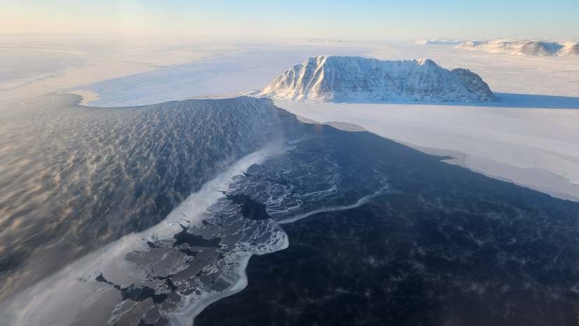
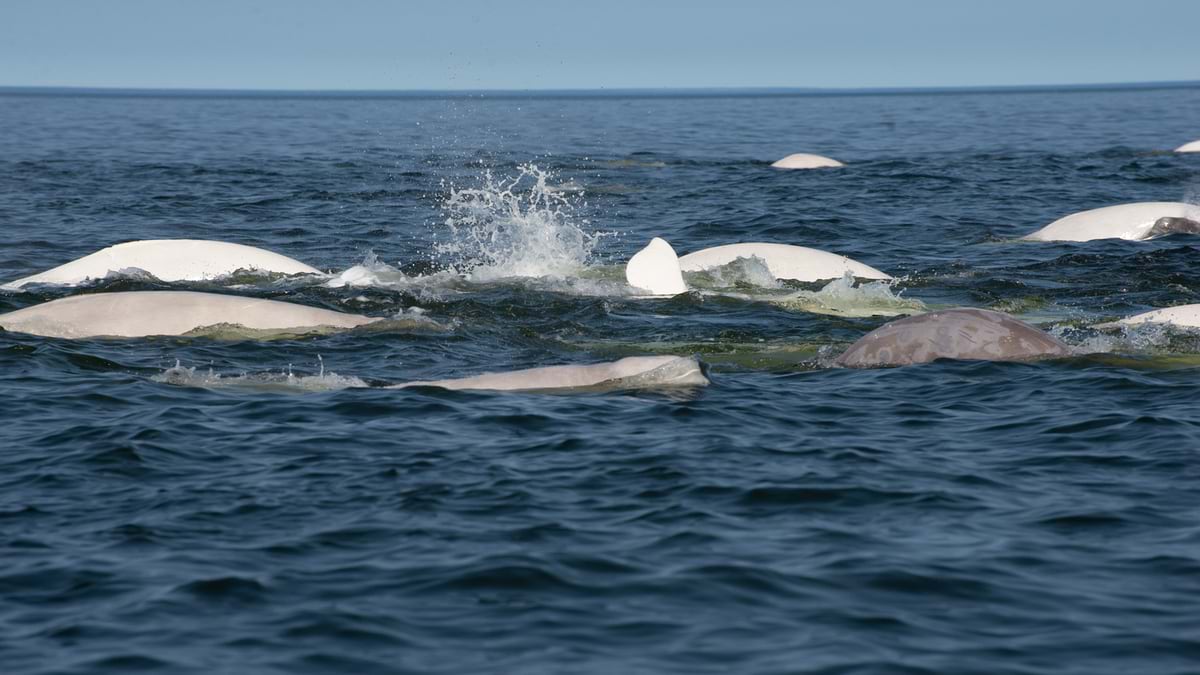
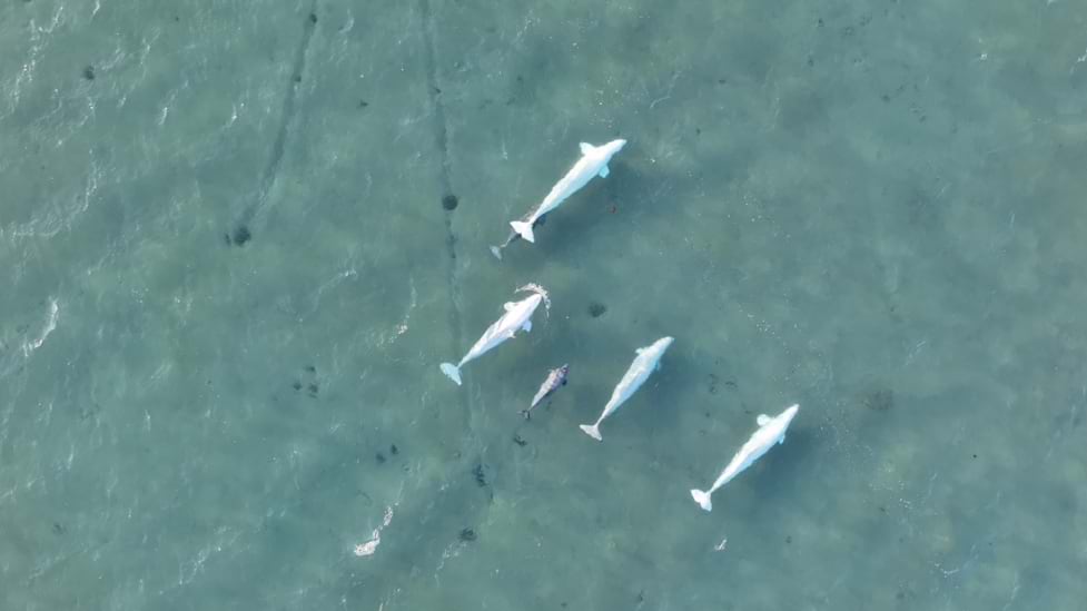
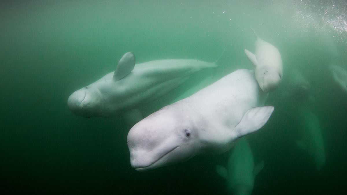
Counting beluga whales begins with a journey to the top of the world. These distinctive white mammals navigate the vast Arctic seas but tracking their population has always been a conservation challenge.
Until recently, the task was both tedious and imprecise. Now, geospatial AI, a powerful combination of artificial intelligence (AI) and geographic information system (GIS) technology, is transforming how scientists count these elusive creatures.
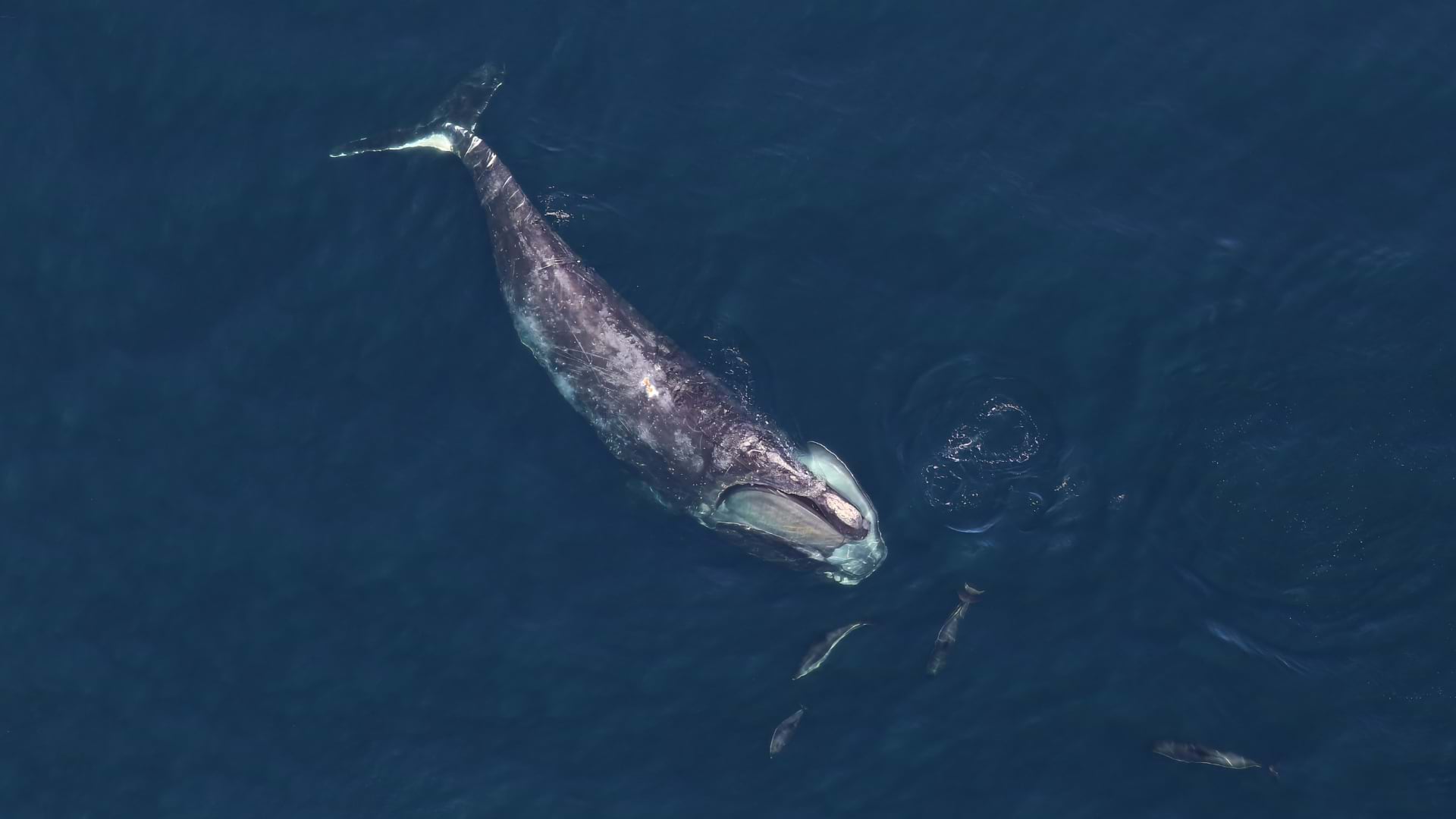
The challenge? Belugas can disappear underwater for long stretches. They can dive over 2,300 feet while hunting cod or other prey. When they do surface, their white coloring can be easily confused with floating chunks of sea ice against the dark blue ocean.
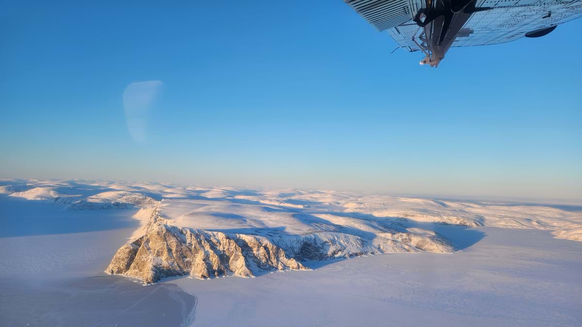
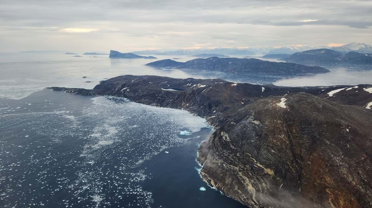
Bryanna Sherbo, a biologist at Fisheries and Oceans Canada (DFO), has spent countless hours aboard small airplanes scouring Arctic waters for belugas. These aerial surveys typically take place when the region’s icy grip loosens and sea ice cover is light, allowing the sociable whales to gather in groups.
Sherbo and her colleagues are documenting the beluga population as the whales become more threatened and endangered in some regions. Aerial surveys inform decisions about stewardship and conservation.
The work blends rigorous science with the art of observation. During aerial surveys, GPS-enabled cameras are mounted inside the aircraft, pointing straight down at the water and snapping photos every few seconds.
Each survey generates thousands of images. Manually identifying whales in each photo can be time-consuming, but outsourcing the analysis to consulting firms is costly.
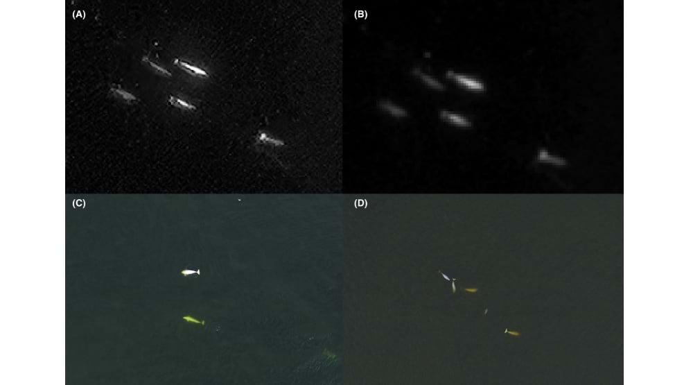
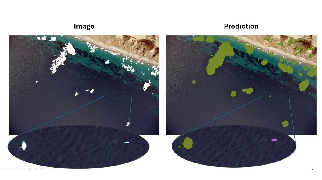
DFO scientists collaborated with Mohamed Ahmed, a solution engineer from Esri Canada, to overcome these challenges. They built a deep learning model that automatically detects beluga whales in imagery. The model, powered by geospatial AI, can analyze thousands of images in hours, and identify whales at an astonishing 88 percent rate of accuracy.
“The auto-detection model is really promising,” Sherbo said. “It has the potential to save lots of time and be more accurate.”
Safeguarding Canada’s Oceans, Wildlife, and Arctic Culture
DFO scientists regularly assess marine mammal populations across Canada. These surveys provide crucial data that helps protect Canada’s ocean wildlife and resources.
As key predators in Arctic waters, beluga whales are an indicator species and serve as early warning signs of ecosystem changes.
Today’s belugas face multiple threats—from pollution and increased shipping to industrial development and ocean warming. Warming temperatures in the polar regions are particularly concerning as they reduce sea ice, creating unpredictable conditions that can trap whales underwater, preventing them from surfacing to breathe.
For generations, many Arctic Indigenous communities have maintained deep cultural connections with these distinctive white whales, relying on traditional knowledge to understand their movements and behaviors.
“The Inuit rely on marine mammals for sustenance,” Sherbo said. Beluga meat and muktuk (whale skin and blubber) are all consumed after an animal has been hunted, offering a nutrient-rich, culturally preferred food source. Despite living in landscapes largely devoid of vegetation, Inuit communities have long prevented scurvy, a disease caused by a lack of vitamin C, thanks to the high vitamin C content in muktuk.
Whale hunts have supported families across the Arctic for thousands of years. Harvesting and sharing qilalugaq (beluga whale) are deeply rooted customs in Inuit communities. These practices symbolize unity and impart traditional wisdom.
The Inuit view qilalugaq as spiritual companions, life sustainers, and cultural teachers, inspiring traditional knowledge about marine ecosystems and survival techniques. Beluga whales are often referred to as canaries of the ocean for their broad vocal range and their “canaries in the coal mine” role in indicating ecosystem health.
Beluga populations were severely depleted in the mid-19th and early 20th centuries due to excessive, unregulated commercial hunting. In the 1980s, DFO established management plans to aid in population recovery. These plans—which are reevaluated and renewed every three to five years—include hunting quotas, seasonal and area closures, and prohibitions on killing calves or adults accompanied by calves.
By monitoring beluga populations, DFO works to protect both the Arctic ecosystem and the cultural traditions of Inuit peoples who depend on these whales.
Before Sherbo and her DFO colleagues conduct aerial surveys, they connect with local Arctic communities to learn where to focus their surveys. These conversations reveal valuable insights about where belugas gather, how they behave, and which areas matter most to local hunters–all helping the team plan more effective flight paths.
“We worked very closely with the Hunters & Trappers Organizations in Nunavut,” Sherbo said. “Community members also joined us as observers on the planes.”
It’s important to Sherbo that local communities be involved in population surveys because the collected data can help to inform hunting quotas. If a species is listed as threatened, or numbers are determined to be low in a certain area or if there is an abundance of animals, this information can be shared with co-management partners to adjust management plans.
To provide the data needed to train the beluga whale detection model, Sherbo and her team conducted the High Arctic Cetacean Survey. In summer 2023, they spent three weeks gathering images across eastern Nunavut, Canada’s largest and northernmost territory. Their efforts—along with supporting drone and satellite imagery—resulted in approximately 60,000 images.
Sherbo analyzed five percent of all images (about 3,000) manually—a process that took nearly a week. She knows what to look for amid the vast expanses of churning ocean and floating chunks of ice. Roughly the size of a large car, solid-white beluga whales lack a dorsal fin—an adaptation that allows them to navigate sea ice more easily.
Sherbo’s expert analysis and labeling of the images was used to train the new deep learning detection model.
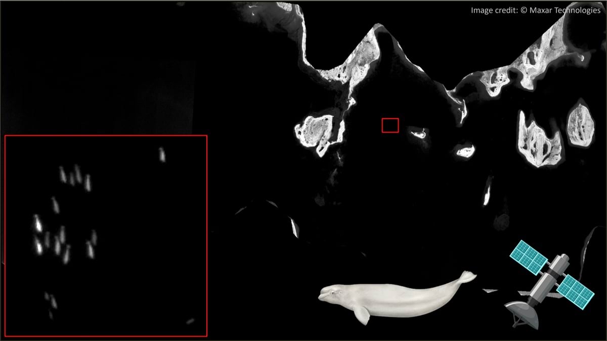
“Within the 3,000 images I read, only 21 photos had marine mammals,” Sherbo said.
The new model proved to be adept at distinguishing the white whales from sea ice and whitecaps that were similar in color, shape, and size.
“Even if the deep learning algorithm isn’t great at classifying which species of whale has been photographed, just eliminating photos of open ocean water is extremely helpful,” she said.
Sherbo and her colleagues had previously tried other methods of analysis of aerial survey, drone, and satellite images that would bypass the tedium of manual image labeling.
They tried crowd counting with paid online image reviewers for reviewing satellite images. One recent efforthad an accuracy rate of between 65 and 70 percent. “What we found is people really want to find whales,” Sherbo said. “There were a lot of false positives . . . if you took that data and used it, you’d overestimate populations.”
They also tried outsourcing AI detection by sending imagery to an external company for automated analysis. “We’ve hired companies to use their proprietary algorithm on images, but they charge per image,” said Sherbo. “It ends up being costly.”
Now, the new deep learning detection model created by DFO and Esri Canada, along with many other deep learning models, will be openly available to other GIS users in Esri’s ArcGIS Living Atlas of the World.
In addition to the speed of analysis offered by the model, Sherbo and her team are excited by the model’s ability to analyze imagery from aerial capture, drones, and satellites.
Each type of imagery has its own advantages and limitations. Researchers typically use a mix of methods depending on their observation needs, the size of the area they want to monitor, and weather conditions.
Sherbo, who has a drone operator’s license, finds the higher resolution and video capabilities of drones extremely useful for studying fine-scale whale movements and behaviors.
Drone footage also allows her to assess the whales’ health. By measuring a beluga’s length to width ratio, the team can evaluate the animal’s overall body condition. This noninvasive method offers a low-stress, efficient way to gather critical species data.
“But, with drones, you have about a half hour per battery,” Sherbo said. “And you can only fly within line of sight without extra permits.” Due to these constraints, drones are primarily used for small-scale surveys over specific areas of interest.
High-resolution satellite images can cover vast swaths of the ocean, providing a fully remote method that avoids the risks and resources demanded by piloted aircraft surveys. Satellites are also immune to cold and can gather images in the less cloudy winter months. Research on beluga whale abundance in CumberlandSound helped establish the use of high-resolution satellites to monitor whale populations and estuary use.
“It’s relatively novel to use satellite imagery for monitoring marine mammals,” said Sherbo. When she and her team started to use satellite imagery, they ground-validated it with aerial imagery taken from drone or aircraft in the same time frame.
“Conducting a plane survey is really time-consuming and requires a lot of resources and personnel,” Sherbo said. “With increasing resolution and availability of satellite imagery, maybe one day we won’t need to fly surveys.”
Frequent satellite-powered surveys would provide DFO researchers a safer, non-invasive method to support their work.
By automating the analysis of massive imagery datasets, the GIS deep learning model enables Sherbo and her colleagues to spend more time understanding Arctic marine mammals and less time trying to find them.
Learn how GIS provides a new window into the undersea world. You can listen to a discussion about this work on Esri Canada’s Geographical Thinking podcast.