
September 15, 2020 |
Jim Baumann | Mapping
Billions of people move through the landscape every day. For more than a century, geographers have searched for order in this apparent chaos. Now, empirical evidence built on cell phone data adds up to a humanity-scale travelogue.
Through our phones, we leave behind a daily breadcrumb trail. Every call or text generates an anonymized, time-stamped record. Based on information in these records, such as signal trajectory and which cell towers were pinged, a person’s general location is constructed after the fact. Even when not in use, our phones send location signals.
While critics have highlighted the exploitive ways phone data is used for commercial gain, researchers investigate anonymized location data for a richer understanding of human behavior that relates to important issues like culture, public health, social equity and urbanization. These studies require a way to contextualize and visualize human activity as it unfolds. Geographic information system (GIS) technology satisfies both objectives, which is why GIS is now the interdisciplinary glue joining several modes of inquiry.
At the beginning of the 21st century, the number of mobile phone subscriptions worldwide was around 750 million, mostly located in developed nations. By 2012, that number had reached 6 billion—including a 1,700 percent increase in the developing world. The current global total, more than 8 billion, reveals there are now more cell phones on the planet than people.
Not coincidentally, this explosion in mobile phone use has occurred alongside the rise of a “new mobilities” approach among scholars who make human movement a central field of study. The idea is to create a more dynamic—and therefore more complex—model of culture, based on the realization that we are not static creatures.
Originally the purview of a small group of geographers and sociologists in the early 2000s, the interdisciplinary field of mobility studies has grown to encompass all the social sciences, as well as subjects as diverse as public health and urban planning.

This work requires data, and mobile phones have proven to be a great source. A recently published review of mobility research concluded that cell phone records “produce the richest information.” Another report called them “the most important, game-changing data of the last decade for inferring human mobility.”
Information on movement, once limited to large groups documented in static censuses, can now be gathered at the level of individuals changing locations several times per day. Mobility studies require a way to organize, analyze, and visualize this data. Using GIS, augmented by deep learning programs that sift through enormous data troves to identify hotspots and patterns, researchers store information and create maps.
They can, for instance, observe long-term trends by mapping migration patterns in the context of climate change. They can also map data that covers large amounts of movement over brief periods of great change, such as the immediate reaction of a region’s population to a nearby wildfire.
Public health issues have also benefited from methodologies that employ phone data and GIS. One of the earliest and most ambitious related projects used cell phone data to calculate how many people fled Port-au-Prince in the aftermath of the devastating earthquake that struck Haiti in 2010.
During outbreaks of the Ebola virus in West Africa four years later, the WorldPop project at the University of Southampton’s Global Health Research Institute used mobile phone data to build flow maps. These maps proved useful in detecting patterns and predicting where the virus was likely to spread.
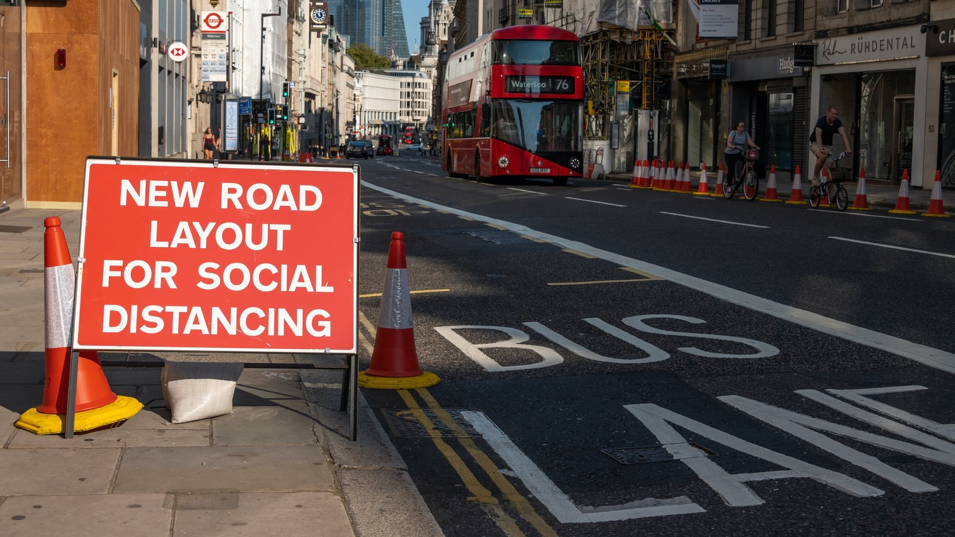
These kinds of mapping projects were the foundation for similar work that combined big data and GIS methodologies during the COVID-19 pandemic. Researchers used phone data to address questions such as the efficacy of social distancing; how confinement measures affected mobility; and how the population outflowfrom Wuhan, China, affected the geographical distribution of infections.

Our planet is experiencing large-scale urban migration. Half of the world’s population currently lives in urban areas, a percentage that will grow to two-thirds by 2050. Those planning the cities of tomorrow use mobility data to understand migration flows and how people interact with the built environment. By analyzing how residents use public spaces, planners learn to design development in a way that helps cities handle growth.
The global pandemic, combined with the need for climate change resilience, has spurred interest in the “15-minute city.” Advanced by scientist Carlos Moreno in 2019, the concept involves designing urban areas in which residents find most amenities near their homes.
A serious consideration of the idea requires knowledge of how people move through cities now. It also requires projections of how changes to the urban landscape might affect these movements.
Phone data by itself provides the raw information, but the visualization capabilities of GIS are crucial. This is especially true when gauging the likely result of planned urban projects.
A recent study applied the 15-minute city concept to Barcelona. It used several sources, including mobile phones, which the study noted generated data “at unprecedented temporal frequency and geographical granularity.”
The ability to analyze and predict movement often has a strong equity component. For instance, to decide which schools to partner with for after-school enrichment programs that would benefit economically diverse neighborhoods, the YMCA mapped out 15-minute walk times for its members in a Chicago branch. Another recent project, adding a new layer of inquiry to some of the earliest movement-based studies, such as the analysis of post-earthquake Port-au-Prince, examined differences in natural disaster evacuation patterns related to race and wealth.

MIT’s Senseable City Lab produced some of the earliest work with phone data and GIS. At the 2006 Venice Biennale, the Senseable City Lab exhibited Real Time Rome, a groundbreaking exercise in “understanding the present and anticipating the future of urban environments.” The project aggregated phone, pedestrian, and vehicle data in Rome, using GIS as a single interface to manage the data and display the interplay of these sources.
“These real-time maps,” the project statement explained, “help us understand how neighborhoods are used in the course of a day, how the distribution of buses and taxis correlates with densities of people, how goods and services are distributed in the city, or how different social groups, such as tourists and residents, inhabit the city.”
Earlier this year, the Senseable City Lab published a paper detailing the results of a project that represents a highwater mark in mobility studies. For the first time, phone data appears to go beyond revealing some truths about certain cities, to reveal a universal truth of all cities.
Since the mid-19th century, geographers have asked whether we can predict how many people will travel between two places if we know the distance between the places and certain facts about them. The Senseable City Lab project added a temporal angle. The question it asked was whether there was some constant to how often someone from one place will visit another.
The results, obtained by analyzing phone data from seven cities and projecting it onto maps, suggest that there is a mathematical formula to the frequency of visitation. In simple terms, visitation frequency decreases the farther a destination is from your home.
“What we have found is that there is a very clear inverse relationship between how far you go and how frequently you go there,” said Paolo Santi, a research scientist at the Senseable City Lab and a coauthor of the new paper. “You only seldom go to faraway places, and usually you tend to visit places close to you more often. It tells us how we organize our lives.”
The math can predict how many visitors any location will have and which locations any person is most likely to visit. The calculation appears to work for any urban area.
In an analysis of the results in Nature, mobility experts Laura Alessandretti and Sune Lehmann declared the result to be nothing less than a “phenomenological law…revealing a pattern that was right in front of you all along—and which makes you want to kick yourself for not noticing it before.”
Explore how GIS analyzes population patterns of human mobility and traffic.