
June 2, 2020 |
June 25, 2020
We are facing a pandemic that brings with it new challenges and new opportunities in the way we respond. One of those new opportunities—community contact tracing—offers a technology-driven update to traditional methods.
First, what is contact tracing? It starts with the understanding that a person’s risk of contracting a virus relates directly to their exposure to other people who are already infected. Contact tracing is a powerful public health tool professionals use to break disease transmission chains, keeping people and populations safer from disease spread. Contact tracing involves a comprehensive process that begins with interviewing those infected with a contagious or communicable disease—someone who is a confirmed Case.
The confirmed Case is interviewed by a person trained to empathetically ask a series of questions about others they have come into contact with over a specified time period. These Contacts are then interviewed to assess symptoms, collect additional information about their exposure, offer resources for testing, and help support the Contact’s quarantine, ensuring a safe, sustainable and effective isolation to prevent additional transmission.
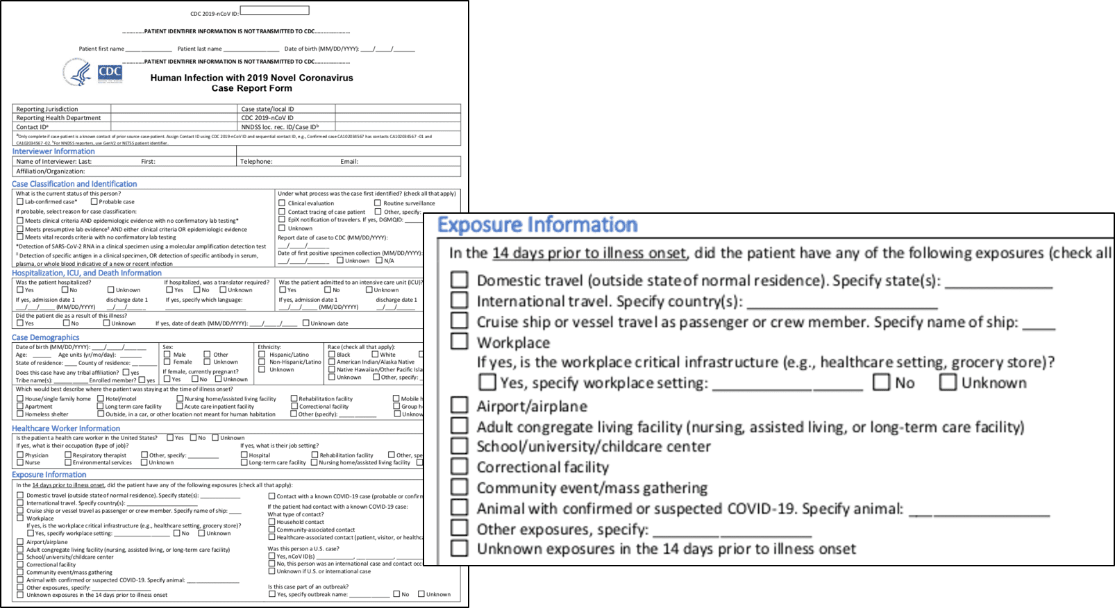
Conventional contact tracing has been a manual process. The Centers for Disease Control and Prevention (CDC) published a standard form and methodology, specifically for the COVID-19 response. Unfortunately, the established process does not typically include the systematic capture of useful location information. To enhance the process of contact tracing, Esri is introducing the concept of Community Contact Tracing.
In the earliest stage of an outbreak, when we observe human-to-human transmission of infection, contact tracing becomes a robust intervention for containment. However, as an outbreak evolves to become a pandemic, transmission advances to community spread—a situation where people infected are not sure how or where they contracted the virus. This is where a location-focused approach can help.
The coronavirus disease 2019 (COVID-19) pandemic is certainly in the community spread phase. And yet, public health authorities around the world are calling for contact tracing to be scaled to an unprecedented level, supporting continued efforts to prevent further spread of the virus. If this effort is to be successful, we’ll all need to think differently.
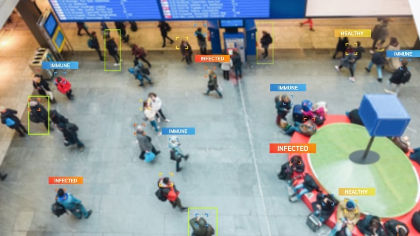
At Esri, we believe the person-to-person approach, inherent in traditional contact tracing, should be expanded to include person-to-person-to-place—a simple innovation with big returns. Including place makes sense in our highly complex, highly mobile and interconnected world. All that is required is the location enablement of contact addresses and community locations during the data collection process.
By adding location information to contact tracing, public health analysts will be able to perform location analytics to illuminate the places where viral spread is happening outside of direct and prolonged contact between two individuals.
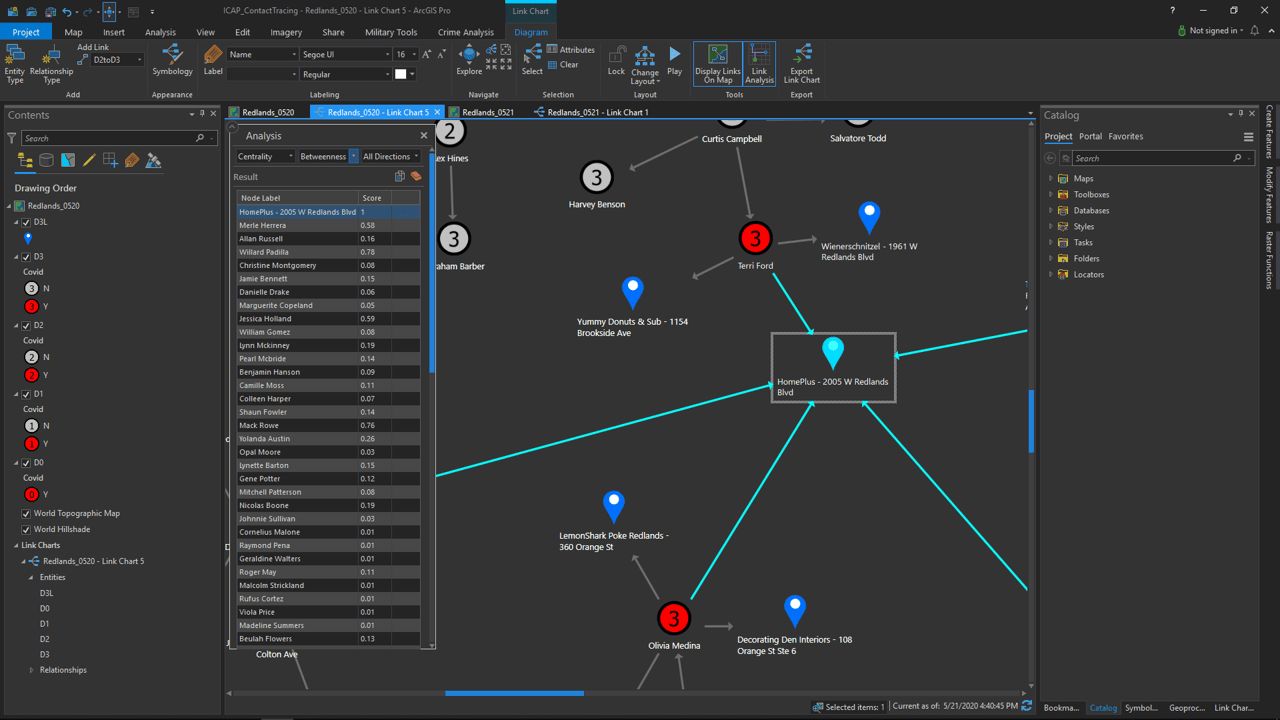
Tools like link analysis and centrality can identify places that may connect Cases and Contacts otherwise unknown to one another. For example, maybe the person who is a confirmed Case shops at the same home improvement store as a Contact. When places of transmission are identified, decision-makers can take action—whether that means focused cleaning and disinfecting or tightening social distancing measures in and around that location.
The 7-minute video below walks through an illustrative example demonstrating spatially-based link analysis and centrality measures that capture the importance of person-to-person-to-place relationships.
As we face the challenges posed by COVID-19, spatial technologies allow us to think differently. Public health professionals are contemplating innovative ways to scale contact tracing efforts, and many are recognizing that community contact tracing uncovers important insights to advance interventions.
Public health departments can use GIS to achieve location enablement and perform location analytics. Location enablement includes managing data in a system of record and digitizing and streamlining data collection. Location analytics involves examining collected data to quickly identify potential contacts and determine where specific cases might originate. With a location-focused supplement to traditional contact tracing, community contact tracing offers increased odds of containing COVID-19 or any other community spread contagion.
A more detailed video demo can be found here. See the COVID-19 GIS Hub for location intelligence resources. The Coronavirus Response solutions page provides a collection of maps and apps that can be used by agencies to understand the virus’s impact and share information about the pandemic with the public.

June 2, 2020 |

April 7, 2020 | Multiple Authors |
May 6, 2020 |