
April 8, 2020 |
Richard Leadbeater | GIS for Good
The GISCorps desperately wanted to help. The volunteer organization, operating under the auspices of the Urban and Regional Information Systems Association (URISA), conducts short-term mapping projects, with an emphasis on underserved communities, humanitarian aid, and disaster relief. As the scope and severity of the coronavirus pandemic continued to grow, these experts in the field of geographic information system (GIS) technology wanted to put their skills to good use.
“There was so much restlessness,” recalled Holly Torpey, a GISCorps volunteer who also does administrative work for the organization. “We were getting so many emails from our members who were like ‘What’s going on? How can I help?'”
As the core committee considered options, the United States was clearly becoming the epicenter of the pandemic. One reason the novel coronavirus had established such a strong foothold was the country’s lack of a testing regimen. There was still widespread confusion regarding where people could—and which people should—get tested for exposure to the virus.
When GISCorps asked Esri about data gaps the volunteers were hearing about through the company’s Disaster Response Program, the idea for a nationwide map data layer with test site locations surfaced. “Everyone was wondering where they could go, but nobody quite knew for sure,” said Erin Arkison, a member of GISCorps’ core committee. “Nobody seemed to have an authoritative database, even for testing in a specific region.”
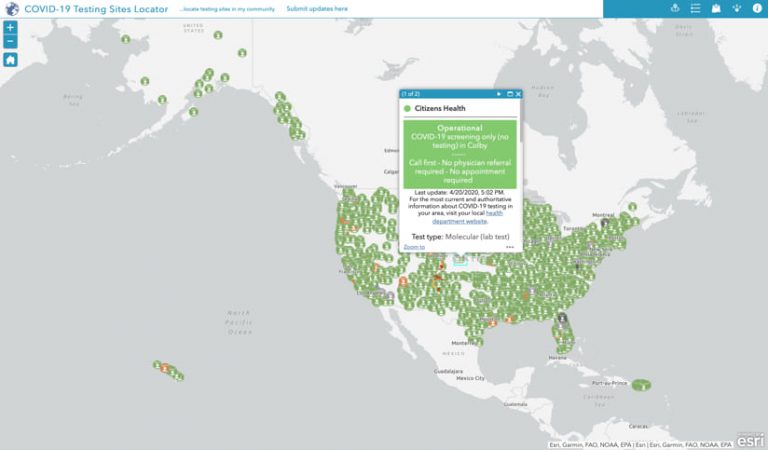
The GISCorps’ response to the pandemic began to take shape. The organization would build the nation’s most complete map of COVID-19 testing sites.
Originally, the committee talked about gathering information about school district closures and free-lunch programs, but it turned out there were other people already taking care of those mapping needs.
“We felt like the information gap was probably biggest on the testing sites, so that’s what we decided to go with,” Arkison said.
Torpey, Arkison, and core committee member Troy Wirth took the lead on the project. On March 25, they sent a letter to around 2,000 of the group’s 6,800 members, targeting those who had relevant experience and are based in the US.
“Everybody was looking for a way to participate,” Torpey said. “So as soon as we sent that out, we instantly got hundreds of responses.”
GISCorps’ project was not the first attempt to build a nationwide map of COVID-19 testing sites. Coders Against COVID, an ad hoc group of computer experts and medical professionals, had already made a valiant attempt with its website findcovidtesting.com. “They didn’t have the huge volunteer database that we have, so they’d kind of hit a wall,” Torpey said.
GISCorps had its army of GIS pros ready for action, but the logistics proved daunting. To help get the project up and running, the core committee “deputized a couple of star volunteers,” Torpey said. Nadine Trahan and Christina Brunsvold organized responses and liaised with Coders Against COVID.
The two organizations connected their respective datasets via web services to aggregate all efforts into a master database that both can use. This linkage means that any updates either organization makes appear on both maps. By late April, the maps included 3,400 testing sites. (Jorge Caballero, a physician and co-founder of Coders Against COVID, continues to work closely with GISCorps, offering medical advice and other guidance.)
The decentralized nature of the nation’s public health system is a major hurdle—even among states where testing has been comparably prevalent. “Within the state, some counties may be doing less or more of it,” Arkison explained. “And don’t forget the individual cities and municipalities. So, it’s a constantly evolving back end process.”
“The project team asked each volunteer to adopt one or more counties that they were already familiar with,” Torpey said. “So the people who are actually getting the messaging from their local county are the ones who are making the updates on the map.”
Many of the volunteers are uniquely positioned to receive up-to-date information. “We have a lot of members who work in government, including health departments on the county or state level,” Torpey said. “They have connections within these organizations, so they’re better informed than a lot of people.”
Besides bringing their own knowledge to the map, the GISCorps volunteers involved with the project also function as editors. Any members of the public who want to add new testing sites to the map or change the information on sites already on the map can fill out a survey form.
“If someone sends in a submission, a volunteer in that area will see it on the map,” Torpey explains. “The volunteer can click on it, review the data, and if it’s valid, they can add it to the testing sites layer.”
The map offers ancillary benefits. If health officials in counties offering testing notice their sites are absent from the map, they may realize they need to publicize them more. The full dataset (including sites with restricted testing, sites that have closed or are scheduled to come online but aren’t yet open) is also available as a web service so federal and state agencies and NGOs can use it for analysis, capacity assessment, and resource allocation purposes.
“We don’t want to replace health departments in their role of communicating to the public,” Torpey explains. “We just want to help get their message out.”
See the COVID-19 GIS Hub for location intelligence resources. The Coronavirus Response solutions page provides a collection of maps and apps that can be used by agencies to understand the virus’s impact and share information about the pandemic with the public.