

I was shocked. This place was special. It was one of the areas we worked so hard to protect . . . but it was not enough.
Dr. Pablo “Popi” Garcia Borboroglu
Founder and President of the Global Penguin Society
September 3, 2025
Penguins split their lives between land and sea, adapting with tenacity to the growing threats they face in both worlds. When those threats become too great, the people working to protect penguins are equally tenacious. Such was the case following a deeply disturbing act of environmental destruction along Argentina’s central coast.
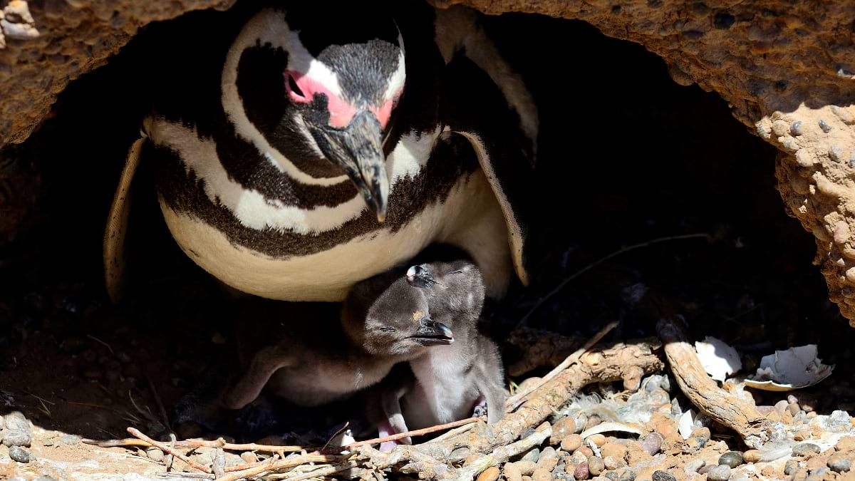
A local rancher bulldozed a road through a Magellanic penguin nesting ground, harming three colonies near the Punta Tombo Natural Protected Area. More than 175 nests were destroyed, and over 100 penguins were crushed, including vulnerable chicks.
News of the destruction, dubbed the “Punta Tombo Penguin Massacre,” quickly went viral near the end of 2021. What unfolded next was a yearslong battle for retribution and protection aided by sophisticated technology and legal handiwork.
Historically, environmental crimes in Argentina rarely reach the courtroom. But this case struck a nerve. The evidence was extensive, and the damage was clear. In a landmark ruling, the rancher became the first person in Argentina convicted of aggravated environmental damage, animal cruelty, and malice (commonly referred to as ecocide). This verdict set a new standard for conservation and environmental justice in South America. It also helped expand natural protections in the region, benefiting not just penguins but a menagerie of local wildlife.
Bringing the case to trial—and winning—took the dogged efforts of conservationists, scientists, government officials, and prosecutors. Central to the prosecution’s case was powerful analysis from geographic information system (GIS) technology.
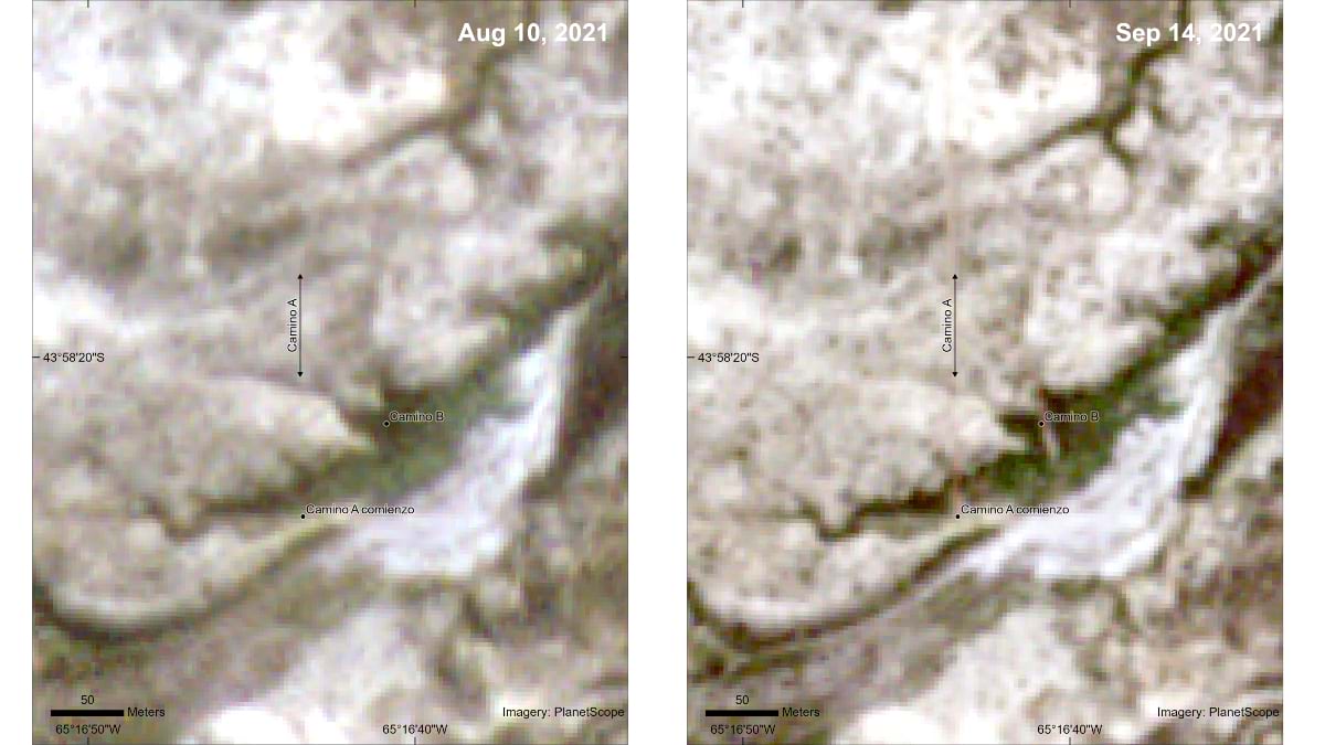
Using GIS, experts analyzed satellite imagery of the incident site at Punta Tombo and created a visual timeline that contradicted the defendant’s claim that no penguins were present at the time of the incident. The maps and satellite evidence made both the damage and timing undeniable—and set a new precedent for how technology can support environmental justice.
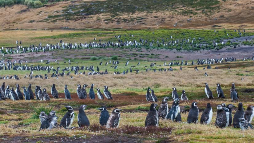
National Geographic Explorer and Global Penguin Society (GPS) founder Dr. Pablo “Popi” Garcia Borboroglu was one of the first people to assess the carnage at the nesting grounds near Punta Tombo. This critical habitat is home to the world’s second-largest Magellanic penguin colony.
Borboroglu and GPS conservation director Laura M. Reyes were on-site at another penguin colony in November 2021 when they received a call from the Minister of Tourism and Protected Areas. A ministry official reported “a large movement of earth” at Punta Tombo.
Within hours, Borboroglu and Reyes reached the scene. What they found was alarming: collapsed burrows, dead chicks, and a scarred landscape where life had once thrived.
I was shocked. This place was special. It was one of the areas we worked so hard to protect . . . but it was not enough.
Borboroglu had helped create the Punta Tombo Natural Protected Area and played a major part in establishing UNESCO’s Patagonia Azul Biosphere Reserve. The massacre occurred within the core zone of this reserve.
Borboroglu and Reyes immediately began assessing the site, taking measurements, photos, and videos. An 18-foot-wide road cut along one mile of the nesting ground. They sent images to the tourism minister who had alerted them to the damage. Over the next few weeks, they created detailed reports of their findings.
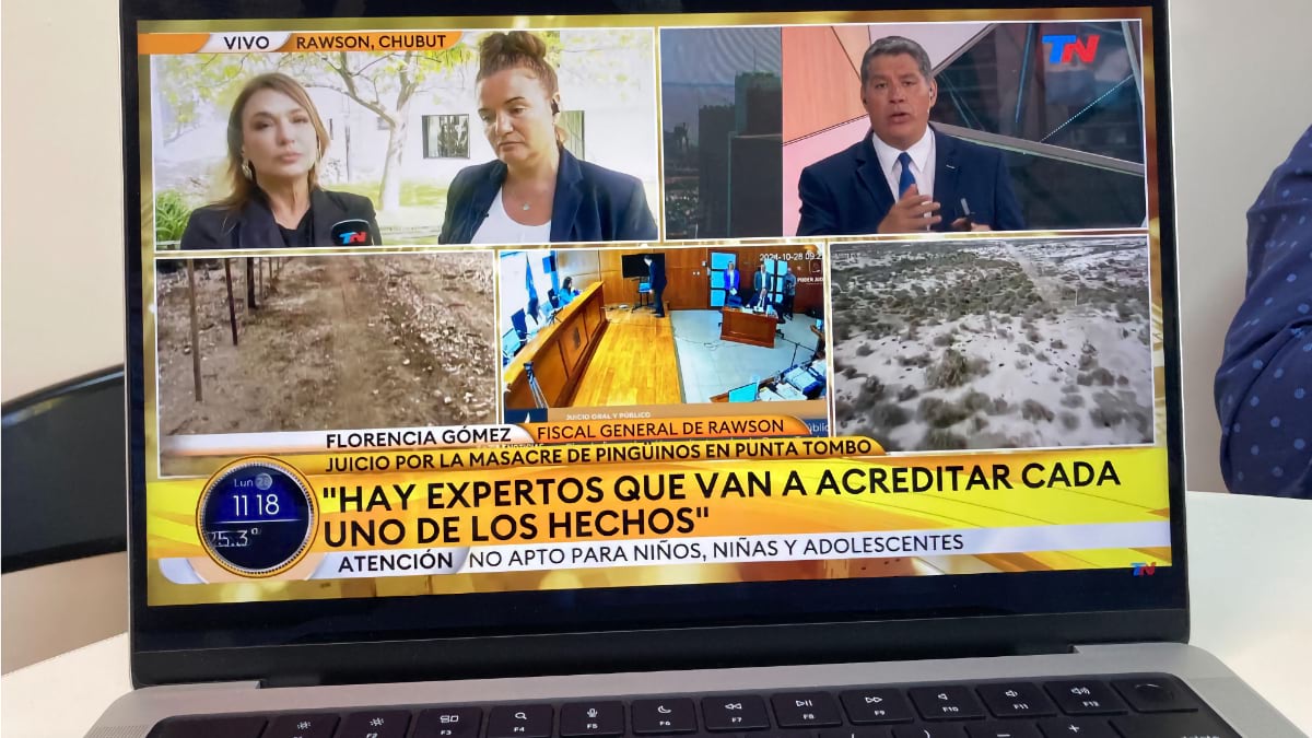
The Ministry of Tourism and Protected Areas sent the reports to the Ministry of Justice. Prosecutor Dr. Florencia Gómez took over the investigation, gathering evidence and presenting the case in court.
“In Argentina, wildlife is a public trust resource,” Borboroglu said. “That’s why the government took the case to the justice system.”
Bringing the case to trial was a difficult process spanning three years. Media outlets and political opponents publicly criticized the penguin advocates.
“There were fake influencers pretending to be environmental experts, trying to throw dust on us, the trial, and the prosecutor,” Borboroglu said. “We were never in hell like this. But we’ve dedicated our lives to improving the lives of the penguins . . . We stuck to our truth.”
Prosecutor Gomez had collected extensive evidence through multiple site visits. She consulted experts on soils and vegetation and conducted drone surveys. Borboroglu even toured the site with the panel of judges and both legal teams.
But establishing a concrete timeline became critical. The prosecution needed to definitively prove when the damage occurred—demonstrating that penguins were present during road construction—a fact the defendant denied.
The case hinged on proving deliberate cruelty. Magellanic penguins are migratory, with breeding pairs returning to Punta Tombo each spring to nest and raise their young. The rancher said he had built his road before the penguins arrived for the season.
To establish this crucial timeline, the prosecution contacted Borboroglu’s colleague Sam Guilford, GIS and mapping manager at the National Geographic Society. Guilford set out to collect and analyze satellite imagery that would pinpoint when the road appeared.
Guilford began by sourcing historical imagery, gathering images of the nesting ground and surrounding area from August to December 2021. He then narrowed the time frame systematically until he had identified the clearest, cloud-free images showing the area just before and after the road appeared.
“I could see the straight lines of the road,” Guilford said. “Obviously, it wasn’t naturally occurring . . . you could tell that it was manmade.”
With guidance from National Geographic colleagues experienced in using mapping data as legal evidence, Guilford compiled his findings into a detailed report. He submitted the document during the trial and testified as an expert witness.
“According to the prosecutor, this was the first use of satellite imagery as evidence in a trial in Argentina,” Guilford said. “Even for people who weren’t used to looking at satellite imagery, or using it as evidence in a case, this was a very tangible way for them to see exactly when the road appeared.”
The court’s decision marked a historic milestone: Argentina’s first conviction for ecocide. The rancher was found guilty, but the impact has extended far beyond punishing the perpetrator. The Argentine government expanded the Punta Tombo Natural Protected Area from 500 acres to nearly 4,000 acres—a significant development for the more than 360,000 penguins that nest there each year.
Additionally, a new environmental prosecutor’s office was established in Patagonia, led by Gómez, the lead prosecutor in the penguin trial.
The Punta Tombo case has become a powerful example of how GIS can support not just conservation science, but environmental justice. Prosecutors across Argentina are now requesting satellite imagery and spatial analysis for other cases. Legal professionals, policymakers, and scientists are recognizing the value of geographic evidence in holding perpetrators accountable and protecting vulnerable ecosystems. “It’s now a new tool for justice here,” Borboroglu said.
Borboroglu’s team continues to use GIS and satellite tracking to monitor penguin colonies and migratory routes, informing new marine protected areas and guiding international conservation efforts. And thanks to this case, their voices are being heard more than ever.
“This was a war,” Borboroglu said. “And we won.”
Learn more about how GIS helps protect biodiversity and put nature on a path to recovery.