Explore what’s new in the latest ArcGIS release.

ArcGIS Enterprise
One of the most valuable updates at this release is two-way sync using distributed collaboration. With two-way sync, Enterprise customers can copy feature layers to another Enterprise organization or to ArcGIS Online and sync data edits back and forth. This allows organizations to work closer together to maintain up-to-date datasets.
Here are a few other new features and capabilities of interest:
- A new home page editor helps you customize your home pages using a flexible set of components that is responsive on desktop and mobile devices.
- New administrative reports let administrators export inventories of items and members for a better picture of content and users in their organization.
- ArcGIS Enterprise on Kubernetes is now available. To find out more about this new cloud-native offering, check out this blog or reach out to your Esri representative.
For more details on the ArcGIS Enterprise 10.9 release, visit the ArcGIS Blog.
ArcGIS Mission
The latest release of ArcGIS Mission enhances the functionality in the ArcGIS Mission Manager web app, extends peer-to-peer capabilities in the ArcGIS Mission Responder mobile app, and introduces an API for automating missions with ArcGIS Mission Server. For more details, see What’s New in ArcGIS Mission.

ArcGIS Pro Intelligence
ArcGIS Pro Intelligence is built for intelligence analysts using maps, imagery, link analysis, timelines, and graphs to uncover patterns, trends, and relationships to inform decision-making. The 2021 Q2 release of ArcGIS Pro Intelligence introduces new tools for analysts supporting investigations. Cellular call analysis, movement analysis, incident analysis, and finding complex and hidden relationships in your data through link analysis all just became easier. Register for the release webinar series to learn more.
ArcGIS Excalibur
The ArcGIS Q2 2021 release of ArcGIS Excalibur delivers a wide range of exciting new capabilities that enhance observation management workflows, including a new, interactive tabular view of observation and context features, and a way to quickly navigate to a location on an image or map.
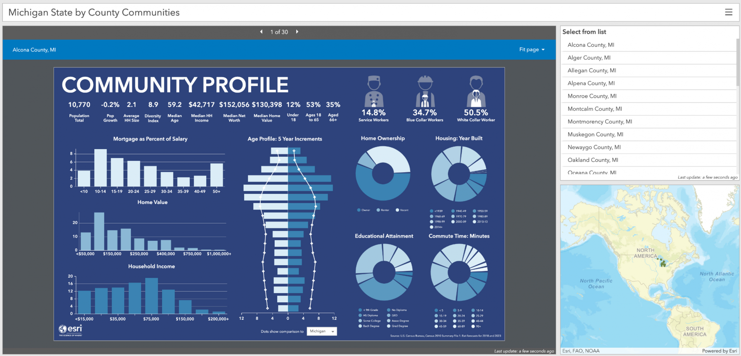
ArcGIS Business Analyst
Two big updates have arrived for ArcGIS Business Analyst in the ArcGIS 2021 Q2 release. With this release of ArcGIS Business Analyst Web and Mobile Apps, we’ve been focused on making it even easier to share your analysis with your teams. Updates include a new ArcGIS Dashboards workflow, improved Custom Data Setup, curating content, exporting data to Microsoft Excel from infographics, dark mode in Business Analyst Mobile App, and data updates. For ArcGIS Business Analyst Pro, the team focused on improving performance and productivity. Updates include the addition of a popular AcMap extension to Business Analyst Pro, a new integration with Business Analyst Web App, new scenario planning tools in territory design, and more.
To read more about the update to ArcGIS Business Analyst Web App, dive into the story by clicking here. To read more about the update to ArcGIS Business Analyst Pro, read our blog.
ArcGIS Earth
A new release of ArcGIS Earth is now available to download. This is a major release for ArcGIS Earth on desktop, bringing users more capabilities for sharing data as well as configuration settings—from mobile, to desktop, to the organization portal. A new release of the ArcGIS Earth mobile app is also available now, with minor enhancements. Find all the release highlights here.
Also, a new blog post offering a step-by-step guide to using 3D symbology in ArcGIS Earth is now available. This tutorial employs an example use case of tracking COVID-19 spread in the U.S. using real historical data, and offers a thorough walkthrough for users who want to incorporate 3D symbology into their analysis workflows. This blog post has also been included in the ArcGIS Earth discovery path.
ArcGIS LocateXT
Get an overview of how to use ArcGIS LocateXT, a powerful extension for ArcGIS Enterprise that closes the gap between big data and geographic analysis. Users can drag and drop entire folders of data, including PDFs, text files, PPTs, spreadsheets, geotagged images, and even social media posts, which ArcGIS LocateXT will scan for any location information\ and plot it a map, saving hundreds of work hours in manual analysis. See how it works on our blog.
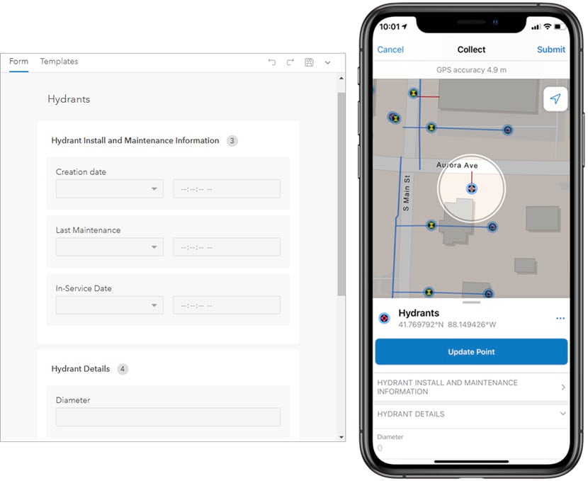
ArcGIS Field Maps
ArcGIS Field Maps is a new mobile app solution that allows you to streamline field workflows and take maps anywhere. You can use Field Maps to explore the maps you make in ArcGIS, collect and update your authoritative data, and record where you’ve gone, all within a single location-aware app.
Field Maps includes a companion web app that is embedded with ArcGIS Enterprise 10.9 and later. The web app allows you to configure the maps mobile workers use in the field.
The Field Maps web app on ArcGIS Enterprise simplifies the configuration and deployment of maps with the following capabilities:
- Author smart forms for data collection
- Enable web maps for offline use
- Manage feature templates
- Configure sharing settings
- Hide maps from the Field Maps mobile app
For more information, see What’s New in Field Maps.
ArcGIS Solutions
ArcGIS Solutions are currently available in ArcGIS Online and will soon be available in ArcGIS Enterprise 10.9. ArcGIS Solutions is a collection of focused maps and apps that directly address challenges in your organization. They leverage your authoritative data to improve operations, provide meaningful insight, and enhance the services you provide. Built for many industries, these out-of-the-box solutions will save you time and effort in deploying, configuring and delivering success using ArcGIS in your organization or company.
Follow these steps to get immediate results:
- Identify your solution – Explore the collection of ArcGIS Solutions that will manage your data, provide insight, and deliver key capabilities to your stakeholders.
- Deploy your solution – Quickly deploy ArcGIS Solutions to your ArcGIS organization, configure them to meet your needs, and load your authoritative data.
Visit this page to get started with ArcGIS Solutions.
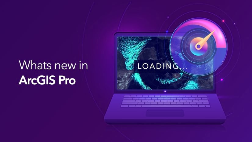
ArcGIS Pro
As part of the ArcGIS 2021 Q2 release, ArcGIS Pro enables users to expand their GIS abilities with all-new capabilities, performance, and productivity improvements. You can now export layouts as accessible .pdf files and export layouts as accessible .pdf files. Catch up on all the new features within ArcGIS Pro through our What’s New in ArcGIS Pro 2.8 video, or check out this blog post to discover just a few highlights of this recent update.


Article Discussion: