ArcGIS Enterprise 11.2 is here on Windows and Linux! It is part of the ArcGIS 2023 Q4 release and is available to all customers up to date on maintenance. This short-term support release builds upon what was introduced in 11.1, with new enhancements, features, and functionality throughout the software.
This blog will cover the highlights of this release from the Enterprise portal, content and data management, and administration to apps and ArcGIS Server roles. For a comprehensive view into everything included with this release, take a look at the What’s new in ArcGIS Enterprise help topic in the product documentation and our what’s new in ArcGIS Enterprise 11.2 video.
In addition, check the ArcGIS Blog site for additional blogs covering specific features in depth.

ArcGIS Enterprise portal
This latest release includes many updates that you will see throughout your ArcGIS Enterprise organization.
Map Viewer updates
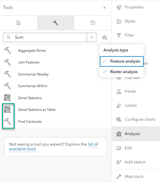
Map Viewer includes new features introduced in the ArcGIS Online February 2023 and June 2023 updates. The biggest highlight of these new features that we’re excited about is the inclusion of spatial and raster analysis tools that were previously only available in Map Viewer Classic.
These tools allow you to quantify patterns and relationships in data. You can browse or search for specific tools, set environment settings for an individual tool or a web map, and access a history showing which tools have been run, their results, the parameters used, and any errors or warnings. When you save your map, the tool history is saved with it, allowing others to view job details and reopen tool parameters when you share the map with them.
This release of analysis tools is a first iteration, more tools will be added in future releases. Refer to product documentation for details about available analysis tools in Map Viewer in this latest release.
This latest release also includes the ability to configure and view related records in pop ups, the ability to display scatter plots, improvements to item browsing, and more. Be sure to take a look at the Map Viewer section in the Enterprise product documentation for a comprehensive list of all the Map Viewer updates.
Scene Viewer updates
This release of ArcGIS Enterprise incudes Scene Viewer updates to help show off your 3D data to your organization. Scene Viewer highlights include:
- Snap to features while measuring in Scene Viewer.
- Voxel layers support pop-ups, and you can use the slice tool to explore voxel data further.
- Append custom request parameters for supported layers in Scene Viewer.
- Terrain is improved with enhanced shading and higher resolution for elevation.
- See high-quality visuals such as water reflections, better shading, and sharper labels automatically on all devices and in all ArcGIS web apps.
- Fine-tune the point density for a point cloud layer in Scene Viewer.

Metadata editor (beta feature)
A new metadata editor is available as a beta feature in ArcGIS Enterprise 11.2. It must be enabled for the organization by an administrator. If enabled, an option is added to the Metadata button that allows members to edit an item’s metadata in the metadata editor.

Please keep in mind, as a beta feature, the metadata editor is bound to the rules and considerations associated with beta features in ArcGIS Enterprise. For more about the new metadata editor and what it means as a beta feature, take a look at our Beta features in ArcGIS Enterprise 11.2 blog.

Content and data management
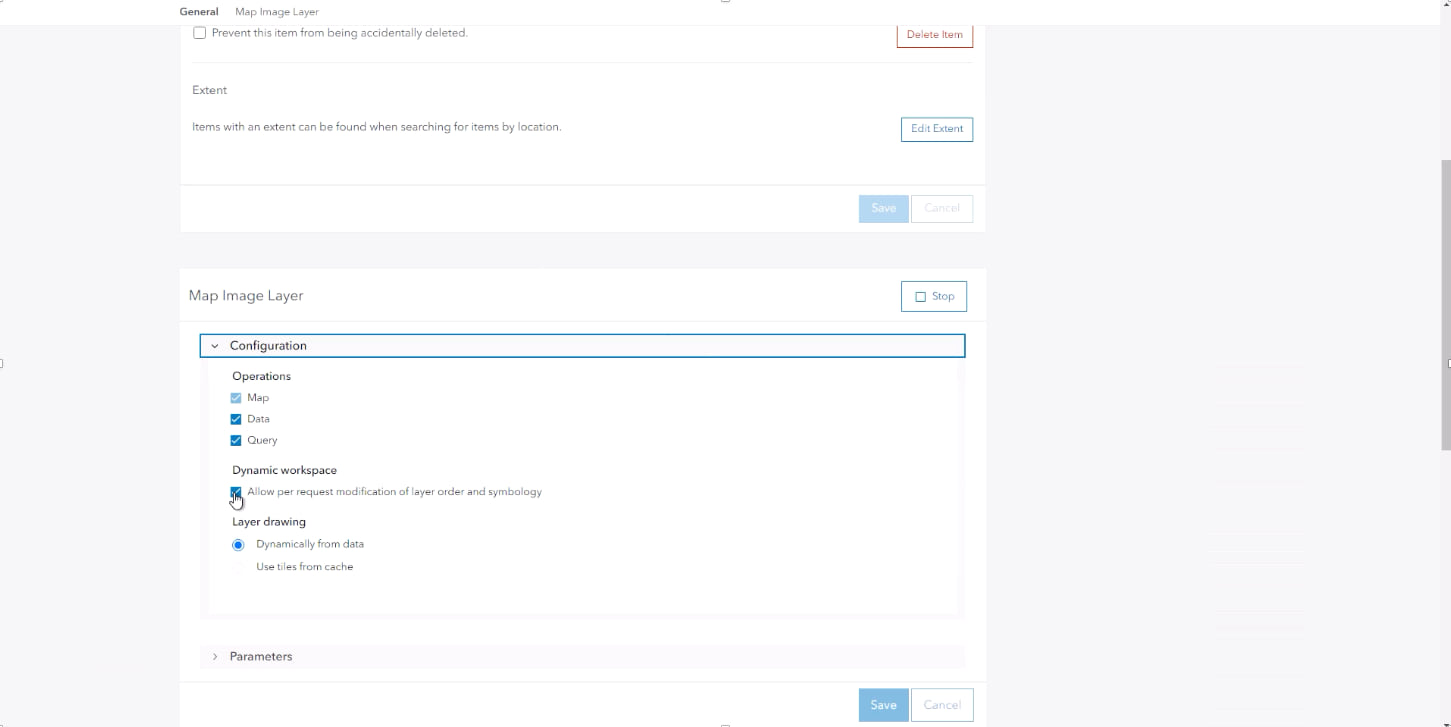
Manage services in the Enterprise portal
You can now manage map services and feature services in the Enterprise portal. Prior to this release, all services referencing user-managed data stores had to be managed through ArcGIS Server Manager. This meant that if you ever wanted to enable additional operations or restart the service, you’d likely have to open a new tab in your web browser. While all of these operations will remain accessible in ArcGIS Server Manager, now these workflows can also be done directly in the Enterprise portal through the item details page.
Updates to hosted feature layers
When creating new hosted feature layer from a CSV, you now have the ability to remove fields and update field names when publishing. These layers now also support overwriting.
Additionally, hosted feature layers can now be exported to a KML file. These files can be shared and used by other members of your organization and beyond – regardless of if they’re looking to add this content to ArcGIS software or elsewhere.

The workflow to update data for hosted feature layers just got easier! In this release, the item page for a hosted feature layer shows a single update data button, before providing the option to choose to add features, update features, or add and update features. This workflow is more streamlined than in previous releases.
Lastly, you can also provide users with a single layer that presents dynamic data from two separate hosted feature or table layers.
Updates to data store items
This latest release of ArcGIS Enterprise introduces a new and improved experience for when adding a data store item.
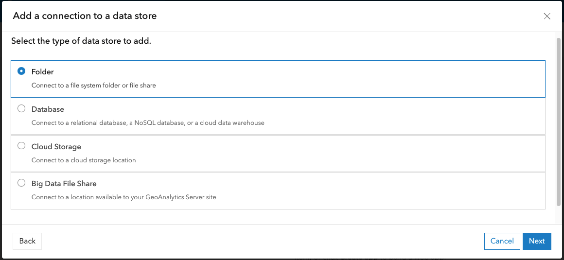
If using ArcGIS Knowledge, you may notice that there is now a NoSQL data store option included when adding database data store item. The NoSQL option also now supports connecting to user-managed ArangoDB instances.
ArcGIS Data Store updates
The ArcGIS Data Store comes in a few different configuration types, each used for a different purpose. The graph store, used by ArcGIS Knowledge Server, can now be configured to be highly available. To implement a highly available graph data store, simply add a second graph store machine to your system. Another new enhancement to the graph store is support for writing backups to cloud storage, with support for Amazon Simple Storage Service (S3) bucket or Microsoft Azure Blob storage containers.
ArcGIS Video Server, new in 11.2, uses the object store to store video data. Because of this, we have added support to configure backups of the object store, to protect against data loss, and have also updated the Data Store Configuration wizard to add the option to deploy the object store in single-machine mode or cluster mode.
New field types (beta feature)
ArcGIS Enterprise 11.2 includes four new field types for data: data only, time only, timestamp offset, and big integer. These new field types provide further refinements to handling date and time data.
Please keep in mind, as a beta feature, the new field types bound to the rules and considerations associated with beta features in ArcGIS Enterprise. For more about the new field types and what it means as beta features, take a look at our Beta features in ArcGIS Enterprise 11.2 blog.
Administration
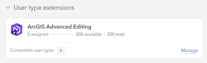
Advanced editing user type extension
The ArcGIS Advanced Editing user type extension is new at Enterprise 11.2. This new type of user type extension provides access to advanced geodatabase functionality and frameworks. This user type extension replaces the ArcGIS Utility Network, ArcGIS Parcel Fabric and ArcGIS Trace Network user type extensions that were licensed at previous releases. Be sure to read the blog Introducing the ArcGIS Advanced user type extension for more information on this.
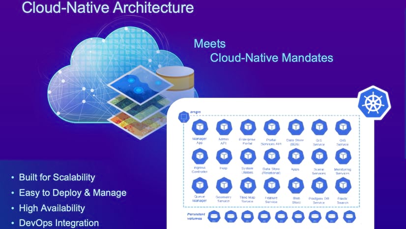
ArcGIS Enterprise on Kubernetes
ArcGIS Raster Analytics on Kubernetes
ArcGIS Enterprise 11.2 on Kubernetes will enable you to license raster analytics with distributed processing, running as a service within the Kubernetes deployment. Running deep learning, analytics tools and raster functions within Kubernetes is a perfect fit for the technology. Raster analytics work is typically batched and requires a burst in resources, and the need to scale quickly. These workloads may also require specialized hardware such as GPUs and the 11.2 release will enable node affinity, the ability to assign pods to run on specific worker nodes, with minimal administrative effort. ArcGIS Raster Analytics on Kubernetes requires an add-on license to an annual subscription for ArcGIS Enterprise on Kubernetes.
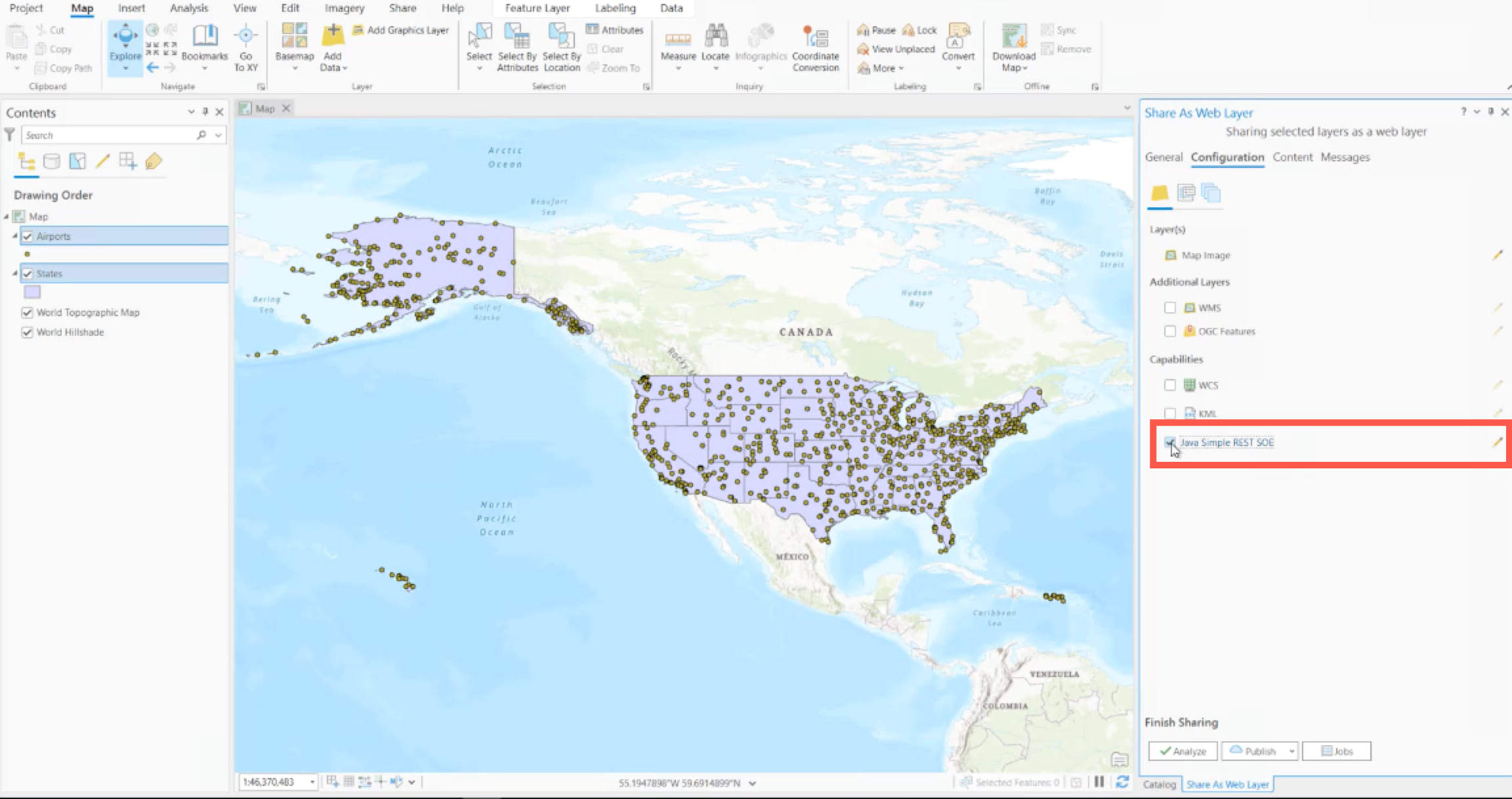
Server object extensions
Server object extensions let you enable additional operations on services, exposed through REST, through customization written in Java. They are now available for ArcGIS Enterprise on Kubernetes map services. For this release, they must be enabled when sharing the service from ArcGIS Pro.
Cloud-native object store
Customers that are deploying ArcGIS Enterprise on Kubernetes have a new configuration option available in the 11.2 release on Kubernetes which is the ability to register a cloud-native storage service from Amazon S3, Azure Blob, or Google Cloud Store to serve as the system’s managed object store. In ArcGIS Enterprise, the system-managed object store supports data such as the portal content directory, results from geoprocessing services, the caches used to optimize hosted feature layers, and the caches used to power hosted imagery layers, vector tile layers, and scene layers in the Enterprise portal. Adding cloud-native support for the object store provides customers with more flexibility to fully leverage the cloud-native services offered by their respective cloud provider.
Supported Environment Expansion
In ArcGIS Enterprise 11.2 on Kubernetes, two new supported environments are available. Rancher RKE and RKE2 support opens more opportunities for you, the customer, to use Kubernetes. ArcGIS Enterprise 11.2 on Kubernetes will also support OpenShift running over AWS/Azure (ROSA and ARO). Now, organizations have increased flexibility to decide where to host their Red Hat OpenShift clusters.
There is one thing that hasn’t changed; Esri still tests the environments, provides patches, and ensures our ArcGIS software runs with the same performance and consistent experience on our listed supported environments.
Visit our documentation to dive deep into what’s new in ArcGIS Enterprise 11.2 on Kubernetes.
ArcGIS Enterprise server roles
ArcGIS GeoAnalytics Server
With ArcGIS GeoAnalytics Server 11.2, in ArcGIS REST API and ArcGIS Pro, the Aggregate Points tool has been enhanced to support H3 bins and the Join Features tool has been enhanced to support the calculation of the distance and time gap between joined features.
You can now register Microsoft Azure Data Lake Gen2 sourced big data file shares from the contents page. Big data file shares enable users to keep data in an accessible location until they are ready to perform analysis, continue to add data to an existing dataset without reregistering or publishing the data, and allow for multiple time formats on a single dataset.
Learn more in the What’s new in ArcGIS Geo Analytics Server product documentation.
ArcGIS GeoEvent Server
ArcGIS GeoEvent Server 11.2 includes new integration capabilities with add-on components, expanded analysis capabilities, improved usability and performance, and stability enhancements throughout the product. In 11.2 GeoEvent Definitions can now be manually created and edited as part of the configuration process for input connectors.
Also, the following add-ons were updated and can be used with GeoEvent Server 11.2 and earlier:
- Cityworks Connector for GeoEvent Server
- FlightAware Connector for GeoEvent Server
- Waze Connector for GeoEvent Server
Learn more about updates and enhancements available to you with ArcGIS GeoEvent Server 11.2 in the product documentation.
ArcGIS Image Server
At 11.2, twenty-eight raster analysis tools have been added to the terrain, deep learning, and multidimensional analysis categories.
Explore new features and functionality in the product documentation.
ArcGIS Knowledge Server
ArcGIS Knowledge Studio will also be available as a beta feature in 11.2. Knowledge Studio is a web application that allows you to explore the contents of a knowledge graph in your web browser. To receive support or provide feedback for Knowledge Studio, check out their dedicated Early Adopter Community and the beta features blog. Please keep in mind, Knowledge Studio is bound to the rules of all beta features in ArcGIS Enterprise.
Learn more in our documentation.
ArcGIS Notebook Server
Features and enhancements in Enterprise 11.2 include user experience and sharing improvements. Users can now import code snippets into a snippet library and export a snippet library as .py files, a new UI/UX to manage scheduled tasks from within the Notebooks home page, and the Notebooks home page has a new UI/UX to manage notebooks, scheduled tasks, and access the Notebook Server Manager (depending on the user’s role/privileges).
Explore more new features and functionality in our documentation.
ArcGIS Video Server
ArcGIS Video Server is a new server role for ArcGIS Enterprise that enables indexing, searching, and publishing, and streaming video as a service with geospatial and temporal context. The core capabilities include:
- Publish video over the web and extend access to them across ArcGIS.
- Search by location, time, and metadata to quickly find or discover videos.
- Pair with client apps, like ArcGIS Excalibur, ArcGIS Pro with Image Analyst Extension, and ArcGIS AllSource, to extract and analyze information. One or more of these client apps is necessary to use ArcGIS Video Server.
- Steam live video feeds for near real-time insights.
Explore more new features and functionality in our documentation.
ArcGIS Workflow Manager
In ArcGIS Workflow Manager 11.2 The Diagrams tab features new ways to manage workflows. Review and compare changes using the Active/Draft toggle button, or Discard Drafts without affecting your active diagram. Also, automated email notifications for job activities are now available with a Workflow Manager Standard server role license to streamline workflows.
Explore more new features and functionality in our documentation.
ArcGIS Mission
ArcGIS Mission 11.2, packed with new features and enhancements to further empower your mission planning and execution. Broadcast Notifications allows for important information to be disseminated to all mission members in a straightforward manner. Once your field team is in the know, the new Responder Navigation feature will enable users to get quick and accurate directions to areas of need, improving response time and overall mission effectiveness.
Explore more new features and enhancements in our documentation.
App updates
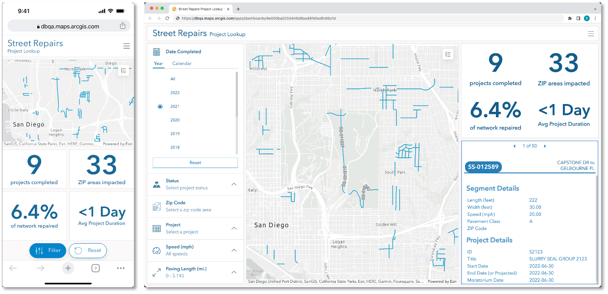
ArcGIS Dashboards
Users often interact with dashboards on a variety of devices. With ArcGIS Enterprise 11.2, you now have the ability to configure both a desktop and mobile view for ArcGIS Dashboards. Each view can be optimized for either a desktop or mobile device allowing you the flexibility to use the same elements as your desktop view, or new dashboard elements, to configure a mobile view that supports your viewers wherever their work takes them.
In addition to new dashboard views, a few other enhancements that simplify and optimize the ArcGIS Dashboard user experience include the Find My Location option, Compass option, accessibility improvements, and layer action configuration that eliminates the need for separate selection tools.
Learn more about these enhancements, and others, in this ArcGIS Blog.
ArcGIS Enterprise Sites
With this release, enjoy features and enhancements that enable you to configure permissions and discovery at a more granular level. Now, Site managers can precisely distribute editing access for individual pages, preview how site and page drafts will display on different devices, and even optimize how sites and pages appear in search results with meta tags.
Explore more updates in this ArcGIS blog.
ArcGIS Experience Builder
In the November 2023 release new widgets in ArcGIS Experience Builder allow you to change basemaps, use interactive infographics with ArcGIS Business Analyst, and compare different layers and maps with just a swipe. In addition to new widgets, new templates are available to customize and structure your apps. Like the Blank Window template, which provides an empty template for users to customize as they build their apps; while the new Frame template features a framed design that provides a sense of boundaries and structure to you app.
Learn more about the latest ArcGIS Experience Builder features and enhancements available to you in this ArcGIS Blog.
ArcGIS Instant Apps
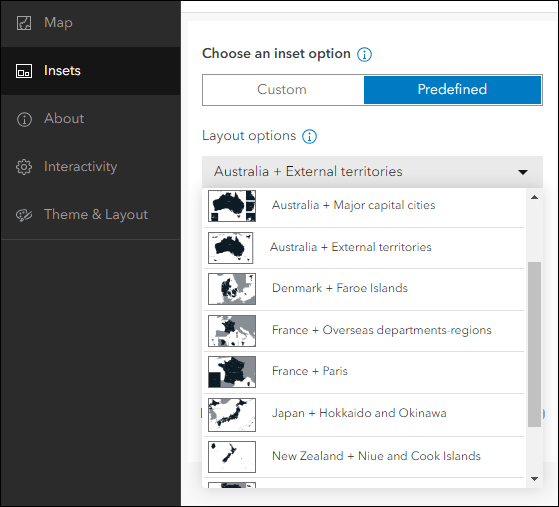
The Create tab now includes a Details view that enables you to read the app description and see example use cases while browsing the all the existing and new app templates available to you. Among the new templates available in ArcGIS Enterprise 11.2 is Insets. Using Insets, you can display noncontiguous geographic locations within a single app layout so users can interact with data in multiple locations at once.
Learn more in our product documentation.
ArcGIS StoryMaps
ArcGIS StoryMaps briefings are available as a beta feature in ArcGIS Enterprise 11.2. Briefings offer a slide-based output that seamlessly integrates dynamic maps, data, multimedia, and more from your organization to create interactive stories. Also, with the complementary briefings tablet app users can view and present briefings anytime, anywhere, even offline. As a beta feature, usage is subject to the rules of Beta features in ArcGIS Enterprise and feedback and support will be managed through the ArcGIS StoryMaps Esri Community or the in-app feedback form.

Keep in mind, as a beta feature, StoryMaps Briefings bound to the rules and considerations associated with beta features in ArcGIS Enterprise. For more about the StoryMaps Briefings, be sure to take a look at the blog.
Get started with 11.2
We hope that you’re as excited about this release as we are. For even more details on what is included with this release, check out the documentation available in the What’s new in ArcGIS Enterprise topic.
When you’re ready to get started with ArcGIS Enterprise 11.2, head over to the My Esri website for your licenses and software. We’d love to hear what you think of this latest release of Enterprise in our Esri Community space!


Commenting is not enabled for this article.