The June 2023 release for ArcGIS Experience Builder in ArcGIS Online introduces many new features to help you easily build no-code and low-code web apps and pages.
We’ve added three new widgets – Near Me (beta), Swipe, and Basemap Gallery. The Near Me widget consolidates capabilities from five Web AppBuilder widgets including Situation Awareness and Info Summary. Other highly anticipated improvements include the Search widget allowing you to search without filtering layers, the Map Layers widget supporting both the View in table data action and legends, the Widget Controller widget enabling you to open all contained widgets in a fixed position and size, the Chart widget supporting the date field and grouped features, and the Survey widget allowing you to answer questions by selecting a feature in any widget connected to same data, not just a map. Additionally, Experience Builder now supports accessibility. Let’s dive into these features.
Near Me (beta)
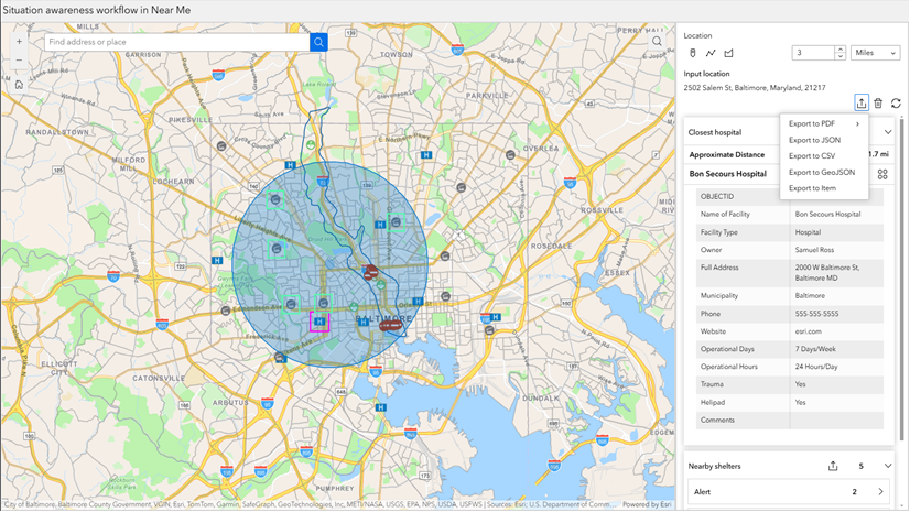
The new Near Me (beta) widget allows you to find and analyze features within a certain distance of a location. This “super” widget consolidates capabilities from five Web AppBuilder widgets – Near Me, Situation Awareness, Screening, Info Summary, and Incident Analysis.

Analysis types
The widget provides three analysis types as shown below. Each analysis targets a specific workflow. You can configure the widget with one or multiple analysis types.

Proximity is designed for the workflow of the Web AppBuilder Near Me widget. For more information, see the Recreating Web AppBuilder Near Me widget workflows in Experience Builder blog.
The combination of Proximity, Closest Feature, and Summary enables you to create workflows of the Web AppBuilder Situation Awareness widget. For more information, see the Recreating Web AppBuilder Situation Awareness widget workflows in Experience Builder blog.
If you would like to configure the workflow of the Web AppBuilder Info Summary widget, choose the Proximity analysis and turn on the Group features option. For more information, see the Recreating Web AppBuilder Info Summary widget workflows in Experience Builder blog.
Action
Near Me can use the Set location action to get a search location from Search, List, Table, or even Add Data. For example, you may configure the widget to get the location automatically by listening to the Record selection changes message when you search for a feature in the Search widget or choose a feature in the Table widget.

By clicking on the Set location action, end users can also get a search location from other widgets like Add Data, Table, and more.

Future Enhancements
Currently, the beta version of the Near Me widget does not have all the capabilities from the Web AppBuilder widgets that it intends to replace. For example, the widget currently cannot display layer summaries in the report, create a snapshot of a situation at a specific moment in time, or display in a horizontal orientation, etc. We plan to add these capabilities through incremental releases.
Swipe
With the new Swipe widget, you can compare layers and maps as shown below.

Compare two tile layers

Compare a web map with a web scene
With advanced templates, you can also vertically or horizontally scroll one layer at a time while the legend changes accordingly.

Basemap Gallery
With the new Basemap Gallery widget, you can choose which basemaps are available to end users. Unlike its counterpart in Web AppBuilder, the widget supports basemaps with different projections.

Accessibility
Web apps made with Experience Builder support keyboard navigation for different page layouts, alternative text, suitable color contrast, and other accessibility design and feature considerations. The builder interface also supports keyboard navigation and screen readers.
For more information, see the Accessibility documentation and the Accessibility Best Practices for Experience Builder blog.
Enhancements
Search
You can now search for features in the layer sources without filtering layers on the map. To do so, turn off the filtering option below.


Now, you can make the Search widget behave like its counterpart in Web AppBuilder following the steps below:
- Turn off above filtering option.
- Check the box of Auto select the first result.
- Make the map listen to the Record selection changes message and take the Pan to or Zoom to action.

Map Layers
Many of you asked to see legends inside the Map Layers widget. You can now do so. Further, you may switch the layer visibility toggle to checkboxes instead of the default eye icons and view the layer in the table by clicking the View in table action.

Widget Controller
Previously, when opened, the panels of widgets in the widget controller appeared floating next to the controller, anchored to each widget’s icon. With the new Widget panel arrangement setting, you can choose to have widget panels appear floating, like before, or open in a fixed position anywhere on the canvas. For the former, you can adjust the panel size for each widget in the builder when turning off Live view and clicking the widget in Widget Controller. The changed panel size for each widget will be persisted at the runtime. For the latter, you can change the fixed area’s position, size, and offset from the x- and y-axes for all widgets in Widget Controller.

The Fixed option allows you to create a user interface similar to the widget controller in Web AppBuilder. The Foldable and Jewelry templates are now updated to use the fixed panel.

Chart
You can now plot a line or area chart with a date field by using the time binning options to set a time interval and an interval alignment.

When calculating the statistical values by group, you can use the new No aggregation method to display values feature by feature.

Survey
In addition to maps, you can now select a feature in other widget like List and Table to have the feature’s geometry and attributes populate survey questions.

Add Data
You can now create multiple curated filters using the search criteria defined in Use advanced search to add collections of data to the search drop-down menu. You can also reorder and rename the content in the drop-down menu.

Additionally, a new Type button helps you narrow a search to specific types of data and users can now upload KML files.

Table
You can format the table header by choosing the header background color and changing the text‘s font size and color.

Map
Previously, a map may have loaded slowly when it contained “bad” layers with inaccessible data sources. Now, the map has been improved to handle inaccessible layers more effectively and therefore loads faster. In addition, when the map extent changes, you can synchronize web scenes with rotation and tilt behaviors. The example below compares two design options.

You can also synchronize web maps on rotation with the Zoom to action when the map extent changes. Please note this feature is not available to the Pan to action.

Edit
Under the Geometry and attribute mode in the Edit widget, you now have options to update attribute-only for some layers and geometry-only for other layers.

Elevation Profile
A few improvements have been made in the Elevation Profile widget. You can now display the elevation of intersecting features within a buffer distance along a profile.

You can also export the data for each profile and intersecting layers to a CSV file.

Business Analyst
In addition to searching for an address or geography, end users can now draw a point or polygon on the map to run the infographic.

The new Auto option in View mode responsively adjusts the infographic’s layout to fit different screen sizes.

Please note that the June 2023 release of ArcGIS Business Analyst includes major data updates. If you use the Business Analyst widget in Web AppBuilder or Experience Builder, this data update may affect your content created with Esri 2022 vintage. For more information, see this article.
SQL Expression Builder
Two new operators – is in the next and is not in the next – are added. You can use them to filter upcoming events such as expiration dates in Filter and Query widgets. Keep in mind that they only work with ArcGIS Online hosted feature services.

Views Navigation
Sometimes you may prefer icons to labels in the Views Navigation widget. Like the Menu widget, the new Show icon option allows you to navigate views in a section using labels, icons, or both respectively as shown below.

To use icons in the widget, you should first configure icons for views in the Section widget’s settings, then turn on the Show icon option in the Views Navigation widget’s settings. To show icons only, set the text’s font size to zero as shown below.

Grid
To help you design and navigate grids more easily, new buttons are available in the More menu in the Outline such as Distribute space horizontally, Distribute space vertically, Split horizontally and Split vertically. If a row or column makes up a tab, you also have the option to rename it as shown in the left image below.

When you hover over a row or column in the page’s outline, colors are applied to indicate which grids are in it as shown in the right image above. All updates in the Grid widget also apply to the Grid template.
Control Window Focus Using a URL parameter
When you embed an Experience Builder app with splash windows, page windows, or fixed windows in Hub or a web site, you may not want the app to automatically jump or scroll to those windows. You can now use the disable_window_focus URL parameter to control the behavior as shown below.
https://experience.arcgis.com/experience/<AppId>/?disable_window_focus=true
Template
There are two new default templates. Multiverse is designed for working with multiple data sources and Frame features a framed design that provides a sense of boundaries and structure. You can find them by looking for the New badge on their thumbnails in the Templates gallery.

Web AppBuilder Migration Documentation
Lastly, to help you migrate your apps from Web AppBuilder to Experience Builder, the following migration section has been added to the Web AppBuilder documentation site, including the Web AppBuilder retirement timeline, guidelines on what you need to do, functionality equivalency between the two offerings, and migration paths for unplanned widgets, and frequently asked questions.

For ArcGIS Enterprise users, a glance of widgets migration status in versions of ArcGIS Enterprise has been added to the community alongside the glance for ArcGIS Online.
For more information, see What’s new in Experience Builder. Please reach out to experiencebuilder@esri.com with questions.
Thank you,
The ArcGIS Experience Builder Team
Subscribe to our newsletter to receive the latest ArcGIS Experience Builder updates, news, and content.


Article Discussion: