ArcGIS Indoors extends ArcGIS into an indoor geographic information system (indoor GIS) that enhances your facility management and maintenance, safety and security, and building occupant / visitor experience. It enables the creation of interactive digital indoor maps, wayfinding, location sharing, and space planning and management to streamline your operations.
The new release brings the Floor Plan Editor web app to ArcGIS Online, introduces support for 360 images and import of 3D floor plans from IFC data, enhancements to space planning and reservations, and more. Read this blog to explore all the updates in detail.
ArcGIS Online June Update (24R02)
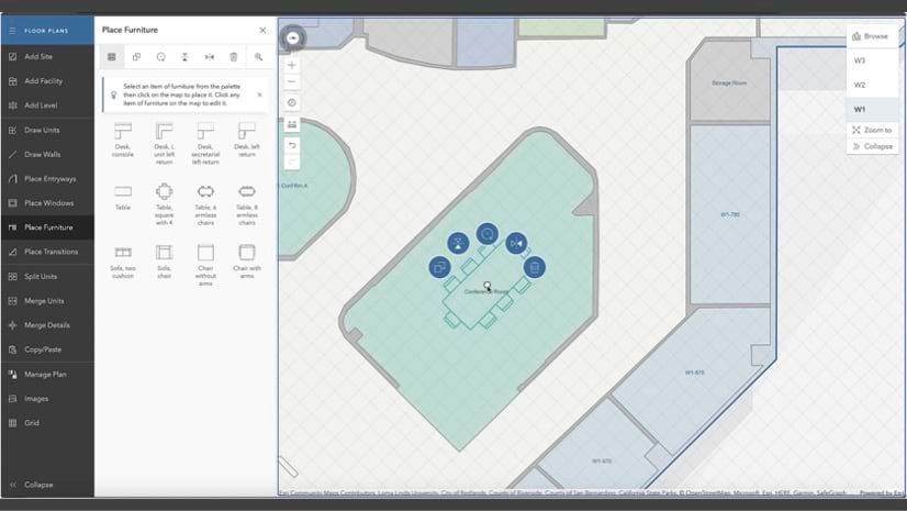
Floor Plan Editor
In November 2023, we released the Floor Plan Editor in ArcGIS Enterprise 11.2. At the June release, it is now also available in ArcGIS Online. This release is important for organizations such as K-12 schools or local government who may not have dedicated IT and GIS teams that can support setting up ArcGIS Enterprise. With Floor Plan Editor being available in ArcGIS Online, organizations can have their staff in departments like facilities and operations get started with simply providing them with a login.
Floor Plan Editor is a simple and intuitive app intended to easily create floor plans and keep them up to date. Staff who are not trained to use software like ArcGIS Pro or AutoCAD can quickly make floor plan updates or try out what-if scenarios.
Read our blog article about Easy Indoor Map Making with Floor Plan Editor and watch a recording of our webinar to learn more.
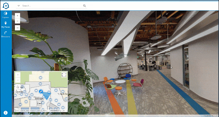
Immersive 360 Degree Photos
Portable and easy-to-use reality capture devices are widely being used today to scan building interiors. These devices are equipped with sensors for LiDAR scanning and cameras that capture 360-degree photos.
A new tool introduced in ArcGIS Pro 3.3 allows these photos to be included in the indoor maps and viewed using the Indoors Viewer web app. These photos provide a more comprehensive view of the indoor space and are very helpful in various situations.
A service technician who needs to complete a work order can better understand the indoor space and its surroundings to make informed decisions before heading to the location. Remote employees who plan to visit the office can better familiarize themselves with the various locations, including reserved office hotels and meeting rooms they plan to visit, before traveling on-site.
ArcGIS Enterprise 11.3 and ArcGIS Online June Update (24R02)
ArcGIS Indoors apps have been updated to include capabilities for managing the hybrid workplace and workspace reservations.
Workspace Areas
Prior to this release, Office Hotels, Meeting Rooms, and Hot Desks were managed separately in the Indoors Space Planner app, and options to manage Meeting Rooms were limited. Separate office hotel and hot desk areas had to be created for the same teams and occupant assignments had to kept in sync manually. The ability to restrict meeting rooms to a group of occupants and enforcing booking limits was also not possible.
This release introduces Workspace Areas, which allow you to manage all your reservable workspaces in one place. This way, you only create the area once and add all types of reservable spaces, assign a reservation manager and occupants, and set scheduling limits to ensure space utilization is as intended. This also eliminates the need to manually sync the occupant assignments across different types of workspaces and reservation managers can now administer bookings for both office hotels and meeting rooms in the assigned workspace areas

Space Planner also includes a new configuration to customize the workspace types you would like to manage in the Workspace Area. For example, if your organization does not utilize Hot Desks the option can be toggled off so it does not appear as an option in the users’ workflows. The same is true even for Office Hotels and Meeting Rooms. This way, users of Space Planner don’t have to worry about workspaces that are not relevant to the organization.

Enhancements to Meeting Room Bookings
With the introduction of Workspace Areas, Meeting Rooms now support the following capabilities:
• Assign Reservation Managers to make bookings for others
• Restrict bookings to selected occupants
• Set scheduling limits like maximum duration or advance booking for individual reservations
Workspace Reservation enhancements
The Indoors Viewer and Indoors Mobile now supports making recurring bookings for meeting rooms as well as an optional setting to enable checking in when using the Indoors Reservations layer.
| Capabilities | Office Hotels | Meeting Rooms |
| Recurring bookings | ||
| – Daily | ✓ | ✓ |
| – Weekly | ✓ | ✓ |
| Reservation Manager | ||
| – Book for others | ✓ | ✓ |
| – Edit, Cancel, Check in for others | ✓ | ✓ |
| Scheduling limits | ||
| – Max bookings per person | ✓ | ✓ |
| – Max duration of booking | ✓ | ✓ |
| – Max days for advance booking | ✓ | ✓ |
Along with new capabilities highlighted above, there are many other enhancements and updates included in Indoor Viewer, Space Planner and Floor Plan Editor. Watch this video for an overview of everything that’s new for Indoors apps in ArcGIS Enterprise 11.3.
ArcGIS Indoors Pro
This release introduces some exciting new functionality available with ArcGIS Pro 3.3, which can be broken down into three main themes:
• Enhancements to CAD and BIM import capabilities
• Initial support for importing 360 images into an Indoors workspace
• Support for space management workflows in ArcGIS Pro
Enhancements to CAD and BIM Import
To better support your needs, we’ve added several enhancements to our tools that enable import of CAD and BIM files into ArcGIS Indoors. These include:
– Import 3D features from IFC. The Import IFC To Indoor Dataset tool, initially released at ArcGIS Pro 3.2 to support loading 2D floorplans from IFC, now also supports importing 3D features.
As with the Import BIM To Indoor Dataset tool, this support includes importing a subset of 3D multipatch features from the IFC model for rich visualization in floor-aware scenes.

– Support for importing linked models from Revit. As Revit models can get large when several teams work on different aspects, such as different parts of a large building, or different disciplines, such as electrical, mechanical, structural, linking multiple Revit models for the same building is a common practice. You can now use the Import BIM To Indoor Dataset tool to import linked Revit models along with the main model to the Indoors workspace.

– The ability to import Roofs as Levels. Some customers have spaces or assets located on the building roof, such as parking spaces, security cameras, etc., that they want to manage in their Indoors workspace. These are often modeled as Roofs in their Revit or IFC files versus Floors or Slabs and could not be incorporated into levels features. Importing Roofs as levels is now possible using the Import BIM To Indoor Dataset and Import IFC To Indoor Dataset tools.
– Support for importing multiple CAD files per level using the Import CAD To Indoor Dataset tool. Customers who store data for a single level across multiple CAD files can now import all of them in a single tool run that combines them in a level in the Indoors model. This will help support customers with scenarios where rooms and annotation are stored in one CAD file and details (individual doors, windows, etc) are stored in a different one, or where each wing of a level is contained in a separate CAD file.
360 Image Support
There are also some exciting new developments in the photo reality realm. Scanning devices, like Leica’s BLK2GO, the NavVis VLX, and others can capture point cloud data and 360-degree photos.
Once you have processed your scans in the reality capture provider’s software, you can export them as .e57 files, a common interchange format, and include the photos in your map.
This release introduces a new tool called Import Indoor Images, that allows you to import photos from .e57 files to an oriented imagery dataset. It populates the Level ID based on the vertical and horizontal overlap of the photos with the levels features in your Indoors workspace. This new tool provides foundational support for the photo reality experience we’re developing for the Indoors web and mobile apps.
Along with the Import Indoor Images tool, we’ve added support for configuring oriented imagery layers as floor-aware. Once you’ve imported your images to an oriented imagery layer using Import Indoor Images, you can explore and visualize those photos using the oriented imagery viewer in Map Viewer on ArcGIS Online and ArcGIS Enterprise.


Support Space Management
Finally, new enhancements support the hybrid workplace and better workspace management.
– The Update Occupant Features tool now supports specifying workspace occupants’ status as “work from home”. This is already supported in Indoors Space Planner, but if you manage this information in your HR system, you can now also use ArcGIS Pro workflows to add and update this information. You can create occupant features with a work from home assignment when you first load data to the Occupants layer, and periodically run it against the HR data to keep the Indoors model up to date with employee changes.

– We also added two new coded value domains to the Indoors model, to support new workspace areas. These domain values are created in new Indoors workspaces by the Create Indoors Database tool, or you can use the Upgrade Indoors Database tool to add them to an existing workspace.
Visit the ArcGIS Indoors product page, sign up for our newsletter and join us on the Esri community to stay up to date on details like early adopter opportunities, events, releases, and other news.


Commenting is not enabled for this article.