The ‘Human Geography’ basemaps have a fan club! A group of users that appreciates the versatility of the monochromatic palette and the three-layer base/reference structure. These basemaps were designed to focus on the needs of the ‘human’ geographer, but, somewhat to my surprise, it seems that their use spreads well beyond that.
So should we do more for those working on physical/environmental maps by building a companion? We have a good selection of basemaps for this already (Topographic, Outdoors, Terrain with Labels, Ocean), but none of them incorporate the flexibility of the Human Geography maps.
With input from my colleagues Emily Meriam and Lisa Berry, I’ve developed prototypes for Light and Dark ‘Physical Geography’ basemaps, based on the ‘Human Geography’ model.
Construction
The structure is the same – a simple base layer and two reference layers, one designed to be used with a high degree of transparency. But there are differences, in content and organization.
The palettes are monochromatic… ish. I’ve used a subtle mix of warm and cool grays to create some separation between water and land features.
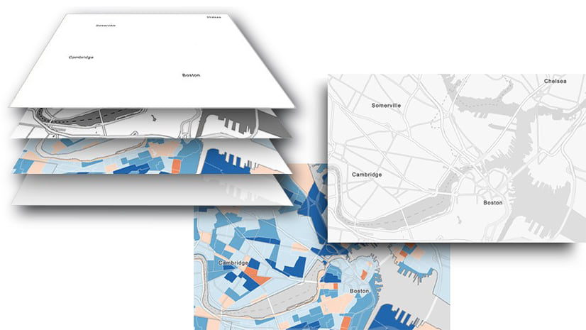
The basemaps are divided into three layers:
The Base Layer:
With land/water polygons.
The Detail Layer:
A reference layer (it sits above the subject matter of the map), it is designed to be used with a transparency setting. The default setting is 50%, but you can adjust it to suit. It includes water features, with bathymetric information in the maritime areas. Roads and transportation are included at larger scales, and buildings at very large scales.
The Reference Layer:
Not called the ‘Label’ layer in this case, because administrative boundaries move here from the Detail layer. This is designed to be used without a transparency setting, and it includes all labels as well as the boundaries. Physical feature names are added, and given prominence over other labels.
Now let’s take a look at the two designs:
Note that some of the settings discussed below will not work in Map Viewer Classic. However, a bit of reorganization and adjustment of transparency settings will resolve the problems if you want to use that.
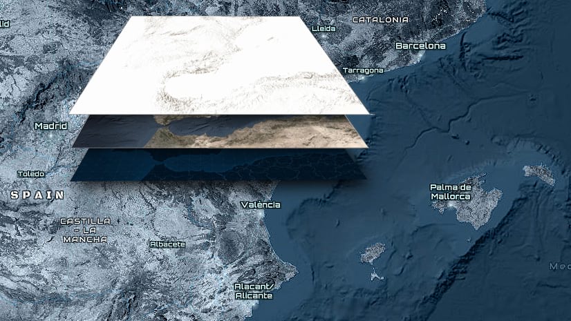
The Light Version

The Base layer includes a land polygon in white. It is there to establish a foundation for the basemap, but it can also be used as a mask if you want to exclude any information from the land.
Use it with…
Anything you like! But the Physical Geography Basemap is designed to work well with the hillshade layers in the Living Atlas (vector and raster).
For the moment, the web map includes some additional layers.
- World Hillshade (set as a reference layer above the Detail, with a ‘multiply’ blend setting).
- As an alternative, the World Hillshade (vector) set as a base layer (it can be a reference layer if you prefer). Although it is not needed in this position, the ‘Multiply’ blend is set, so that it can be combined with…
- … the World Oceans Base. The base layer acts as a mask for the land. The Grayscale Effect is applied, to bring the layer into keeping with the rest of the map, but it can be used without it. Make sure that you have at least one layer below the Oceans Base to stop it limiting the scale range (I’ve added the ‘Blank White’ basemap). If you are a premium user, the ‘Topobathy’ version is available to you at all scales.
Use any combination of these (or any other layers) to form your basemap.
Here are some examples of the basemap in use (The original maps and further details can be found in the ArcGIS Living Atlas).

The Dark Version

The Physical Geography Dark Basemap is is structured slightly differently.
Use it with…
World Hillshade (Dark). ‘Contrast’ and ‘Hue Rotate’ Effects have been added to the hillshade to achieve this look. It works well with this map, but it is tricky to use it as a reference layer (Feel free to try it out though).
The base layer is switched off – Switch it on if you don’t want to use the hillshade.
Here are some examples of the basemap in use (The original maps and further details can be found in the ArcGIS Living Atlas):

Options
While these Physical Geography basemaps are prototypes, I’ve given you some content options. To use them, open the component layers of your preferred basemap into the Vector Tile Style Editor (VTSE), and save your own copies:
- If you would prefer the boundaries to be in the Detail layer, they are available. Use the ‘visible’ toggle in the VTSE to switch the ‘boundaries’ group off in the Reference layer, and on in the Detail layer.
- If you would prefer the bathymetry and other water features to be in the base layer, they are available. Use the ‘visible’ toggle in the VTSE to switch the ‘Water’ group off in the Detail layer, and on in the Base layer.
*****
These basemaps and their layers are creative prototypes, but they are available for you to use with your maps. I’m not planning to take them offline any time soon, but if that concerns you, make copies to your own account via the Vector Tile Style Editor. The content will continue to update on a regular basis, but any future style changes I make will not carry over. Of course, you are free to make adjustments to your own copy, or use it as a starting point for anything else you may want to do.

Article Discussion: