A lot has changed since 1992…
Gasoline was a buck o’five…Johnny said “Goodnight”…Clinton defeated Bush…and Whitney proclaimed “I will always love you.”
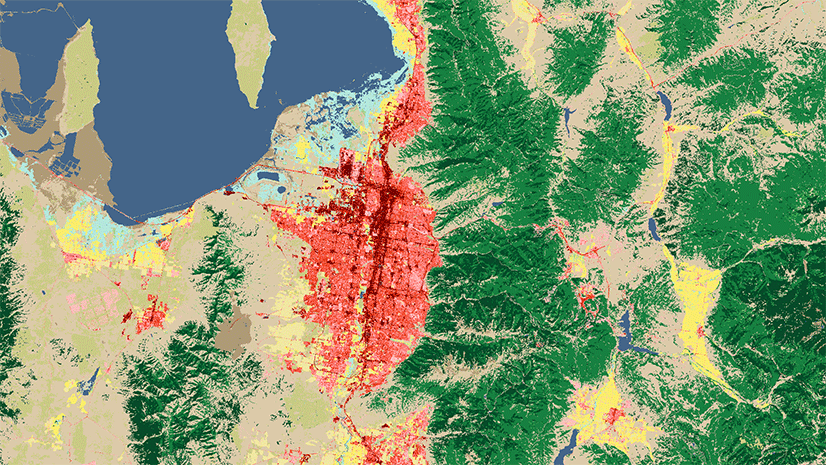
A lot has changed on the land surface of Earth as well, but those details may not be as ingrained in our memories. Fortunately, they have been observed by a series of satellites and spatiotemporally harmonized by the European Space Agency from 1992 – 2018. The 300-meter per pixel resolution of the ESA CCI land cover maps provide a detailed look at the last three decades of changes such as deforestation, urbanization, desertification, and even conservation.
That time series is now available in ArcGIS Living Atlas of the World. Each year is an analytical raster, allowing you to discover both stark and subtle changes over time.

In this set of images, we see the conversion of forest land to agriculture that the southern region of the Brazilian Amazon has undergone, mostly in the 1990s and early 2000s.
Cartographers Emily Meriam and Michael Dangermond created a custom color palette for these land classifications that uses intuitive colors but also highlights land conversion, helping to visually reinforce humankind’s modification of natural habitats.
Multiple Ways to Map

In addition to the 36 standard CCI land cover classes, several other templates are available in this layer that help to simplify common mapping workflows, including Forested Lands, Urban Lands, and Converted Lands. To apply these in ArcGIS Online, select the Image Display options on the layer. Then pull down the list of variables from the Renderer options. Click Apply and Close. In ArcGIS Pro, go into the Layer Properties. Select Processing Templates from the left-hand menu. From the Processing Template pull down menu, select the version to display.
Additional Land Cover Maps
Besides the new ESA Land Cover, there are several other resources in Living Atlas that might help jump start your mapping and analysis needs.
- World Terrestrial Ecosystems: a newly released layer that uses land cover as input to generate 431 unique terrestrial ecosystems on Earth.
- USA National Land Cover Database: a higher resolution (30-m) time series, but not available for as many years as ESA.
- MDA BaseVue 2013: a 30-m global land cover map available for 2013.
Feel free to ask questions or comment below, or visit our GeoNet.


Article Discussion: