The Esri User Conference returns to San Diego in one month! To help you navigate the hundreds of sessions and activities being offered, we have prepared an agenda for ArcGIS Experience Builder. Session times are provided in Pacific Daylight Time.
For a full list of sessions and activities and to create your schedule, view the detailed agenda.


Monday, July 10
8:30am – 3:30pm
Esri President Jack Dangermond and guests
Jack Dangermond and thought leaders will share how GIS is being used to uncover new insights to create a more connected, sustainable, and equitable world. Esri experts will demonstrate advancements in ArcGIS. Discover the latest technology and see innovative work from our global community.

Tuesday, July 11th
Managing maritime ports with ArcGIS
10:00am – 10:45am
Kyle Crawford, Esri
Maritime ports serve as a pivotal part of a region’s economy and security as organizations balance the never-ending movement of people and goods. Come learn how GIS can improve the management of infrastructure and operations to handle the ever-growing demand.
Applying GIS in public transit investment and construction projects
10:00am – 11:00am
Aurelia Setton, Exodigo
Bill Farquhar, RailPros
Thomas Brown, HDR
The need for effective public transit has significantly increased. However, with it being a unique time of more federal funding available to invest in our public transit, ensuring our routes stay moving while new ehancements are being made are a must. Join us to learn the best practices on how GIS can improve the project delivery cycle.
ArcGIS Experience Builder: Getting started with developer edition
1:00pm – 2:00pm
Jianxia Song, Wei Ying, and Gavin Rehkemper, Esri
ArcGIS Experience Builder enables you to quickly build web apps and web pages with no-to-low code. It is highly configurable with flexible design, mobile optimization, smart widgets, and integration. It is extensible so you can add your own tools to deliver production ready solutions fast. Come to learn everything about the developer edition, from installation, collaboration, and deployment, to upgrading, including importing apps from ArcGIS Online, adding custom widgets to ArcGIS Enterprise, and more.
Managing invasive species with GIS
1:00pm – 2:00pm
Chelsey Buffington, Washington Department of Fish and Wildlife
Yan Li, Orange County Public Works
Join this session to explore how organizations are leveraging ArcGIS and remote sensing to more efficiently detect and record invasive species and attempts at removing them, saving time, and lessening the difficulty of this often-dangerous work.
Paving the path to a brighter tribal health and safety future
1:00pm – 2:00pm
Nizah Fino, FEMA
Domonique deBeaubien, Seminole Tribe of Florida
Unlock the power of technology to tackle health and safety challenges facing tribal communities. Discover how utilizing spatial data and advanced geographic information systems can streamline workflows and help plan for and prevent unexpected events.
Understanding the value of a comprehensive asset management program
1:00pm – 2:00pm
John Thomas, District of Columbia Department of Transportation
Joshua Argento, Jason Cowart, and Victoria Guerra, Harris County Toll Road Authority
By understanding the value behind where your assets are is key to prolonging the asset life’s which will in turn save money and time in the future. These presentations by two departments of transportation highlight how they have implemented GIS to support an asset management program.
ArcGIS Experience Builder: An introduction
2:30pm – 3:30pm
Jianxia Song and Alix Vezina, Esri
ArcGIS Experience Builder empowers you to quickly transform your data to interactive, mobile optimized web apps and web pages. It provides a new level of configuration with flexible design, mobile optimization, smart widgets, and integration. Learn the building blocks of Experience Builder including pages, windows, widgets, data sources, layouts, and themes, as well as how they work together, then adapt the content on different screen sizes, integrate with ArcGIS Survey123 and ArcGIS Dashboards apps to streamline processes, and interact with your 2D and 3D data for immersive experience.
Getting started with user types
2:30pm – 3:30pm
Marley Geddes and Scott Sandusky, Esri
ArcGIS is accessed by people with different needs. Not everyone requires access to the same capabilities and apps, including web service, ArcGIS Pro, configurable apps, and more. With user types you can manage it all! They provide an ArcGIS identity, but also align with an individual’s need for GIS functionality. This session will review the different user type options, guide you through selecting the correct user type for your staff, and demonstrate how to administer them.
ArcGIS Experience Builder: Building your first widget
4:00pm – 4:45pm
Alix Vezina and Previn Wong, Esri
Learn how to use TypeScript and React to build your first widget in ArcGIS Experience Builder developer edition. We will also show you how to debug your widget and improve your debugging experience.

Wednesday, July 12th
Urban context and planning
8:30am – 9:30am
Kim Voros, Alta Planning & Design
Ric Reynolds, Geotechnical Consultants Inc.
Learn how Experience Builder allows users to explore key plan content like interactive maps. Learn how to use GIS to overlay socioeconomic data and discover impacts.
Web editing: What’s new and the road ahead
8:30am – 9:30am
Jeremy Bartley, Larry Young, and Scott Sandusky, Esri
Significant advancements have been made to the data editing capabilities available through the ArcGIS API for JavaScript. Many of these new web editing features are supported in ArcGIS client applications, with goals of a consistent experience and license model. Learn about the ArcGIS web editing strategy, what’s available now, and what’s to come. You’ll even get a sneak peek of a new focused Web Editor application for data maintenance and enabling self-service data editing throughout an organization.
ArcGIS Experience Builder: Tips and tricks
11:30am – 12:15pm
Jianxia Song, Wei Ying, and Thomas Coughlin, Esri
In this session we will provide tips and tricks to expose the hidden gems of ArcGIS Experience Builder. Learn how to do things like copy widgets from one page to another page, display a message or an image when there is no selected feature, filter multiple layers at once, work with layer visibility so you can use one web map for multiple maps, and more!
ArcGIS Experience Builder: An introduction
2:30pm – 3:30pm
Jianxia Song and Alix Vezina, Esri
ArcGIS Experience Builder empowers you to quickly transform your data to interactive, mobile optimized web apps and web pages. It provides a new level of configuration with flexible design, mobile optimization, smart widgets, and integration. Learn the building blocks of Experience Builder including pages, windows, widgets, data sources, layouts, and themes, as well as how they work together, then adapt the content on different screen sizes, integrate with ArcGIS Survey123 and ArcGIS Dashboards apps to streamline processes, and interact with your 2D and 3D data for immersive experience.
Improved situational awareness for public safety
2:30pm – 3:15pm
Jeff Baranyi, Esri
One of the key benefits for the use of GIS in Public Safety is for situational awareness. In this session we will discuss how Esri technology advancements help improve situational awareness. Specifically we will cover how Experience Builder is evolving to better support public safety needs, trends in configuring ArcGIS Dashboards, and patterns for automation of key situational awareness workflows.
Working with oriented imagery
2:30pm – 3:15pm
Cody Benkelman, Athul Krishnan, and Emily Windahl, Esri
Oriented imagery, now fully integrated into the ArcGIS system, is a capability for managing, visualizing, and exploring images. Image types include high oblique, street-side, close-range inspection, 360-degree, and panoramic images, and video. This session will demonstrate managing your imagery as an oriented imagery catalog, publishing catalogs to ArcGIS Online and Enterprise, and using your imagery in ArcGIS Pro and apps built with ArcGIS Experience Builder, where end users can efficiently access your imagery via the web in the context of a 2D web map or 3D scene.
ArcGIS Experience Builder: Migrating from ArcGIS Web AppBuilder
4:00pm – 5:00pm
Jianxia Song and Alix Vezina, Esri
ArcGIS Experience Builder is built on the latest web technologies. As more capabilities are added to Experience Builder, it’s time to consider modernizing your ArcGIS Web AppBuilder apps. In this session, you will learn how to improve your app with the most modern technology Experience Builder offers while keeping a consistent user interface and workflow to minimize the impact on your existing audience. We will talk about Experience Builder templates, building complete experiences and mobile optimization.
Imagery: Creating an app for exploring oriented imagery
4:00pm – 4:45pm
Athul Krishnan and Emily Windahl, Esri
Oriented imagery is an ArcGIS-wide solution for managing, visualizing, and exploring images that don’t fit into a typical mapping context—including high oblique, street-side, close-range inspection, 360-degree, and panoramic images, and even video. This demo theater session will review your options for working with oriented image catalogs (OICs) via the web. For organizations seeking a more customized interface, the presentation will also show how to create a unique app using ArcGIS Experience Builder, where end users can view and explore your imagery in a web map or scene.
Thursday, July 13th
Mitigating natural hazards for community resilience with GIS
Thursday, July 13th, 8:30am – 9:30am PDT
Fahad Alahmadi, PhD, Ministry of Environment, Water and Agriculture of Saudi Arabia
Explore how GIS modeling, including digital twins, is enabling communities to develop improved resiliency. ArcGIS Pro Suitability Modeler is being used to identify the optimum sites for rainwater harvesting activities for arid regions. A collaborative digital twin is enabling one community to better respond to the impacts from climate change, including flood analysis and coastal management.
Using dashboards for data sharing
8:30am – 9:30am
Juliana Spector, California Department of Water Resources
Joe Farah and Nizar Salih, City of Renton, Washington
Discover how water resource managers are using ArcGIS Online and ArcGIS Dashboards to display and share data in new and exciting ways. Portals, dashboards, web apps and more are being used to visulaize and interact with data like never before. Join this session to hear how your peers are implementing solutions that help them to track projects, gather and share information, create unique user experiences, and work more efficiently.
ArcGIS Online: Accessibility best practices
10:00am – 10:45am
Ross Donihue, Jessica McCall, and Tonghui Ming, Esri
ArcGIS Online offers many useful accessibility features and provides functionality within the application to allow users to generate accessible content for all audiences. This demonstration will highlight new and existing accessibility features found in ArcGIS Online.
Optimize analysis for climate change applications
10:00am – 11:00am
Hubertus Kraus, IPM Ingenieurbüro Peter Müller GmbH
Teresa Gomez and Chad Hyer, Brigham Young University
Learn how GIS tools optimize site suitability analysis to reduce climate change impacts.
Safety and security with GIS
10:00am – 11:00am
Lucas Hershberger, LJB Inc.
Nancy LaFarge, HNTB
In this session you’ll learn how safety managers plan, prioritize, and improve safety throughout their organizations by visualizing risk data. Don’t miss this opportunity to learn how ArcGIS technology was implemented to facilitate interactions, communications, security, and management of the building’s assets between all members of the community.
ArcGIS Experience Builder: Explore apps built with Experience Builder
11:30am – 12:15pm
Thomas Coughlin and Eva Moyer, Esri
In this session you’ll see staff picks of the best user-created Experience Builder apps. We’ll go over features and design choices that are worth considering for your web apps.
A GIS framework for resilience planning
1:00pm – 2:00pm
Imrul Hack, Broward County, Florida
Ivan Melchor, Princeton University
Planners play an essential role in supporting the resilience planning strategies for their communities. Using GIS ensures key stakeholders are aligned, promote smarter decision-making, and enable sustainable solutions. Learn how enhancing your approach with GIS can improve public feedback, analyze collected data, and visualize plans for the future.
ArcGIS Experience Builder: Working with style and layout
1:00pm – 2:00pm
Tonghui Ming and Wei Ying, Esri
With ArcGIS Experience Builder, you can create the exact web experiences you want with scrolling or full screens, and single or multiple pages. Understand what the style settings do like auto vs custom and how they change depending on the page layout could be challenging sometimes. Come to learn all about using styles and layout widgets to design your web experiences that are optimized on Mobile.
Efficient nonprofit solutions to share high priority community needs
2:30pm – 3:30pm
Spencer Cox, Cincinnati Center City Development Corp (3CDC)
Often, nonprofits are presented with the challenge of informing the public about high priority needs in a community. But what is the best way to engage the public efficiently? Come explore how GIS positively transformed the way nonprofits have tracked, analyzed, and publicly shared data insights for high priority community concerns.
Friday, July 14th
Web editing: What’s new and the road ahead
9:00am – 10:00am
Jeremy Bartley, Larry Young, and Scott Sandusky, Esri
Significant advancements have been made to the data editing capabilities available through the ArcGIS API for JavaScript. Many of these new web editing features are supported in ArcGIS client applications, with goals of a consistent experience and license model. Learn about the ArcGIS web editing strategy, what’s available now, and what’s to come. You’ll even get a sneak peek of a new focused Web Editor application for data maintenance and enabling self-service data editing throughout an organization.
Plan your experience
Whether you’re heading to San Diego or following along via live stream or recording, it’s never been easier to create your schedule. View the detailed agenda to get started.
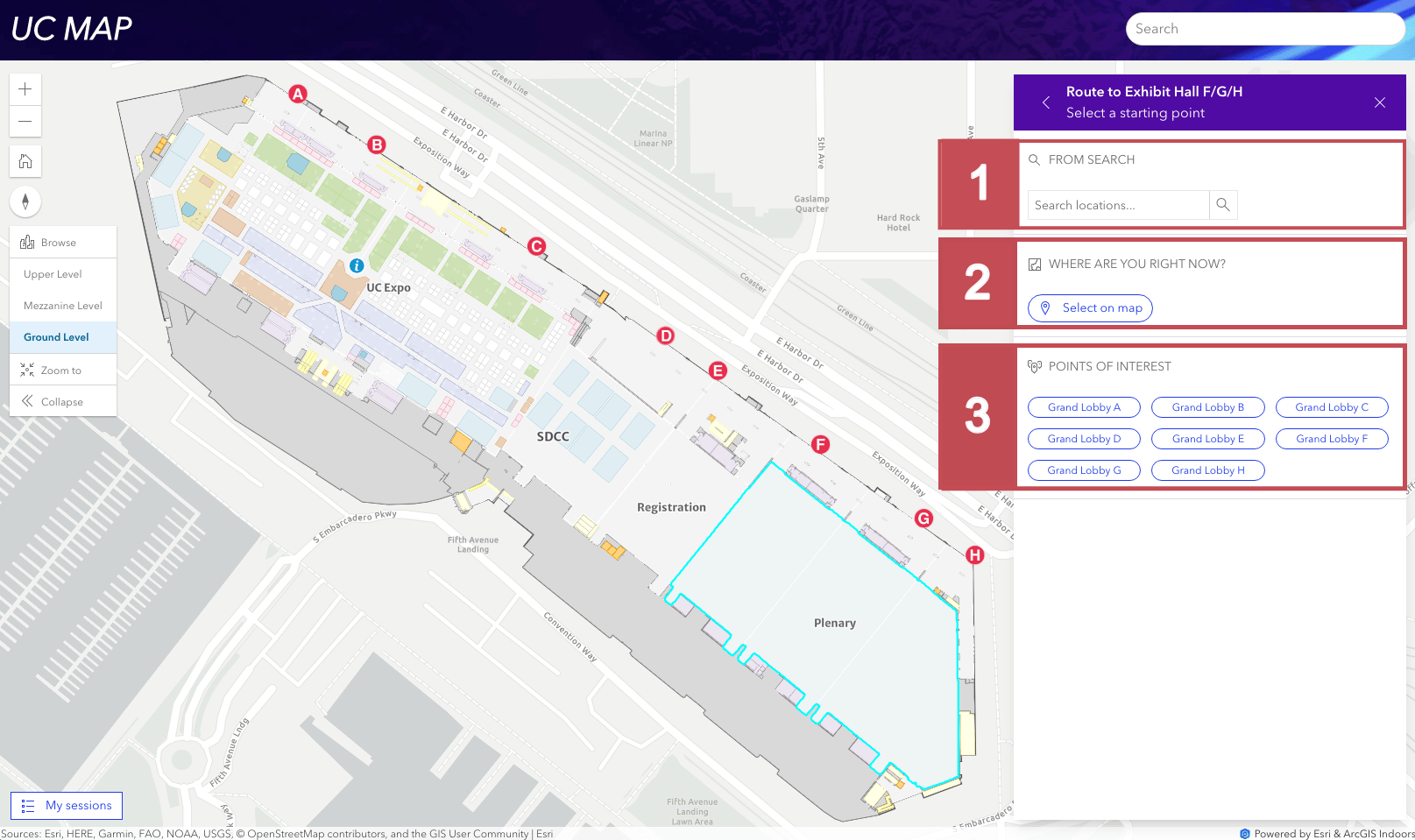
New this year is the UC Event Map.
Haven’t registered for the conference? It’s not too late. Join the in-person event, register for digital access, or watch the Plenary Session only.
Register Now

Add us to your map
Connect with the Experience Builder team at the Esri UC Expo.
Stop by the Apps Area on Tuesday and Wednesday from 9:00am to 6:00pm and Thursday from 9:00am to 4:00pm. Share your ideas and product wish list with us. Provide feedback and ask questions.
Looking for more ways to connect? Attend the ArcGIS Experience Builder session at the Education Summit @ Esri UC. Swing by the Map Gallery reception on Monday evening. Follow @ArcGISApps on Twitter with #EsriUC2023 to get updates in real-time.
We’ll see you all soon!


Article Discussion: