When you think of swiftly growing cities across the US, most often the first that come to mind are places like Seattle and Denver, cities that are already sizable. While it is true that these are some of the fastest growing cities in the country; in South Carolina, the fastest growing city has an estimated population of just over 6,500.
This city is Hardeeville, which has experienced nearly 120 percent growth since 2010. This growth is due to a few key factors including major development interest and investment. As a result, Hardeeville has annexed land surrounding the city, growing from 5 square miles to approximately 50 square miles.
With large swaths of prime undeveloped land in Hardeeville, multiple large-scale developments have been proposed.
Striving for Cohesive, Sustainable Development
The city welcomes new development, but also recognizes the challenges that it brings. New planned developments like the East Argent Community involve bringing 9,500 new residential units and 1.5 million square feet of commercial space to 7,351 acres of land in northeast Hardeeville.
According to Hardeeville City Planner, Kiel Jenkins, “One of the primary challenges Hardeeville faces is working with developers, neighboring jurisdictions, and staff to ensure that these large tracts of land are developed sustainably and maintain connection with surrounding and previously existing development, as well as protecting wetlands and maintaining a semblance of its rural character.”
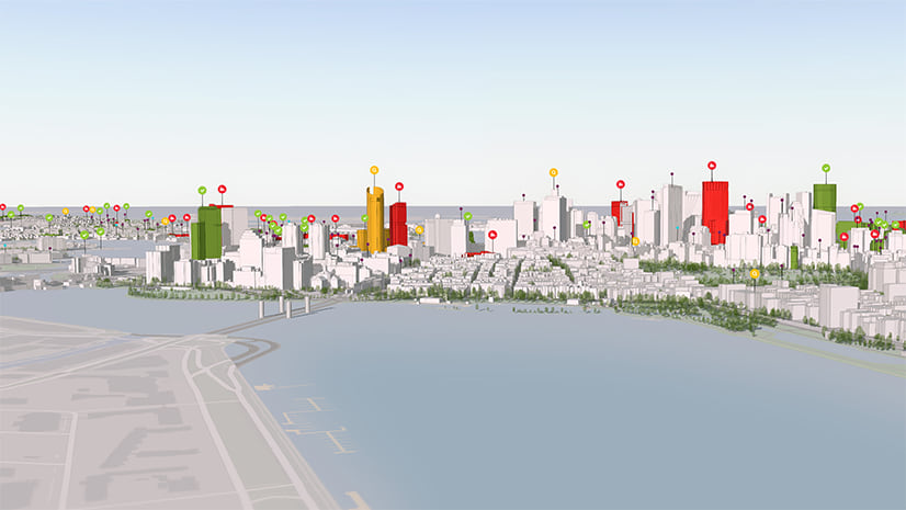
ArcGIS Urban enables Hardeeville planners to make data driven decisions, keeping sustainability in the conversation during planning efforts.
Many small cities across the state and across the country are facing similar challenges. They are often under-prepared for the waves of new development interest for both greenfield and infill development.
Hardeeville planners, seeking a tool that allows the visualization and review of new proposed development in context with existing development in the city, engaged with Esri’s Smart Cities team to pilot ArcGIS Urban.
Modeling Development Impact and Zoning Capacity
The Hardeeville Department of Planning is using the 3D visualization tools in ArcGIS Urban to develop and test master plans for major areas of redevelopment and new development projects in the city.
As Hardeeville develops master plans for these areas likely for new development, “the ability to model zoning changes and overlays will be crucial,” Jenkins says. “The ability to visualize these changes and the impacts they may have on job creation, population growth, and housing will influence future decisions with regard to new roads and infrastructure.”
Currently, the city does not employ a full time GIS position, so having a GIS-enabled product designed to be user friendly for planners has made it accessible to Hardeeville.
Efficiency in the Planning Process
Hardeeville planners are excited to have the ability to model scenarios for master plans within new and existing planned development districts (PDDs).
Many of the PDDs are primarily undeveloped and the ability to model potential layouts for master plans is extremely valuable throughout the planning process.
“One of the difficulties in working with large undeveloped tracts of land is the difficulty in visualizing what development could look like in the future,” Kiel said.
Being able to swiftly create different zoning and development scenarios to test their maximum potential and capacity is crucial. This allows planners to ensure that these areas develop in sync with the vision for the community.
According to Jenkins, “having zoning codes and use tables programmed into Urban will remove a majority of the need to dig through the MZDO (Municipal Zoning & Development Ordinance) to find setback requirements, use allowances, and density restrictions.”
Further, Hardeeville staff are looking to improve the Staff Review Committee process, the process by which Hardeeville planners review projects. Site plans often go through many stages of revisions.
“On a day to day basis, ArcGIS Urban will allow site plans for individual development projects … to be modeled.”
“The ability to show the changes in site plans over the Staff Review Committee process will show the review process and the work that goes into site review,” says Jenkins.
Enabling Transparency in the Planning Process
In Hardeeville, as with many cities across the country, the ability to visualize the planning process and proposed developments in context is critical, both for internal workflows and for communication with stakeholders.
“I anticipate ArcGIS Urban helping us with providing a visual model of the planning process to staff, planning commission, city council, and members of the public, which will help Hardeeville make the best decisions when planning for the future,” says Jenkins. “Ideally, this will remove … confusion regarding what a development will look like, what a certain density looks like, [and] other details that at this time can only be represented in 2D or tabularly.”
If you are interested in learning more about ArcGIS Urban, schedule a demo here: http://go.esri.com/Urban-Demo.


Commenting is not enabled for this article.