ArcGIS Indoors helps intelligent airports connect interior spaces, assets, operations, and the passenger experience
Inside busy terminals where passengers, employees, tenants, assets, and revenue generating activity converge, finding the authoritative answer to a simple question – “Where is it?” can be surprisingly difficult.
Interior information is often distributed across CAD drawings, building information models, spreadsheets, lease systems, work order platforms, paper records, and institutional knowledge. Different teams often maintain different versions of the same floor plan. Concession spaces move, offices are reassigned, and terminal renovations continually alter the physical environment. The result is fragmented information, duplicated effort, and uncertainty.
This is more than a data management inconvenience. Outdated and disconnected information impedes maintenance, slows inspections, undermines lease tracking, increases costs, creates gaps in safety and security, and impacts customer service. All is not lost, however. There is a better way – Geographic Information Systems (GIS) and ArcGIS Indoors provide a path to bring that information together into a single source of truth, unified with floor aware maps that serve as the foundation for a living digital twin of the terminal. But what exactly is a digital twin?
From Disconnected Drawings to a Shared Source of Truth
An indoor digital twin is not simply a 2D or 3D representation of a building. It is a structured, location-based reflection of facilities, levels, rooms, corridors, doors, furnishings, and other details that matter to indoors workflows. It can represent a twin of passenger activity, maintenance history, phases of construction, and even energy consumption. But the primase for any digital twin is that it accurately reflects a reality and that it is maintained as the foundational source of truth.
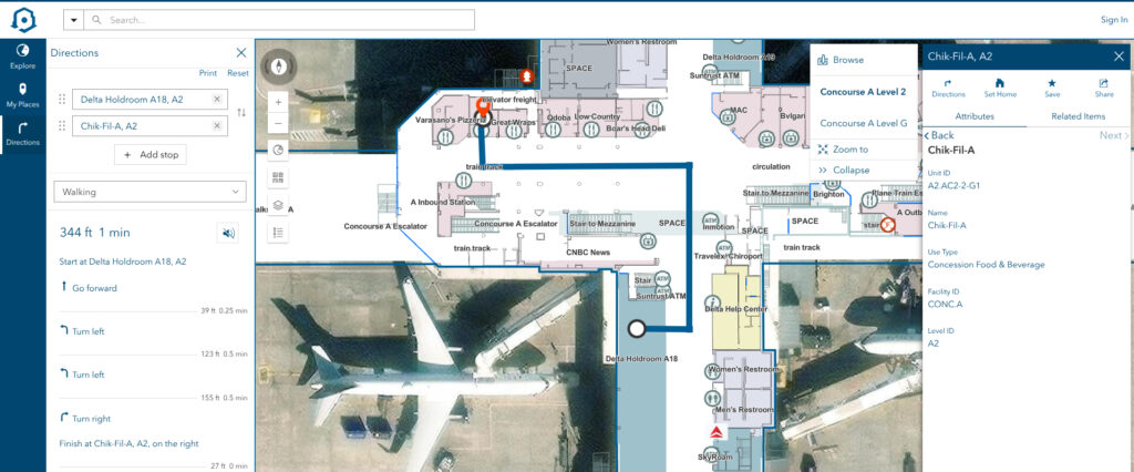
ArcGIS Indoors connects the physical spaces in terminals to authoritative business information about them, giving staff a common geographic framework for understanding what exists, where it is located, how it is used, and what is changing. Its Indoors Information Model (IIM) organizes the terminal into core elements: facilities, levels, units, and details. Facilities represent building footprints. Levels establish floor order and allow users to filter and see one floor at a time. Units define spaces such as offices, hold rooms, concessions, restrooms, corridors, and storage areas. Details include cubicles, columns, doors, furniture, fixtures, and other physical assets, adding context that make map understandable and operationally useful.
That structure transforms static floorplans into information users can search, analyze, maintain, and consume with GIS applications. The IIM creates a living foundational reference for integrating lease records, work orders, inspections, asset inventories, and other enterprise systems. Instead of becoming another isolated application, indoor GIS becomes the spatial entry point to an intelligent airport’s broader operational ecosystem.
Converting Complex Source Data into Useful Information
Building this foundation requires more than importing drawing files, laser scans, and Building Information Models (BIM). These file types are often large and complex, containing far more detail than every user needs. A public facing map, for example, should not expose the same information as an internal operations application. Likewise, a facilities team may need detailed assets and information within restricted areas that would add clutter or be unpermitted to a passenger wayfinding experience.
Developing an indoor digital twin requires a commitment and a mix of resources: time, skilled technicians, software, hardware, and data that few airports maintain in-house. As a result, self-guided deployments are uncommon. Most airports use a “team of teams” that brings internal staff and decision-makers together with Esri and specialty partners trained and certified to support implementation.
LandTech Consultants, a trusted Esri partner with an ArcGIS Indoors specialty, helps airports assess source data, identify priority use cases, and convert desperate data and drawings into a consistent indoor model. Their team reviews layers, removes unnecessary content, standardizes spaces, adds relevant attributes, and checks that each feature is assigned to the correct facility and level. The goal is not to preserve every line in a master drawing. Rather, it is to create an efficient, usable representation tailored to the airport’s business needs.
Following a repeatable practice they have refined over time, LandTech undertakes a discovery process that is collaborative and iterative. As airport stakeholders see their information in a floor-aware environment, they often recognize new opportunities and use-cases. Often initial requirements to map spaces expand to include employee space planning, lease management, work order integration and maintenance routing, emergency assets, and wayfinding. Starting with clear goals and outcomes helps prioritize what to map and model first – setting a foundation that inevitably expands with users and business cases.
One Foundation, Many Airport Workflows
Once interior spaces are mapped and units are tagged with unique identifiers “addresses”, they are connected to the workflows that sustain better terminal operations:
- Space and workplace management: Staff can visualize office assignments, meeting rooms, shared areas, and available space across multiple floors.
- Concessions and lease management: Real Estate and Property teams connect mapped spaces to tenant records, square footage, lease terms, exhibits, and revenue information.
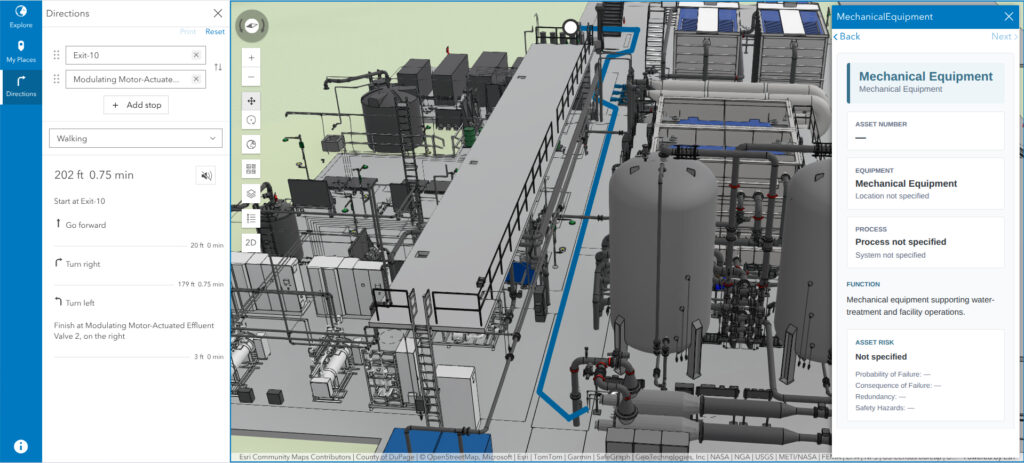
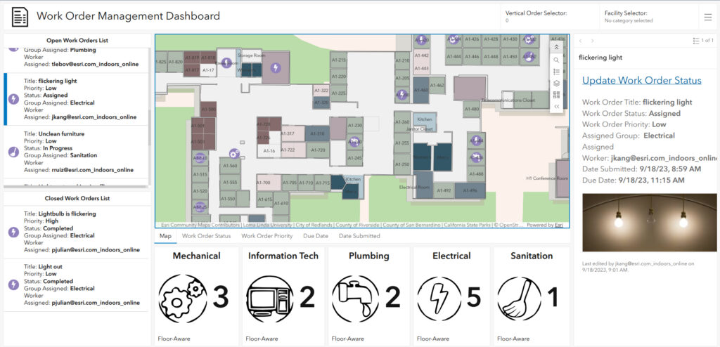
- Maintenance and inspections: Technicians locate a failed asset, navigate to it, review related information, and more efficiently update work from the field.
- Safety and security: Indoor maps can represent restricted areas, emergency equipment, inspection locations, be seen with CCTVs, and track movement through security checkpoints.
- Passenger and employee wayfinding: Floor aware routes account for conveyances – stairs, elevators, escalators, moving walkways, security restrictions, and physical obstacles that change how people move throughout the terminals.
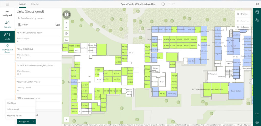
The value increases as these workflows connect. A property manager looking at a concession can access sales and lease information. A maintenance technician can locate an asset in need of repair and receive an appropriate route. An operations team can display floor plan changes in a dashboard. A passenger can find a gate, route to a restroom or concession, without seeing the full complexity behind the map.
Accuracy Is an Ongoing Practice
A digital twin creates value when it reflects reality. Airport terminals are dynamic: construction changes walls, tenants relocate, spaces are reconfigured, conveyances undergo maintenance, and assets are replaced. Maintaining the indoor model therefore requires a documented process for receiving updated drawings, reviewing changes, validating information, and publishing revisions.
Data maintenance and governance is as important as the initial conversion. Airports need clear ownership, coordination points, and update cycles so their Indoor GIS remains authoritative. A qualified partner can help establish and repeat that process, reducing the burden on airport teams that may not have time or dedicated GIS resources.
Implementation and update times depend on the condition of source data, the size and complexity of the facility, and the applications airports require. Clean, well-structured data can accelerate delivery, while inconsistent drawings require more preparation. Either way, governance and a phased approach allow airports to begin with high value operational needs and efficiently add capabilities over time.
Bringing Location Intelligence Indoors
The most effective journey begins with a focused question: Which goals and outcome matter most? Whether the priority is managing space, protecting revenue, maintaining assets, improving safety, or helping people navigate, a trusted indoor data foundation makes each goal attainable. With ArcGIS Indoors and experienced partners, airports can bring their terminals and other interior spaces into their Enterprise GIS and turn “where” into knowledge they can act on.
ArcGIS Indoors brings the power of location indoors. By transforming scattered plans, data, and records into a unified source of truth, intelligent airports gain more than smart floor plans. They have a shared source of truth that supports daily work, connects business systems, improves visibility, and provides a foundation for resilience, sustainability, growth, and innovation.
“Aviate, navigate, communicate”