Introduction
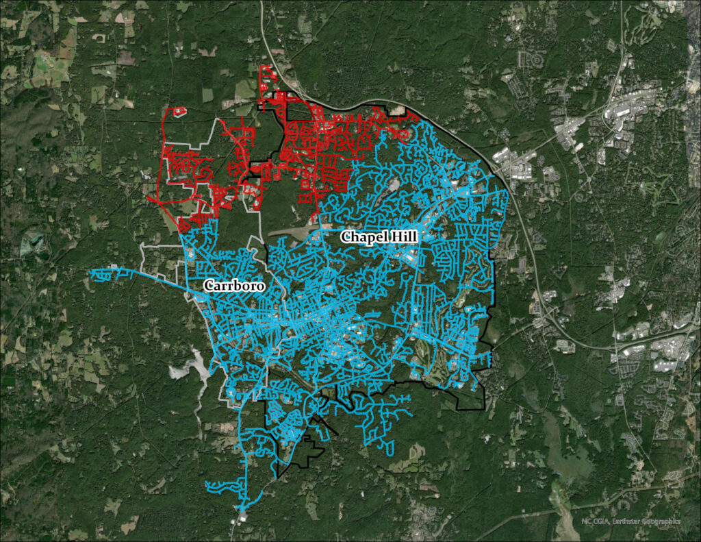
Orange Water and Sewer Authority (OWASA) provides potable water and wastewater services to Chapel Hill, Carrboro, and parts of southern Orange County, North Carolina, as well as reclaimed water services for the University of North Carolina at Chapel Hill (UNC-Chapel Hill) and UNC Health in Chapel Hill. OWASA provides service to approximately 86,500 residents through nearly 22,000 customer accounts. OWASA is responsible for 388 miles of waterlines, 5 miles of reclaimed mains, and 338 miles of sewer lines over 35 square miles. The OWASA geographic information system (GIS) assets also include 6 drinking water storage tanks, 4 water booster pumping stations, 21 wastewater pumping stations, over 2,400 fire hydrants, 13,700 valves, and 11,100 manholes.
As the county’s largest utility, OWASA serves a community that depends on reliable infrastructure and efficient operations. From asset management in Cityworks to billing and Customer Information System (CIS) with SpryPoint, OWASA’s GIS touches nearly every part of the organization. OWASA faced the challenge of migrating to Esri’s ArcGIS Utility Network while maintaining these essential integrations and ensuring continuity for staff and customers. To bring technical experts onboard, OWASA released an RFP for a UN Readiness and Planning project in 2022, for which Timmons Group was selected. Through architecture assessments, workflow reviews, and a comprehensive migration plan, the team guided OWASA through the process of utility network planning and implementation.
“Our utility network migration was a great success after careful planning and extensive testing. Timmons Group are great partners in leading this effort to modernize our GIS data and in preserving our integrations with Cityworks, CIS, CCTV, valve inspections and other systems. OWASA staff in the field and office have easy-to-use web apps and field maps to access the information they need to perform their jobs more efficiently.” —Beth Canada, GISP, GIS Coordinator, OWASA
The Challenge
OWASA’s GIS environment served the utility well for many years, but with the deprecation of ArcMap and the geometric network, OWASA leaders knew they needed a clear path forward. Migrating to Esri’s ArcGIS Utility Network was essential, yet the transition carried risks because of the many systems and processes already tied into GIS.
The biggest challenge was OWASA’s extensive network of integrations. GIS supported asset management through Trimble’s Cityworks, billing and CIS with SpryPoint, inspection systems like Wachs for valve turning and WinCan for sewer CCTV inspections, and utility locating through 811, which integrated via Python scripts that created Cityworks service requests. In addition, the environment relied on a mix of custom Python scripts, SQL views and procedures, and numerous web maps and applications.
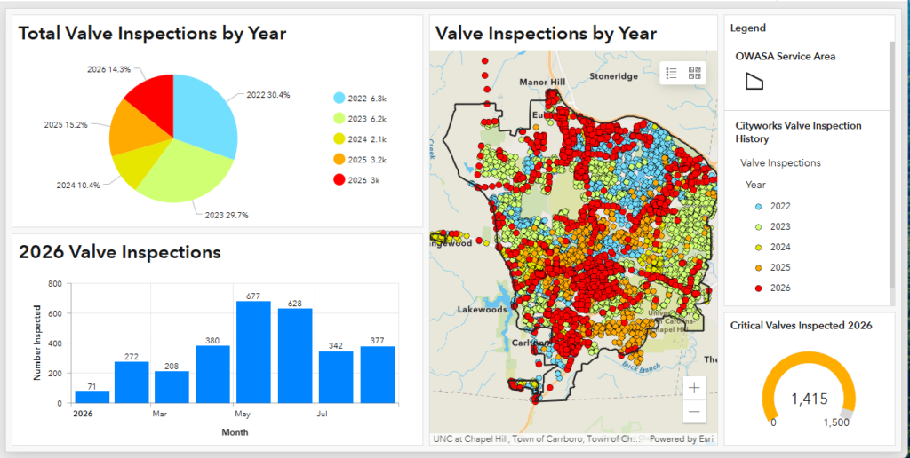
OWASA also had to maintain its high standards for data accuracy and reliability while preparing its editors and IT staff for a completely new platform. This includes a goal of survey-grade accuracy for new development and 100 percent populated and accurate information for critical attributes like size, material, and year installed. For a utility that manages critical water, sewer, and reclaimed water infrastructure in a growing service area, the stakes were high.
Partner Involvement
Timmons Group supported OWASA throughout its transition from the geometric network to Esri’s ArcGIS Utility Network. Working closely with OWASA staff, Timmons Group developed the migration plan, updated the supporting IT architecture, designed the utility network data model, and helped transition existing editing and operational workflows.
During implementation, OWASA experienced the unexpected departure of its Cityworks administrator. Timmons Group helped maintain project continuity by reconfiguring Cityworks to align with the new GIS environment and supporting the integration between the two systems.
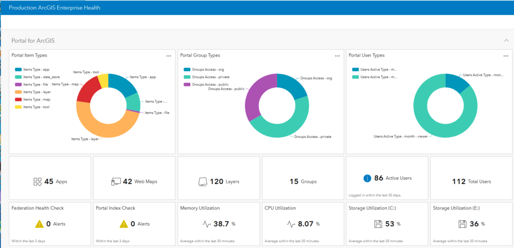
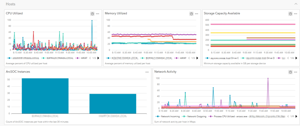
Timmons Group also worked with OWASA to deploy ArcGIS Monitor and establish monitoring capabilities for the new environment. This included configuration, staff training, and tools to help OWASA better understand system performance and reliability.
Following implementation, Timmons Group continued to support OWASA with targeted refinements, including Python-based automation, dashboards, and utility network trace configurations. These efforts helped OWASA transition the new environment into day-to-day operations and provided its staff with the tools and knowledge needed to manage and extend the system over time.
The Results
The Utility Network (UN) Migration Plan provided confidence that the system had been reviewed and that each workflow and integration had been considered before migration activities began. This plan reviewed the ArcGIS Enterprise and GIS architecture, current GIS workflows, existing pain points, and how all those aspects would be addressed or impacted by UN implementation. Doing the data assessment up-front with the plan gave OWASA’s editors plenty of time to correct the data while the rest of the UN migration was underway.
The geometric network data was migrated to three utility networks, without loss of features or data. As a Trimble partner, Timmons Group was able to swiftly pivot when OWASA experienced staff turnover and took ownership of the Cityworks reconfiguration so that it continues working with the GIS data.
One key to long-term success was training OWASA staff to own the solution rather than having to rely on vendors. OWASA GIS editors were trained on ArcGIS Pro as well as how to edit the utility network and what changes were needed for legacy workflows to take into account ArcGIS Pro and the utility networks. Finally, the OWASA GIS administrator received training on how to maintain the new solution by adding new asset types, modifying connectivity rules, and editing attribute rules.
The UN gives additional functionality to desktop, web, and mobile users while also resulting in a higher level of data quality. OWASA is now leveraging UN functionality so
- Field crews can perform water valve isolation traces on iPads.
- Sewer crews can run upstream and downstream traces within pump station sewersheds.
- Attribute rules can automatically calculate fields, enforce connectivity, and validate data, reducing the time GIS editors have to spend on manual quality control on GIS data.
ArcGIS Monitor is now in place to help support server and service troubleshooting. Finally, ongoing support projects address additional needs as they arise. Projects include upgrading ArcGIS Enterprise 11.1 to 11.5, creating Python scripts, custom dashboards, and troubleshooting technical issues in GIS and Cityworks.
The Solution
Timmons Group worked with OWASA to assess its GIS architecture, integrations, and editing workflows, then delivered a Utility Network Migration Plan outlining current state, migration recommendations, budget, schedule, and integration considerations.
Building on this, the team migrated OWASA’s water, sewer, and reclaimed water networks from Esri’s geometric network to three utility networks, following earlier work on enterprise design and a data readiness assessment. Key tasks included IT architecture upgrades, data model design and creation of editing tools, data and system migration, testing, training, and go-live.
Architecture upgrades included migrating from an all-in-one server to a multiserver environment and rolling out ArcGIS Enterprise, including Portal for ArcGIS, which had not been used in the former environment. Field crews were also transitioned from ArcReader to using ArcGIS Field Maps on iPads, a change that has been popular because the app is easy to use.
Nick Rogers, assistant director of distribution and collection, noted, “The crews have provided consistent positive feedback regarding the Field Maps app and its overall functionality. From a management perspective, Field Maps has proven to be a valuable resource for supporting field operations and improving access to critical system information. The system provides field staff with readily available and organized information, which supports more efficient decision-making and helps improve productivity in the field.”
Overall, feedback from the crews has been very positive, and the field maps appear to be a useful tool for enhancing operational efficiency and providing staff with the information they need while in the field.
To improve system reliability, ArcGIS Monitor was deployed, and IT staff were trained on how to set up dashboards, metrics, and alerts. After deployment, support continued with Python scripts, dashboards for data quality review, and custom trace configurations to strengthen daily operations.
Closing
OWASA’s utility network migration demonstrates that a successful transition hinges on thorough up-front planning, a deep understanding of system integrations, and investment in staff training. By mapping out every workflow and integration before migration began, OWASA and Timmons Group were able to migrate three utility networks without loss of data, maintain critical integrations with Cityworks, SpryPoint, and inspection systems, and keep operations running smoothly even through unexpected staff turnover.
Perhaps most importantly, the project’s emphasis on training has left OWASA’s GIS team equipped to manage, adapt, and extend the utility network on their own—a foundation that will serve the utility well as its infrastructure and technology needs continue to evolve.
Stay Connected with Esri’s Water Team
ArcGIS is an extensive information system that enables modernization of workflows with easy-to-use applications. Strengthen your organization with geospatial solutions that will increase efficiency and provide insight for decision-makers. Visit the Esri Water Utilities web site for more information.
Join the Water Utilities Community
Follow #EsriWater on social media: X | LinkedIn
Download the Building a Modern Network Information Management System eBook
Subscribe to the Water Industry newsletter “Esri News for Water Utilities and Water Resources“