Winter 2002/2003
Winter 2002/2003 |
|||||||
|
|
|||||||
GIS Community Scores Many Victories in 2002
Working Together to Define the Future |
|||||||
|
By Jack Dangermond
In 2002, we saw continued growth in GIS in virtually all fields. Thousands of GIS professionals continue to make improvements in the planning, operational activities, and decision making of their organizations--making operations more efficient. All of this work has caused Esri to continue to grow in its mission to support its users and partners with innovative GIS software and solutions. One index of this growth is Esri itself, which in 2002 grew by 12 percent. We believe our success reflects a growing worldwide recognition of the importance of geography and GIS and their applications in society. We also believe Esri's success reflects our commitment to our users and their continued success. We do not take this success or our relationships for granted. Our goal is clear and specific: to continue improving both our support services and our GIS software. We appreciate the ongoing support we receive from our users around the world. We know your work is important, and we are dedicated to building the best technology to help and serve you. This article reviews a few of the highlights of our efforts in 2002 and looks beyond to define the critical strategies to support future work. 2002 User ConferenceIn July more than 11,000 users from around the globe gathered at the 22nd Esri International User Conference in San Diego, California. The conference presented many examples of how GIS applications are distributed and improving how society is making decisions. The theme for the conference, "Geography--Sustaining Our World," focused on working together using GIS as a process to guide and integrate human activities with the natural environment. GIS professionals are already playing a major role in this activity, and they will implement GIS information networks that will be one of the keys for maintaining sustainable development. This will largely be accomplished with the integration of GIS and the Internet. The integration of GIS and the Internet is ultimately evolving into a kind of nervous system for our planet: helping us to live within the regenerative capabilities of the biosphere. Packed with workshops, technical sessions, and exhibits covering a variety of disciplines and subjects, the weeklong conference offered attendees many opportunities to develop their GIS expertise. Cynthia Moss, a natural historian, was the keynote speaker. She discussed her Amboseli Elephant Research Project, which collects, analyzes, and disseminates data on African elephants and is now part of the GIS community. www.elephanttrust.org Gilbert Grosvenor, director of the National Geographic Society, spoke about his contributions to geographic education and received Esri's Lifetime Achievement Award. www.nationalgeographic.com 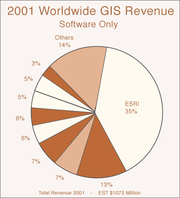
GIS Market GrowthEsri broadened its position as a strong GIS software provider, according to the latest Daratech GIS Market Report released October 2002 (see pie chart at right). Overall, GIS industry software revenues hit $1.1 billion in 2001. With 35 percent of the market share, Esri has sustained a remarkable growth rate reaching more than 110,000 organizations worldwide in more than two dozen markets. AwardsIn June, the National Association of Counties awarded Esri a Certificate of Special Recognition for its outstanding leadership and generous support to help rebuild America after September 11, 2001. In response to the tragedy, Esri supplied free software and technical support including mapping and application services to many organizations and, since then, has launched several homeland security initiatives including technology grants, training, and advanced educational materials for local, state, and federal government agencies and private organizations. The U.S. Department of State invited Esri to participate in its open forum, "A Conversation on Geographic Information for Diplomacy, Development, and Homeland Security." The forum, held July 26, 2002, also honored Esri with its Distinguished Public Service Award for outstanding contributions to national and international affairs. New PartnershipsEsri continues to strengthen its existing partnerships and build new alliances. In 2002, Esri began a new collaboration with the SAS Institute. The result is a new SAS product called SAS Bridge for Esri that will enable data and metadata transfers between SAS and Esri software and execution of SAS-stored processes from within the Esri environment (see "SAS and Esri Announce Software Link"). For users, this means they will be able to make the most of SAS intelligence such as analytics, data warehousing, data cleansing, and transformation capabilities within Esri's spatial analysis and mapping environment. www.esri.com/sas Esri is contributing and expanding its strategic partnership with Leica Geosystems in the fields of surveying land cadastral systems and image analysis and processing. Esri is increasing its focus on the utility industry and land cadastre systems in Europe, in partnership with AED-SICAD to develop in-depth application and industry expertise based on ArcGIS. GIS NetworksAt the broadest view, GIS can be seen as evolving from a project-oriented technology to becoming an integral part of an organization's information systems. Organizations, such as local, state, and even national governments, as well as private firms, have begun to share and combine their data sets as enterprise systems. An important new area of GIS, called GIS Networks, is being stimulated by new work on GIS server technology and Web services. These networks can dynamically integrate distributed GIS services into applications. To implement this distributed services architecture, Esri is embracing the standards and technology of Web services. The Geography Network was Esri's first implementation of this new architecture, which grew more than 300 percent in 2002. www.geographynetwork.com Esri Product Updates
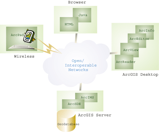
ArcGIS is an integrated system of scalable mobile, desktop, and server products. It comprises ArcReader, ArcView, ArcEditor, ArcInfo, ArcSDE, and ArcIMS that are built on industry standards and are rich in functionality. ArcGIS 8.2 was released in 2002, and ArcGIS 8.3 will be released early in 2003. ArcGIS 8.2 improved integration with ArcIMS, added an assortment of enhancements including spatial adjustment tools, management of rasters in a database management system (DBMS), improved labeling and annotation, metadata improvements, and support for new grid reference systems. At the 8.2 release the new desktop viewer, ArcReader, was introduced. www.esri.com/arcgis ArcGIS 8.2 extensions included the following:
ArcGIS Schematics 2.2.2 enables users to automatically generate, visualize, and manipulate schemas and diagrams from network data within the ArcGIS geodatabase. ArcGIS Schematics 2.2.2 operates with ArcGIS 8.2 and 8.3. A fully integrated version of ArcGIS Schematics for ArcGIS will be available at ArcGIS 9. ArcGIS Schematics SDK 2.2.2 for developers is also available. www.esri.com/schematics ArcGIS 8.3 is a major release with significant enhancements including topology and advanced editing of large GIS databases, distributed editing frameworks, management of survey measurements in the geodatabase, improved annotation editing and cartography, and many quality performance improvements. ArcGIS 8.3 addresses many advanced GIS data management tasks that have never been addressed in a modern GIS such as the ability to manage topologies or truly large continuous GIS databases (e.g., census features for the entire United States, national cadastres, and a complete orthophoto base for an entire state). This release revolutionizes the editing and maintenance of GIS databases through its use of multiuser transactional DBMSs (see "ArcGIS 8.3 Focuses on Topology and Editing"). ArcGIS 8.3 extensions include the following:
ArcSDE is Esri's application server for accessing geographic data in any DBMS. The 8.2 and 8.3 releases add support for new data types (e.g., image catalogs, vector topology, and survey data) and support more platforms including Linux (see a"Esri GIS Solutions for Linux Users"). Progress was also made in performance and documentation (particularly migration and training). ArcIMS 4 and ArcIMS 4.0.1 are Esri's latest releases for designing and managing Web mapping services. These powerful, scalable, standards-based tools enable users to create a central repository for publishing and browsing metadata over the Internet (see "Announcing ArcIMS 4.0.1"). ArcIMS is now available on Linux and HP-UX (see "Esri GIS Solutions for Linux Users"). Three additions to ArcIMS were released this year: the free ArcMap Server extension; the ArcIMS Route Server extension; and Metadata Services that are part of ArcIMS core capabilities. ArcMap Server supports ArcMap display and query functionality including full access to a geodatabase. ArcIMS Route Server allows fast, accurate routing along with point-to-point driving directions. Metadata Services support storage and access (browsing/query) to standards-based metadata about various GIS Web services. www.esri.com/arcims Other Esri Product ReleasesOther Esri software product releases include the following:
MapObjects is a collection of embeddable mapping components. In 2002, Esri introduced MapObjects--Java Standard Edition, a Java version of MapObjects. Developers can use this suite of more than 900 Java-based GIS and mapping developer components to build custom, cross-platform GIS applications or applets. The new edition also includes prebuilt JavaBeans for use in the integrated development environment. www.esri.com/mapobjects Open, Multipurpose Data Models
Esri continues to collaborate with users on the development of a series of GIS data models. The goal of these projects is to openly publish common data models that can be employed in ArcGIS as well as other GIS systems. The data models are based on generic feature standards (such as the Open GIS Consortium simple features specification) and document common Business rules for integrity and behavior. The data models are extensible and represent the essential content that will allow GIS users to openly share their data sets with other users. A major goal in 2002 was to perform real implementations through a series of case studies. These helped to verify and develop best practices and methods for GIS data modeling. Results of this work can be found at support.esri.com/datamodels or www.esri.com/datamodels (see "Introducing the 1:24,000 Scale U.S. Base Map Data Model"). ArcObjects Architecture--A Flexible FoundationFor a number of years, Esri has been investing in the development of a large GIS component library that has come to be called ArcObjects. These objects have been used as a platform for Esri's desktop products: ArcReader, ArcView, ArcEditor, and ArcInfo. We are now working on the reuse of ArcObjects in a server environment (ArcGIS server) so that the GIS functionality encapsulated in ArcObjects can be deployed as Web services or as embeddable objects for developer applications. We see our decision to develop GIS as a component architecture as strategic. It has allowed us to reuse all of the GIS knowledge acquired over more than 30 years and is now providing a very flexible platform for easily supporting new technical configurations of this knowledge. Interoperability and Standards--Standards are necessary to make GIS Networks work, and Esri is committed to developing products based on open standards and ensuring a high level of interoperability across platforms, databases, development languages, and applications. Esri supports and participates in groups dedicated to addressing issues associated with interoperability and standards. We believe the GIS community will be able to dynamically grow as a result. www.esri.com/standards Internet Services--In the latter part of 2002, Esri introduced ArcWeb USA, which is a new set of ArcWeb Services that enables GIS users and Internet developers to subscribe to nationwide GIS content and related functionality for their applications. Data services include roads, images, demographics, and topography. Geoprocessing functionality includes address geocoding, routing, and map display/query. The key advantages of ArcWeb USA involve the ability to use high-quality GIS data sets without hosting the data or service locally (see "ArcWeb USA Now Available"). www.esri.com/arcwebusa MapShop--One of the biggest users of ArcWeb Services is MapShop. This system was developed by Esri for The Associated Press and represents an online GIS tool for creating custom news maps suitable for direct use in newspapers. Users have access to timely and accurate geographic map data from global to street-level detail. In 2003, Esri is expanding this service to other organizations needing basic publication-quality cartographic services. GIS and SocietyEsri continued its support of science and education to help GIS become a universally accepted framework for geographic exploration and discovery. Programs were strengthened and enhanced at the Esri Learning Center, the Virtual Campus, and Esri Press. Esri was an active sponsor and participant in various activities including GIS Day and the My Community, Our Earth program for K-12 and higher education students (see "GIS at World Summit on Sustainable Development"). The Esri Conservation Program supports more than 4,100 groups with grants, technology, and scholarships, and Esri supports the programs of the Society for Conservation GIS. GIS Day--The fourth annual GIS Day educated hundreds of thousands of children and adults about the importance of geography and the role that GIS plays in support of geography. On November 20, 2002, more than 800 GIS Day events took place in 86 countries around the globe. (See "GIS Day 2002".) GIS Day 2003 is scheduled for Wednesday, November 19, and the National Geographic Society's Geography Awareness Week theme for 2003 is "Habitats." www.gisday.com Training--More than 70,000 GIS professionals worldwide enrolled in Esri's instructor-led software classes in 2002. Esri software training is more accessible than ever with classes available at regional offices, client sites, and international distributor offices around the world. In the United States and more than 50 other countries, Esri third party instructors now number more than 1,000. Several new instructor-led courses were developed and taught in 2002 on ArcGIS, ArcIMS, and ArcSDE, and new courses and course updates are planned to support software releases in 2003. Esri Virtual Campus--In 2002, GIS professionals and students continued to take advantage of the many opportunities offered at the Virtual Campus. Enrollments grew to more than 165,000 members representing 180 countries. Thirteen new courses brought the total number of courses available to 48, including two instructor-assisted courses supported by Pennsylvania State University's Department of Geography. Courses of note include Creating, Editing, and Managing Geodatabases by Cynthia A. Brewer, Ph.D.; and Spatial Analysis of Geohazards using ArcGIS by William Harbert, Ph.D. In 2002, 7,500 participants from 24 countries attended 14 free, live training seminars presented by experts in various subjects at the Esri campus. In addition, Web workshops were introduced to give GIS professionals more options for Esri software training (see "Free, Live Training Seminars Teach Thousands Online"). The Esri Training and Education Library has one of the largest online bibliographies of GIS with 20,000 references. Esri Press--As a publisher of high-quality books on the theory, science, and application of geographic information systems, Esri Press released many new titles in 2002 and its Getting to Know ArcGIS Desktop became the most widely adopted GIS textbook on the market. Other new titles included a large-format hardcover Salton Sea Atlas; Mapping Our World, an extremely popular GIS-based geography curriculum designed for use in K-12 education; and System for Survival, which spells out a vision for sustainable development of earth's increasingly taxed natural resources. The case for GIS in historical research got a major boost in 2002 with the publication of Past Time, Past Place: GIS for History, a critically acclaimed work by historian and GIS scholar Anne Kelly Knowles. In response to the events of September 11, 2001, Esri Press published Confronting Catastrophe: A GIS Handbook to help GIS professionals understand the lessons learned in New York and other sites from an emergency response perspective. In GIS Means Business: Volume Two, veteran reporter Dave Boyles examines the exploding use of spatial information technologies in the private sector. www.esri.com/esripress Application Services--Esri application service teams helped users develop solutions in the areas of defense; federal, state, and local governments; education; utilities; and Business. Most of these efforts involved Esri Business Partners. Projects included U.S. Bureau of Land Management (BLM)--cadastral system (see "BLM Implements Enterprise GIS in the National Integrated Land System"); NIMA, a database-driven aeronautical chart system; Cook County, Illinois--development of an integrated county parcel data management system; City of New York, Health Department--system for bioterrorism; State of Pennsylvania--system for West Nile Virus; Commonwealth Energy--integrated field-based GIS; Abu Dhabi Water and Electric Authority (ADWEA)--enterprise utility management system; PIDPA-Belgium (Provincial and Interurban Drinking Water Company of the Antwerpen Province)--enterprise water supply system (integrated with SAP); and many others. 2003 and BeyondFollowing another successful year for Esri software users and Esri itself, our commitment to the GIS community is stronger than ever. We have a number of exciting new software releases planned, which will make the work of GIS professionals both easier and applicable in even more areas of organizations. We will also continue our investment of time and resources in various initiatives to help our users solving some of society's pressing problems through the practical application of GIS technology. |