Frisco, Texas Finds Success with a Public Safety Digital Twin
By Ryan Lanclos and Christopher Thomas
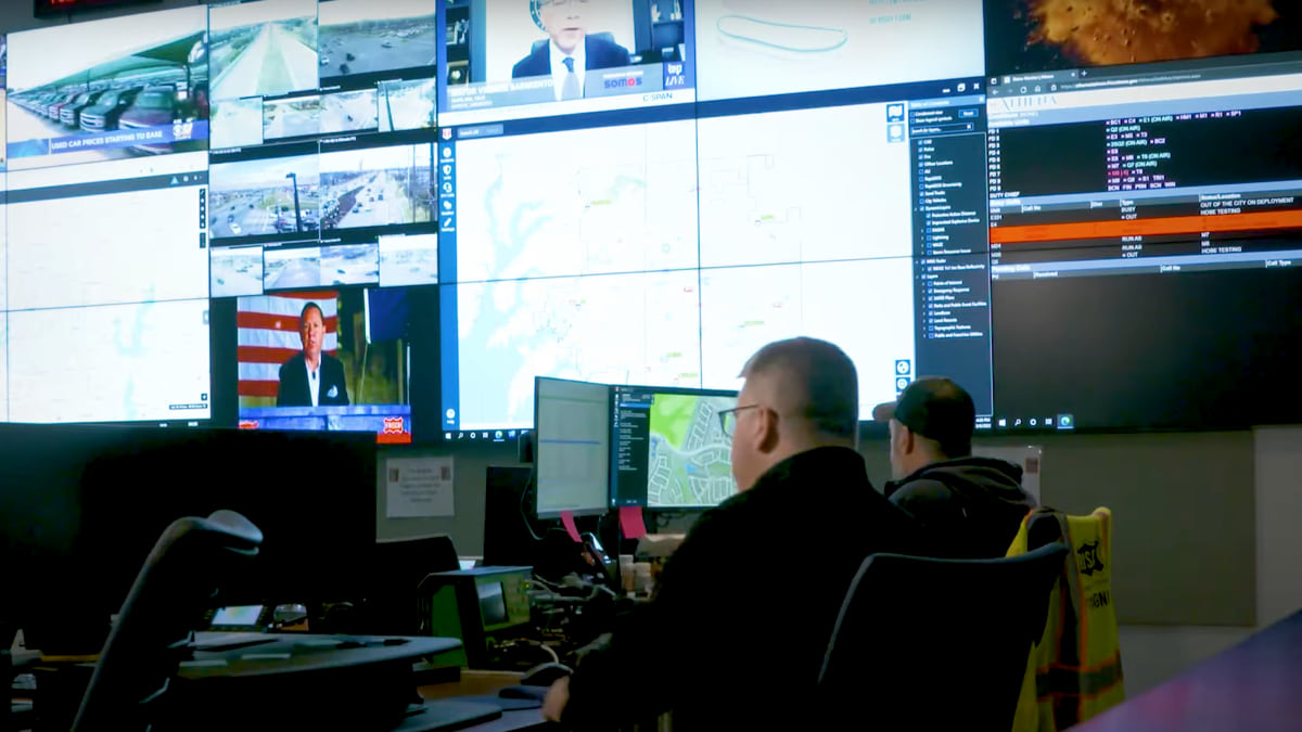
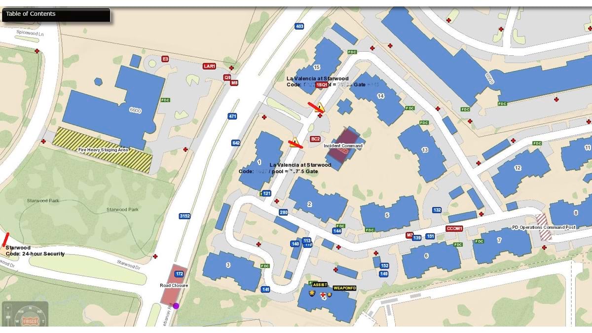
Frisco, Texas has a live map of public safety incidents and personnel locations shared across police, fire, and transportation departments. This map, a public safety digital twin, extends inside schools, allowing responders and staff to see live video of hallways. If traffic backs up, the live map is viewed by transportation engineers who can remotely change traffic signals. When incidents occur, fire and police staff use the digital twin to route themselves to calls and to coordinate response.
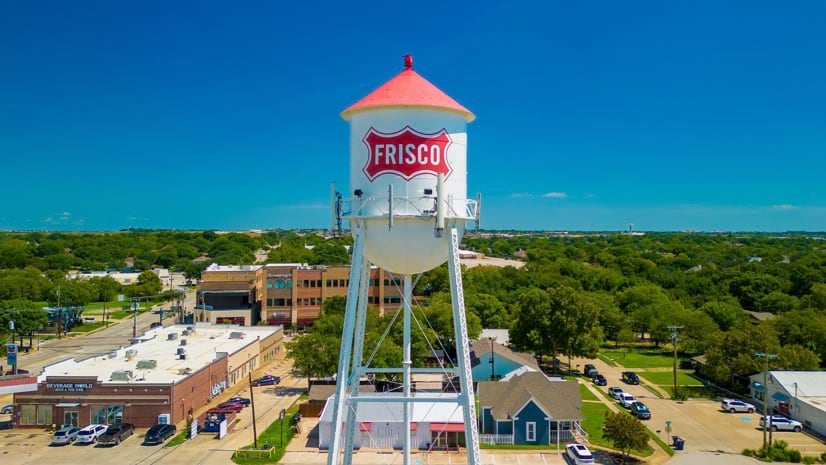
Frisco’s use of geographic information system (GIS) technology, the underpinnings of SAFER, has grown, keeping up as the city grew from 30,000 to 230,000 residents between 2000 and 2023. Safety has become a big selling point for the city. For the second consecutive year, Frisco was recognized as the safest city in the US due to its low rates of property and violent crime.
“Back when I started in 2001, we didn’t have an IT department, but city leadership embraced the power of GIS,” said Susan Olson, assistant director of IT, and lead for GIS and SAFER. “I was told, ‘We need GIS because we can’t grow without understanding our city.’”
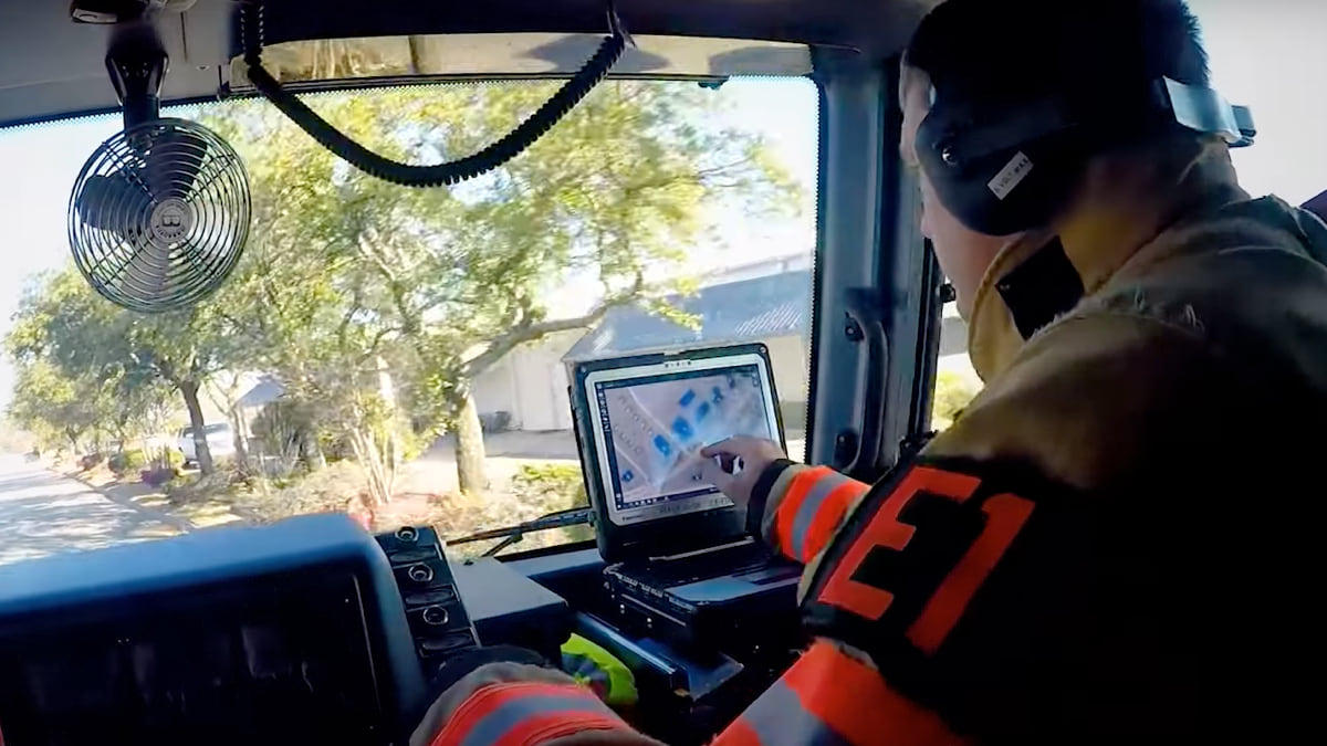
Frisco police chief David Shilson likes how SAFER provides access to information in the field for faster responses and resolutions. “In simple calls like minor accidents, dispatchers and responding officers can pull up traffic cameras through links in SAFER and determine the best approach. In larger scenes, incident commanders can look at where units are in order to quickly set perimeters and direct incoming resources.”
SAFER has gained daily use across multiple city departments, increasing collaboration among city staff. When problems occur, it provides clarity, allowing first responders to get critical information fast.
Texas state trooper Travares Webb stood his ground when a routine traffic stop turned into an intense standoff with a heavily armed man. SAFER gave Webb confidence, even after he was shot, that backup was on the way. After a tense 15-hour standoff, coordinated through SAFER, the gunman was taken into custody without causing further harm.
When a six-inch gas line was ruptured by a construction crew near a school, SAFER was used to coordinate first responder actions—including evacuation of several hundred homes in the surrounding neighborhood.
When the Frisco Fire Department responded to reports of an unknown oily, red substance in a neighborhood pond, firefighters used stormwater sewer maps in SAFER to find the source of the leak. The transmission oil was tracked to an oil change business, which was charged for the cleanup.
During the hosting of the Academy of Country Music Awards and other large events, SAFER allows public safety in Frisco to maximize the use of resources. Traffic engineers use SAFER to see conditions on the map. In many cases traffic signal automation eliminates the need for officers to physically direct traffic, freeing them for other duties.
Meeting Needs and Finding Champions
Today, SAFER supports the needs of all first responders and has become a passion project for Olson, who pioneered the system (see sidebar). She now oversees all enterprise GIS for the city. Olson first earned the trust of public safety professionals by using GIS to make sure all city roads and addresses—even those still in the planning phase—were accurately mapped.
“Often accidents and crime happen when sites are under construction,” Olson said. “We put new roads on the map when there’s a plan so everyone has awareness of where new development is happening.”
With every call for service, having the right location improved response times and outcomes. Olson then spent years delivering on the original vision of SAFER to create one shared system to respond to all calls. The system accrued a long wish list: requirements to add, data to capture, systems to integrate, staff to train, partnerships to forge.
Recently, the SAFER team refreshed and modernized the user interface and application code. They worked with other city IT staff to improve responsiveness and sustainability.
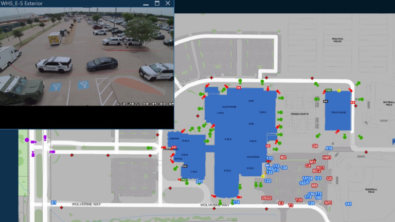
SAFER is used at all 78 Frisco schools, serving more than 66,000 students. Jon Bodie, the director of emergency management for Frisco Independent School District (FISD), compares first responders using SAFER to an orchestra working from the same sheet of music. “Campus incidents and emergencies range from routine calls to lockdowns and threat investigations,” he said. “With access to over 4,000 FISD camera feeds and floor plans, SAFER allows Frisco agencies to coordinate resource support for these emergencies in real time, ensuring students and staff stay safe.”
The idea for SAFER started with the school district. One of the first steps was integrating school floor plans with links to cameras aimed at school hallways and access points. School resource officers dedicated to each school validate that cameras are working and haven't been moved. This remote access gives responders an advance understanding of conditions before they arrive.
The Frisco Fire Department schedules yearly visits to every school to ensure that school information is up-to-date in SAFER. “The firefighters and school administrative staff work together during a fire drill to critique and identify areas of improvement,” said William Clay Carpenter, deputy chief of Frisco Fire Department. “Through this collaboration, staff from both agencies get to know one another better and strategize student safety.”
Always Updating, Adapting, Integrating
Scaling SAFER to keep pace with the city’s massive growth has required diligent attention and communication across departments. The system now integrates with more than 30 systems, including live links to traffic cameras throughout the city, real-time traffic from HERE, and it holds dozens of GIS data layers.
“We built the reliance on SAFER over time on a foundation of accurate data, strong integrations, and being responsive to needs,” Olson said.
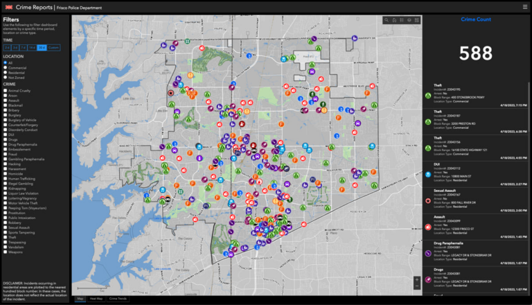
Daily, city residents use a crime map app that’s an offshoot of the SAFER system. “Our residents are very engaged and aware of their surroundings, and they let us know if the data doesn’t look right,” Olson said.
The success GIS has seen hasn’t been limited to public safety, it has also helped fuel Frisco’s growth and entice corporations to make the city their home. “When our Economic Development Corporation staff are trying to attract a company, they work with our GIS team,” Olson said. “We’ve built web apps for companies to show them all Frisco has to offer.”
Frisco has many amenities that appeal to residents and businesses looking for a place to relocate:
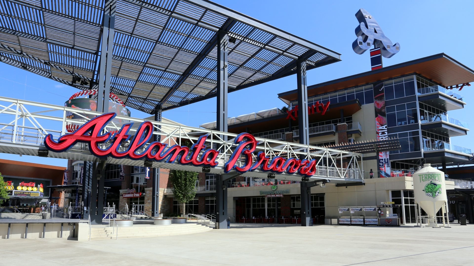
Sporting venues include Ford Center at The Star, the Dallas Cowboys’ headquarters and practice facility; Toyota Stadium, home to the FC Dallas soccer team, which will host FIFA World Cup events in 2026; the practice ice for the Dallas Stars hockey team; and Riders Field, home of the Frisco Roughriders Minor League Baseball team.
PGA headquarters recently opened, surrounded by two championship golf courses that will host 27 championship tournaments over the next 12 years. This development also includes a 10-hole lighted par 3 short course, a retail village, and the new 500-room Omni PGA Frisco Resort.
The Frisco North Platinum Corridor forms a 7-mile spine of economic development in the city with a focus on headquarters, tech, sports, tourism, and entertainment.
Universal Studios is building a theme park in Frisco, with a planned opening in 2026, that will include rides and attractions aimed at young children.
The city pioneered the public safety digital twin concept. The city’s public works and engineering groups see the value of SAFER and would like to apply the same digital twin approach to city work orders, maintenance vehicles, permitting workflows, and more.
“We’ve built this platform and it wouldn’t be that hard to duplicate for others,” Olson said. “We actually already have a name for it, but we haven’t decided to do it yet.”
Ryan Lanclos is Esri’s Director of National Government and Public Safety Solutions. He helps organizations apply the science of geography and geographic information system (GIS) technology to make a positive impact in the world. Ryan is a subject matter expert on the use of GIS for emergency management. He is an appointed member of the Federal Emergency Management Agency National Advisory Council, a representative member on the United Nations Working Group for Disasters, and a member of the Group on Earth Observations Disaster Risk Reduction Working Group. At Esri, he leads the Disaster Response Program where he has helped thousands of organizations around the world respond to crises of all types and sizes. Ryan previously served as Missouri’s first Geographic Information Officer and GIS Advisor for the Governor’s Homeland Security Advisory Council, and as the Director of State and Local Government Programs for the National Alliance for Public Safety GIS Foundation. Ryan holds a Bachelor of Arts in geology from Centenary College of Louisiana, and a Master of Science in cartography and GIS from the University of Wisconsin–Madison.
Christopher Thomas is the director of government markets at Esri and a founding team member of the Industry Marketing Department. Prior to joining Esri in 1997, he was the first GIS coordinator for the City of Ontario, California. Thomas frequently writes articles on the use of GIS by government. Follow him on Twitter @GIS_Advocate.