

April 27, 2022 |
Matt Piper | Infrastructure
Engineers at Eletrobras, a Brazilian electric utility operator, needed data. Expansion plans and maintenance requirements called for a complete picture of the network. Growing demand for renewable energy created urgency, and environmental requirements posed delays. What Eletrobras needed was a way to capture its assets and their interface with the natural world.
Valéria Carazzai, executive manager of the Department of Geotechnology at Eletrobras, faced the challenge. She knew the data Eletrobras had about its 12 hydroelectric plants, 14 wind power parks, 136 substations, and 21,000 kilometers of transmission lines. The data, however, lacked clarity and the ability for anyone across the organization to easily explore and share it.
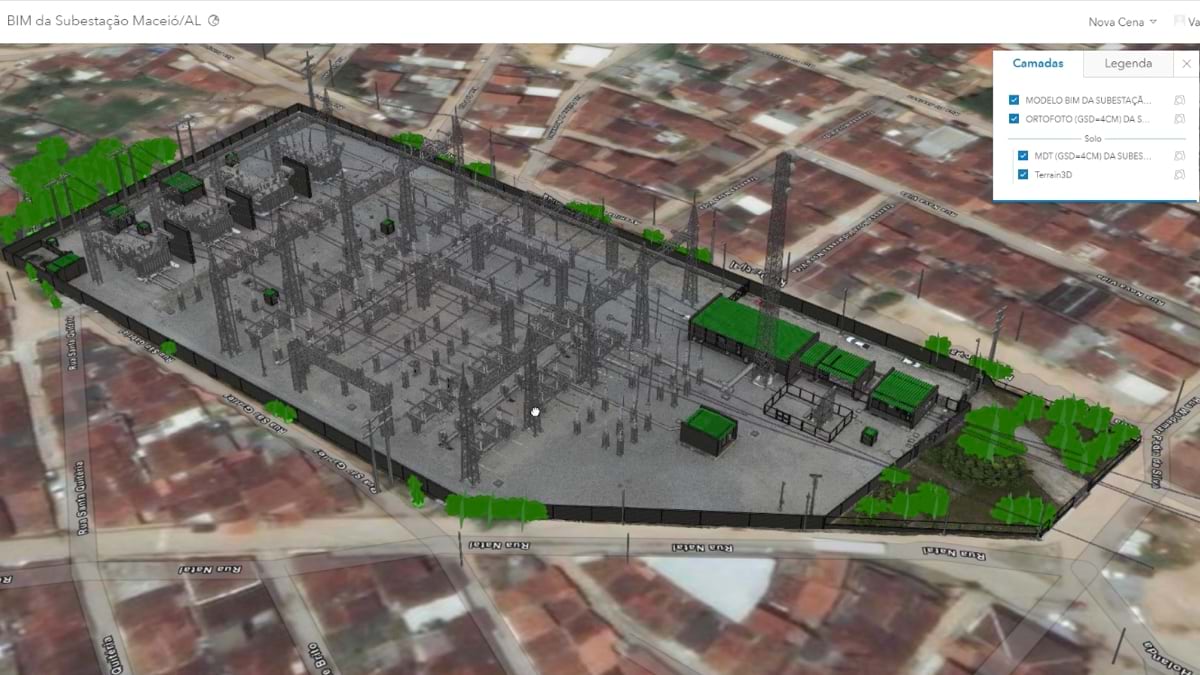
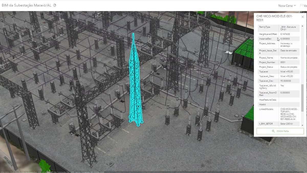
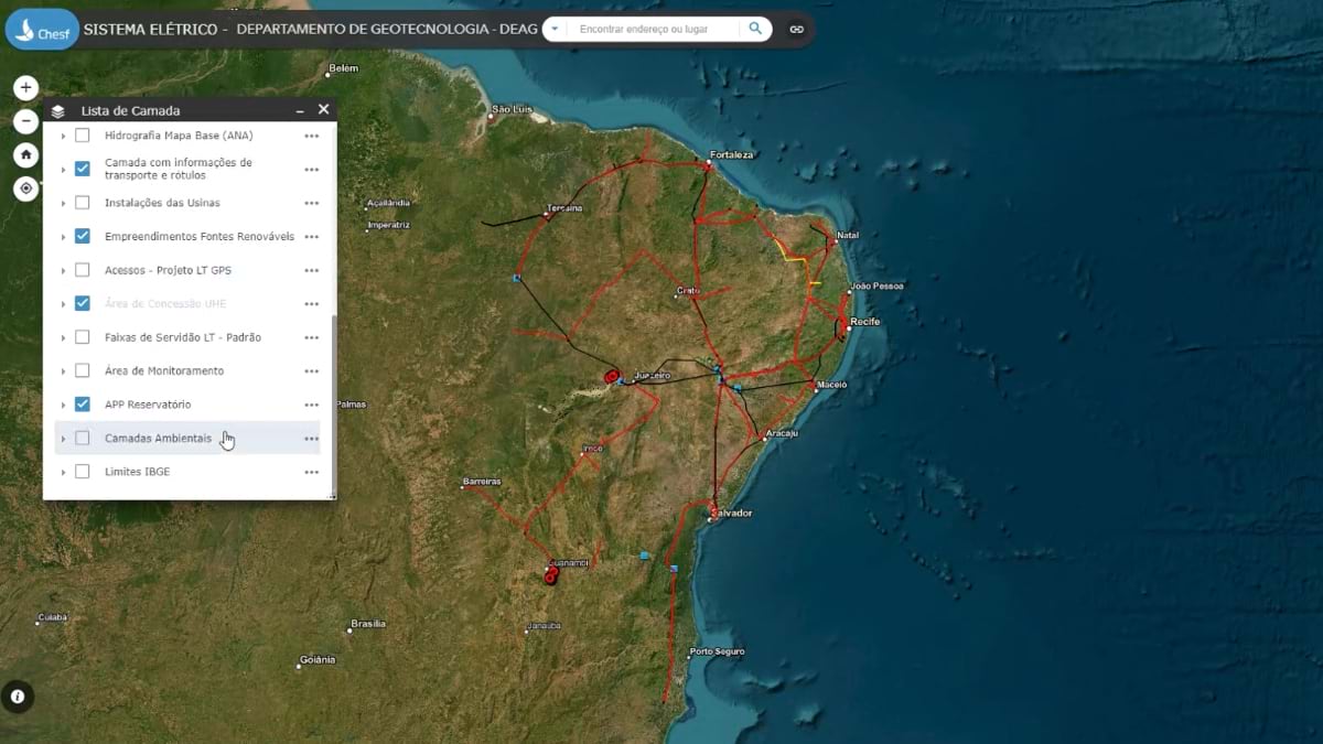
To fill data gaps, Carazzai and her team went all-in on reality capture technology. They purchased laser equipment for airborne and on-the-ground surveying. They captured imagery with drones. They incorporated building information modeling (BIM) data from Autodesk for 3D models of substations. Then they stitched the high-resolution data together using geographic information system (GIS) technology. The result was GeoPortal, a network digital twin for planning, operations, and construction projects.
“We needed everything together,” Carazzai said. “When we plan a new wind power plant, we need to go through environmental licensing, we need to know the transmission lines that can deliver the energy.”
Whenever any questions come up, anyone at Eletrobras can turn to GeoPortal for information and know what’s going on. It provides awareness of interrelationships and a foundation for decision-making.
“We build solutions with it that show the context for operations,” Carazzai said. It replaces spreadsheets that a few people used. Instead, GeoPortal captures data in the field and pushes it to the digital twin that everyone can see.
Eletrobras’s digital twin shows relationships and helps stakeholders communicate. It captures detail that designers and planners need to build more capacity. It specifies concerns about environmental impacts. It collects information needed to scope and perform required maintenance and construction. And it provides information to the communities that surround Eletrobras’s built assets and operations.
Recently, the digital twin communicated flood hazards. “It was useful first to prove the company was not guilty for what was happening,” Carazzai said. “Most importantly, it tells a story. They can see themselves there and see what has changed.”
It has been useful to relate incidents with transmission lines, helping the team learn from every toppled tower. The same information is used to put towers back up and reestablish energy to the area as fast as possible.
Carazzai’s team includes cartographic engineers, civil engineers, and geographers. These team members all specialize in geospatial data processing. In the past, this work centered on 2D maps, but now they capture reality (see sidebar).
Most utilities use contractors for surveying work, but Eletrobras wanted flexibility and has the expertise to capture details accurately. It acquired a system with four cameras and a laser scanner from Teledyne Optech and installed it on a helicopter. With it, Carazzai’s team maps the entire surface where Eletrobras’s assets are. They capture all vegetation, bodies of water, exposed soil, buildings, and Eletrobras’s improvements in 3D.
The time Eletrobras saves by making the pass in a helicopter is significant. And no longer do teams head out for days to collect data points and not gain a clear picture.
The vegetation view enables Eletrobras to keep trees away from its power lines. With the laser system, it can depict what it plans to remove. The details are then shared with the environmental agency to speed up approvals. Carazzai hopes to automate the whole process.
The digital twin gives Eletrobras an added advantage when bidding on new power generation and transmission projects. The data provides the full picture to propose designs and calculate costs, with awareness of constraints.
“The design team said it took half the time, and they want to do it in one third of the time,” Carazzai said. “We’re doing good, and we’re going to improve fast.”
How did Eletrobras come to adopt the digital twin concept? Carazzai had become frustrated that maps her team created weren’t being widely used. Yes, the maps answered key questions for the five divisional directors. But she saw the bigger pain of the lack of information flow within the company.
“Now, we’ve captured the whole asset management process, from the time information is born to implementation,” Carazzai said.
The digital twin captures so much detail. It is highly immersive and visual, which means it is highly intuitive.
Executives caught on to the value of the digital twin and pressed for expanded access across the company. Now Carazzai focuses on capturing every process.
“We worked hard to show them that we had to design each process to guarantee it captures day-to-day activities,” Carazzai said. “Without constant collecting and maintaining—integrating everything in one place—it wouldn’t be a digital twin.”
Another concern the digital twin solves is integration. GeoPortal thrives because of its ease of use. It can be accessed in any web browser from anywhere. This eliminates the need to switch between software.
“For people that cannot go to the field, they have quick access to everything important,” Carazzai said. “With a click, you have all this technical information about all equipment.”
Learn more about the Esri and Autodesk partnership to build integrated GIS and BIM solutions. Read about how GIS creates digital twins that integrate operational inputs.