November 1, 2018 |
Carl Walter | Public Safety
Part 2 of 3—Alabama Cold Case Crime Investigation
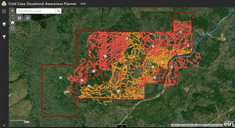
As a team of investigators rallied resources to search a 300-acre property in rural Alabama for the remains of a young woman who went missing 20 years ago, they started by mapping the property to plan on-the-ground search. As the largest search ever undertaken in the region in terms of area to scan and miles to walk, the project required a great deal of preparation. It also involved a new focus on real-time geographic information system (GIS) technology to better support the investigation’s operational requirements.
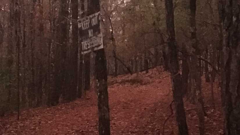
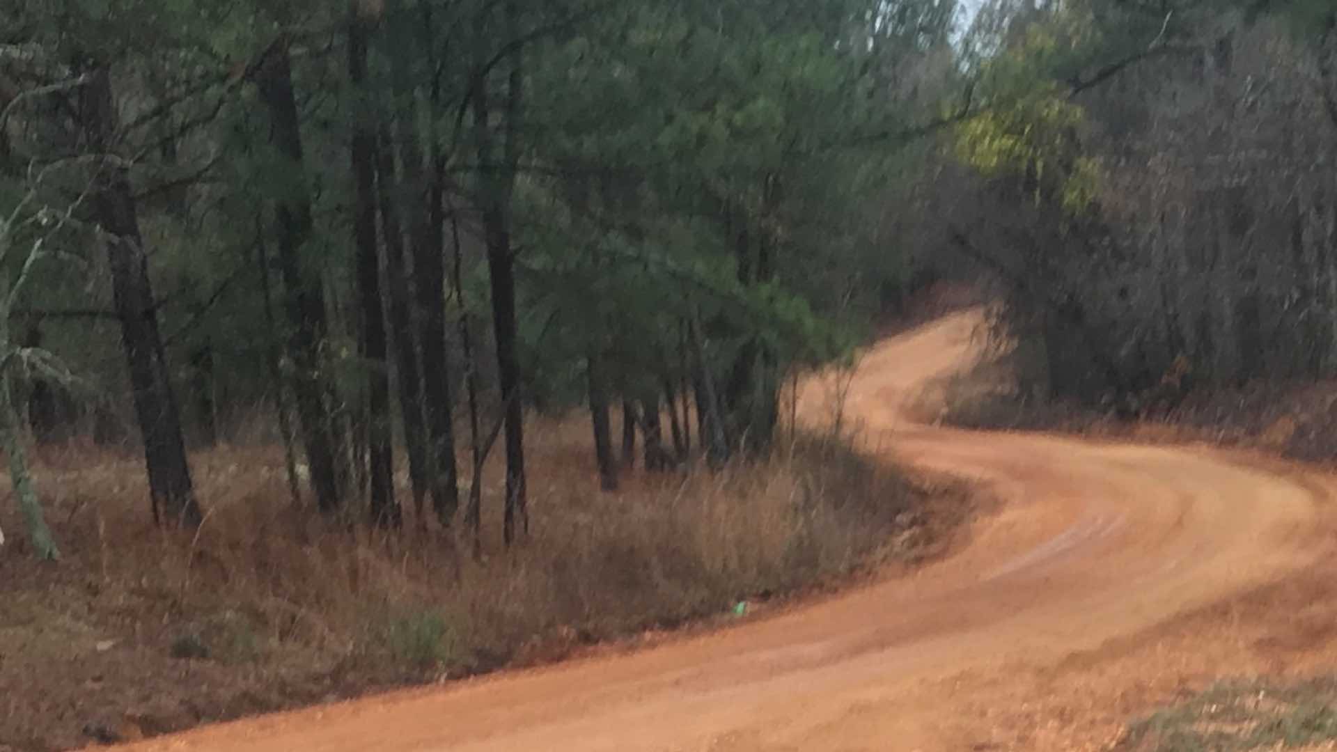
The property in question is in a remote forested area of the state, approachable only by dirt roads with a tall fence ringing its perimeter.
“We didn’t have a way to get on the property to scope it out because of the fence,” said Capt. Joe Herman of the Alabama Law Enforcement Agency (ALEA), the search commander on the case. “We tried a couple of fly-overs with an airplane and helicopter, but we weren’t really getting it because we didn’t want to get too close and alert them.”
The GIS team at the Alabama Fusion Center, those responsible for mapping and intelligence analysis, compiled aerial and satellite imagery from when the victim went missing in 1998 up until the present. They used this to identify, geolocate, and display all available information about the land (i.e. dirt roads, paths, streams, ponds, and structures) on a digital map.
“One of the first things we wanted to identify was any known structures on the property,” said Jared Bostic, deputy Geographic Information Officer for the state of Alabama. “That detail was essential for the SWAT team who were the first to go in and clear the property.”

Systematic Preparations
Searchers used the Incident Command System (ICS) to organize and manage the event. ICS provides a framework for the command, control, and coordination of large investigations. The ICS hierarchy allows personnel from multiple agencies to perform effectively as distributed teams. ICS integrates the information gathered to keep everyone informed and focused on the shared goal—in this case the shared goal was to find evidence of Traci Pittman Kegley’s disappearance.
“ICS facilitated the coordination and accountability of everybody in a scalable and flexible way,” said Marieke Fendley, Emergency Management Coordinator at the Alabama Emergency Management Agency. “It informed the incident action plan, which provided a timeline of each day of work, the assignments, the resources, and the rhythm and structure that everyone followed.”
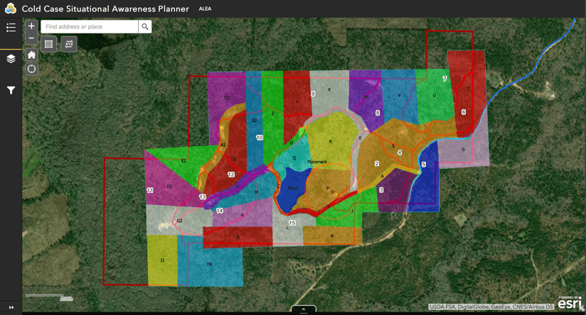
In the pre-planning phase, investigators used GIS to collect multiple sources of information about the identified property. Multiple teams digitized search grids to manage the process of canvassing the massive swath of land. Investigators presented their data in a variety of GIS web mapping applications on computers, tablets, and phones. This gave everyone involved a shared situational awareness and a way to visualize what they were walking into.

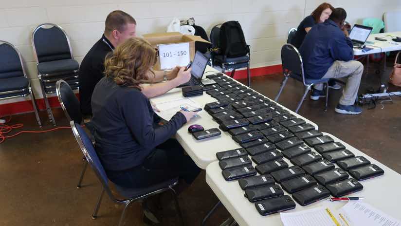
Alabama law enforcement also reached out to FirstNet, the wireless broadband network for first responders. FirstNet, built with AT&T, provided a Cellular on Wheels (COW) truck as well as 160 cellphones, enough for each of the searchers. Another COW came in from Southern Linc. Together these trucks blanketed the area with a robust wireless signal where none existed before.
The call also went out to cadaver dog teams—dogs trained to sniff out human remains—and 15 teams responded from as far away as Maryland. Cadaver dogs use their 250 million smell receptor cells (compared to 5 million for humans) to detect all five stages of human decomposition on both land and water, and these sensitive noses would be needed.
“They don’t lie to you,” said Jen Morgan with Southwest Panhandle Search and Rescue K-9 from Panama City, Florida. “It’s black and white to them, it’s either there or it’s not there.”

Commanding the Scene
As the first teams arrived on the Sunday of the week-long search—immediately following the “all clear” signal from the SWAT team—they encountered a challenging scene.
“It was covered with deer that were sick and dying,” said District Attorney Randall V. Houston, who serves Elmore, Autauga, and Chilton Counties in Alabama. “They had eaten most of the vegetation, which was fortunate for us because it made it easier for our ground teams to get in there. However, it was littered with carcasses and bones.”
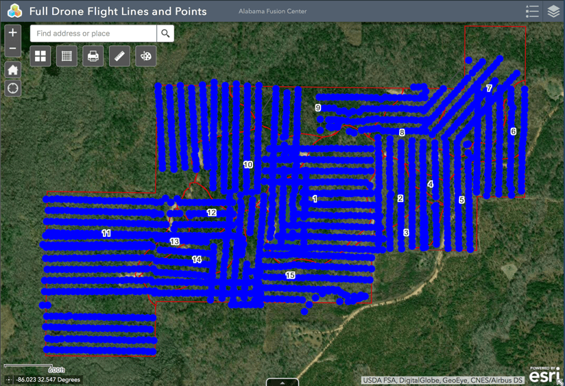
The mapping team immediately got to work flying a drone over the full extent of the property.
“The drone captured imagery of the existing conditions, giving us a brand-new and accurate basemap to conduct the search,” Bostic said.
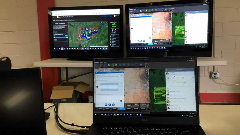
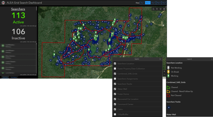
As the drone was flying, advance teams set up a forward operation base on the property and a command center at a Volunteer Fire Department facility a few miles down the road. They staged all-terrain vehicles, a portable toilet, bottled water, and other provisions on the property. Large screen televisions, Wi-Fi, and an Operations Dashboard went up at the command center, giving a quick view of progress as the search progressed.
All was set to begin the search on the next day, a Monday, with 85 to 115 agents, officers, and deputies more than 20 agencies arriving each day, volunteering their time to assist the search.

Real-Time Reports
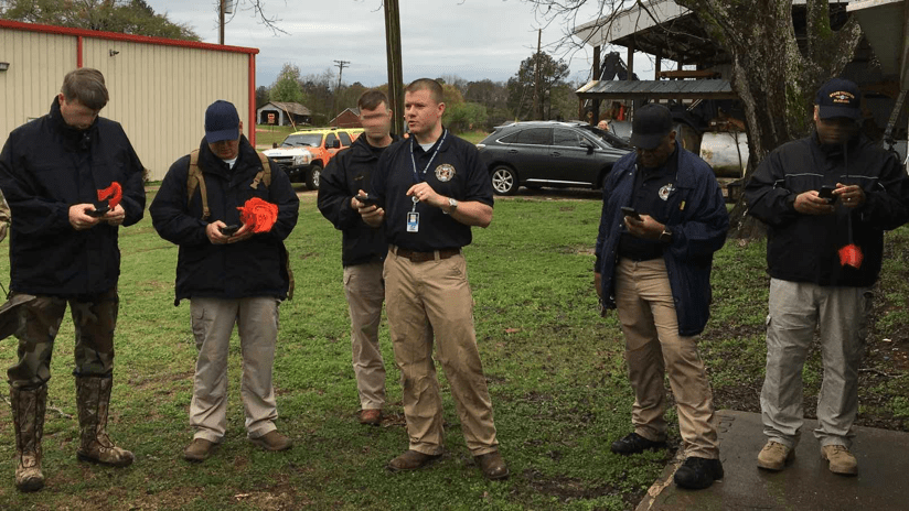
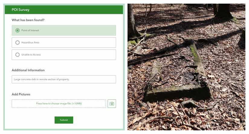
As searchers checked in, each received a smartphone which allowed the command center to see each person’s location in real time. The phones also contained a simple survey application with pull-down menus searchers used to photograph and detail suspicious points of interest during the search.
The instant any of the searchers sent a report, it would pop up within the command center for leadership to see exactly what was happening in real time. Out on the property, each team member marked their discoveries using the app and a flag.
“We always use toilet paper to flag because the first time it rains it’s gone,” said Ty Gober, retired battalion chief with Birmingham Fire & Rescue Service, and the coordinator for the ground search. “When you look through the woods you can see those flags and tell exactly where you’ve been.”
“Everybody could see that they were on the map, whether they were a dog handler, a law enforcement officer or a fireman,” said Jay Moseley, director of the Alabama Fusion Center. “It helped teamwork because they could see that we’re all important enough to be on that situational awareness map.”
The real-time awareness also provided safety assurances.
“We’ve got some mean snakes down here and the weather got warm enough that week to bring them out of hibernation,” said Ricky Roberts, Battalion Chief of the Training Division at the Prattville Fire Department and the safety officer for the search. “I was concerned that we would lose somebody. Live tracking gave me peace of mind, knowing where everybody was all the time.”
The gridded property map helped each team track progress and pick up where they left off after taking breaks.
“We knew at the end of every day, or any time I wanted to know, how much property we covered, what was covered, and what had not been covered,” Capt. Herman said.
Part one of this series sets the scene. Part three of this story speaks to the outcomes of the search. Learn more about the many ways that GIS supports public safety.