


January 24, 2023 |
Terry Bills | Infrastructure
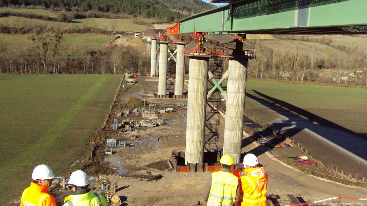
Governments across Europe are rushing to modernize aging bridges—triggered by decrepit infrastructure conditions and increased instances of collapse linked to overloading heavy goods vehicles or extreme weather conditions.
France faces a unique challenge, because a large proportion of its bridges had to be reconstructed after World War II and are coming due for major repairs or replacement at the same time.
After a study found a third of bridges in France might require repairs, the French government launched its National Bridges Program. Leading the effort is the Centre for Studies and Expertise on Risks, the Environment, Mobility and Urban Planning, or Cerema. The agency’s first step was to identify most of the country’s municipal bridges and determine their condition, collecting data and mapping results with geographic information system (GIS) technology.
“We’ve been dramatically reminded in recent years of the extreme sensitivity of road bridges,” said Thomas Plantier, director of digital transformation at Cerema. “With the 2018 collapse of the Morandi Bridge in Genoa, the French government recognized the need to survey and assess the condition of France’s bridges.”
The assessment task met with three major obstacles. First, the country has more than 36,000 road authorities, including many smaller municipalities, towns, and villages with limited financial and technical resources. Second, the sheer number of bridges that needed evaluation was staggering, with estimates of as many as 100,000. Third, the French government didn’t have an inspection program in place to determine the condition of local bridges.
There were other considerations as well, according to Plantier who noted “the theoretical lifespan of a bridge varies according to the type of structure, how it’s used, and above all, its surveillance and maintenance.” The Cerema team also had to factor in the age of each bridge and inconsistencies in ongoing maintenance.
To tackle the scope of the bridge census and assessment, Cerema staff coordinated 250 agents from 30 different contractors over a two-year period that wrapped up in 2023. Cerema also needed to establish ongoing communication with many local authorities from the 11,500 participating municipalities.
The timeline was tight as Cerema had only six months to prepare and 18 months to perform the total census.
“Such a massive program requires a dedicated information system,” Plantier said, noting the team’s specific requirements.
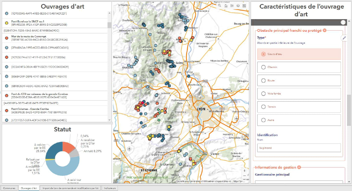
Cerema staff and contractors had to be able to enter data, including location and images, while in the field and possibly offline. In the office, they needed a database, a public map, and a health diary of each bridge and its associated retaining wall. Management wanted to visualize the data and monitor progress, and the agency had to compartmentalize contractor information for data security. Most importantly, the tools had to be easy for all stakeholders to use.
To execute the complex bridge assessment survey, Cerema gave crews access to ArcGIS Survey123, a mobile GIS app for phones or tablets.
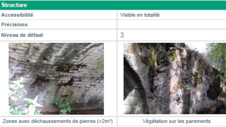
“The survey included about 150 questions for each type of structure, and there was also the 12-page health diary that required a lot of conditionality management,” Plantier said.
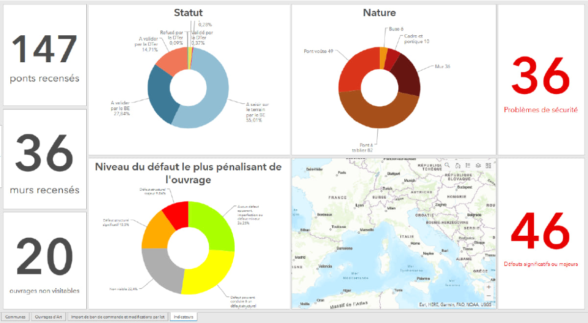
In total, the team of 250 field agents surveyed 45,000 of France’s bridges and retaining walls. Office staff created interactive dashboards using ArcGIS Dashboards to display inspectionprogress and results. Operators in the field were able to quickly adapt to the digital tools.
At the end of the census, Cerema had provided a comprehensive picture of the current conditions of thousands of bridges and retaining walls across France. An interactive online map brought together all the data and made it accessible for public use.
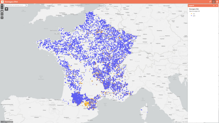
The assessment showed that 10 percent of the structures surveyed required immediate attention to ensure public safety, and 21 percent need significant repairs. Enabled by these data-driven results, renovations have already begun. Cerema has also created guides and videos to help local authorities maintain bridges into the future.
The project is ongoing. Additional municipalities—those that had declined to join the program in the beginning—have agreed to participate after seeing the census results.
“The data-driven and map-focused results of the National Bridges Program has helped solidify the role of Cerema as the authority on bridge and infrastructure quality,” Plantier said. “That data-driven effort, using GIS-based surveys, is a pattern we plan to apply for other initiatives.”
Learn more about how GIS is used to understand asset location, condition, and performance.