November 2, 2021 |
We are all acquainted with the blue dot on our navigation apps. The blue dot travels with us as we move through the world.
In one key way, it is the antithesis of the famous Pale Blue Dot—the photograph of Earth captured by the Voyager space probe from a distance of 3.7 billion miles; that image humbled us by depicting our planet as a barely discernible blip against the backdrop of deep space. Conversely, the blue dot on our apps empowers us, always making us the center of the map.
Except it’s not on all maps, and it does not follow us into all environments. Most maps represent outdoor spaces. Even when detailed indoor maps exist, our ability to locate ourselves on them has lacked precision.
The average American spends over 90 percent of life in buildings and cars. If we expand our idea of what we want mapping tools to accomplish, we realize these indoor spaces are an unexplored frontier. Recent advances in geographic information system (GIS) technology have changed the equation, giving the blue dot new places to roam.
Here’s how:
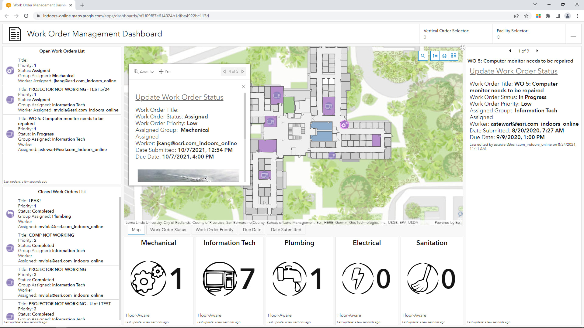
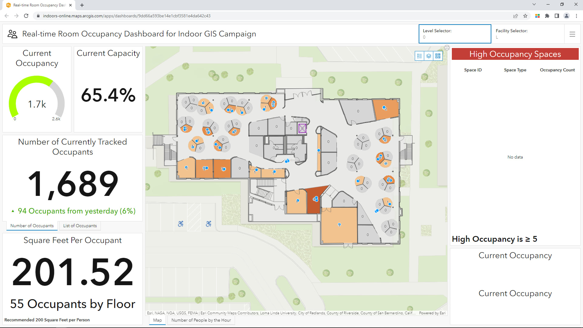
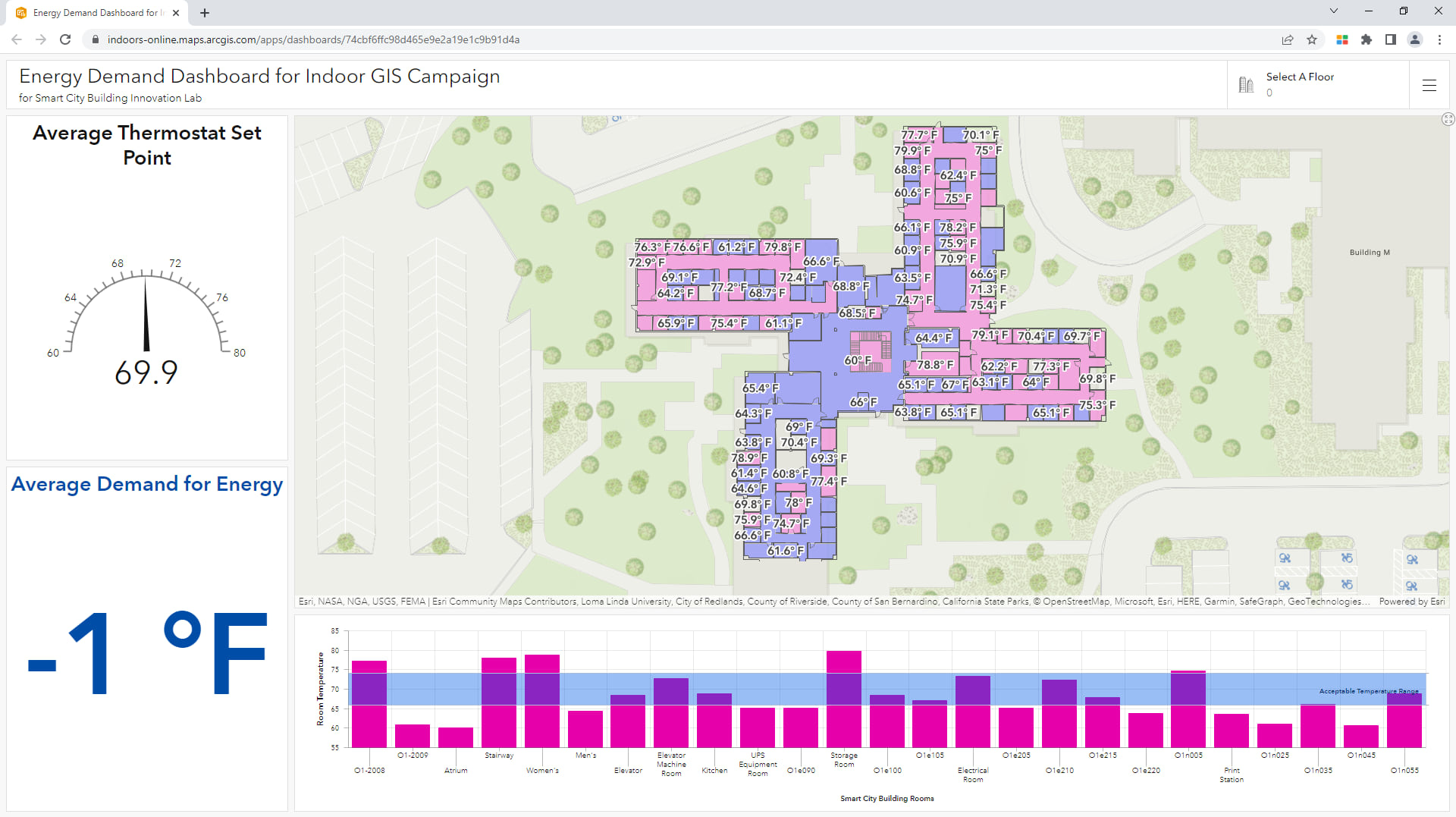
GIS makes it possible to create 2D and 3D maps of inside locations based on information from CAD drawings and building information modeling (BIM) representations. Then, indoor positioning systems use beacons for geolocation, bringing the blue dot indoors.
Aside from showing us where we are inside a building—think airports, office buildings, warehouses, convention centers—these technological solutions create new opportunities for managing, maintaining, and securing indoor spaces.
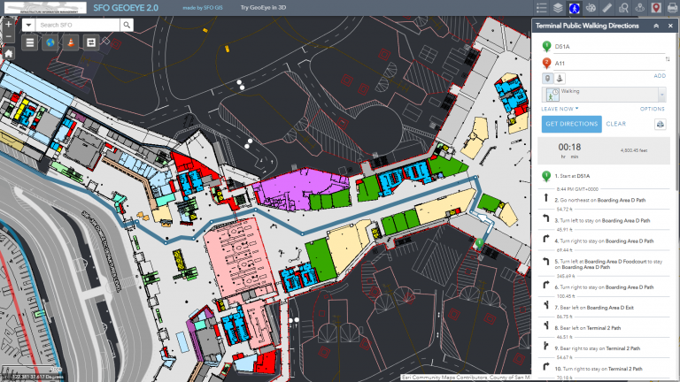
As with any map or navigation device, GIS can greatly improve wayfinding, informing the sense we have of where we are in relation to the things around us. This is especially helpful for visitors in large environments.
In a place served by indoor GIS, anyone within those confines can locate themselves on a map. In a complex environment, such as a major office building or airport, this ability to know exactly where one is at all times improves the facility’s overall flow.
In other facilities, indoor GIS can function as a full-scale digital twin—an accurate and interactive 3D model. This is particularly useful in businesses and organizations that follow a just-in-time operational framework to maximize efficiencies.
A hospital, for example, could use an indoor GIS in the same manner as an airport or any other crowded place, to help visitors find their way. When a hospital’s floor plans are turned into GIS-powered maps, any object can be geolocated. With a quick view, administrators can see which rooms and beds are free, where a needed wheelchair can be found, or whether emergency room supplies are running low.
Indoor GIS also provides a way to manage specific isolated incidents, especially involving emergencies or people in need of immediate assistance. First responders, for example, are increasingly concerned with the inability to locate people inside large buildings. Automatic geolocation of someone placing a 911 call becomes extremely problematic in an indoor environment, particularly one with more than one floor, or where vertical location is key.
In a skyscraper—or, to use the other extreme, a mine—indoor GIS can greatly facilitate this kind of response. In a crowded arena or convention space, finding the person in need of assistance can mean quickly searching a confounding environment of bustle and activity. In these instances, an easily accessible GIS map can be a lifesaver.
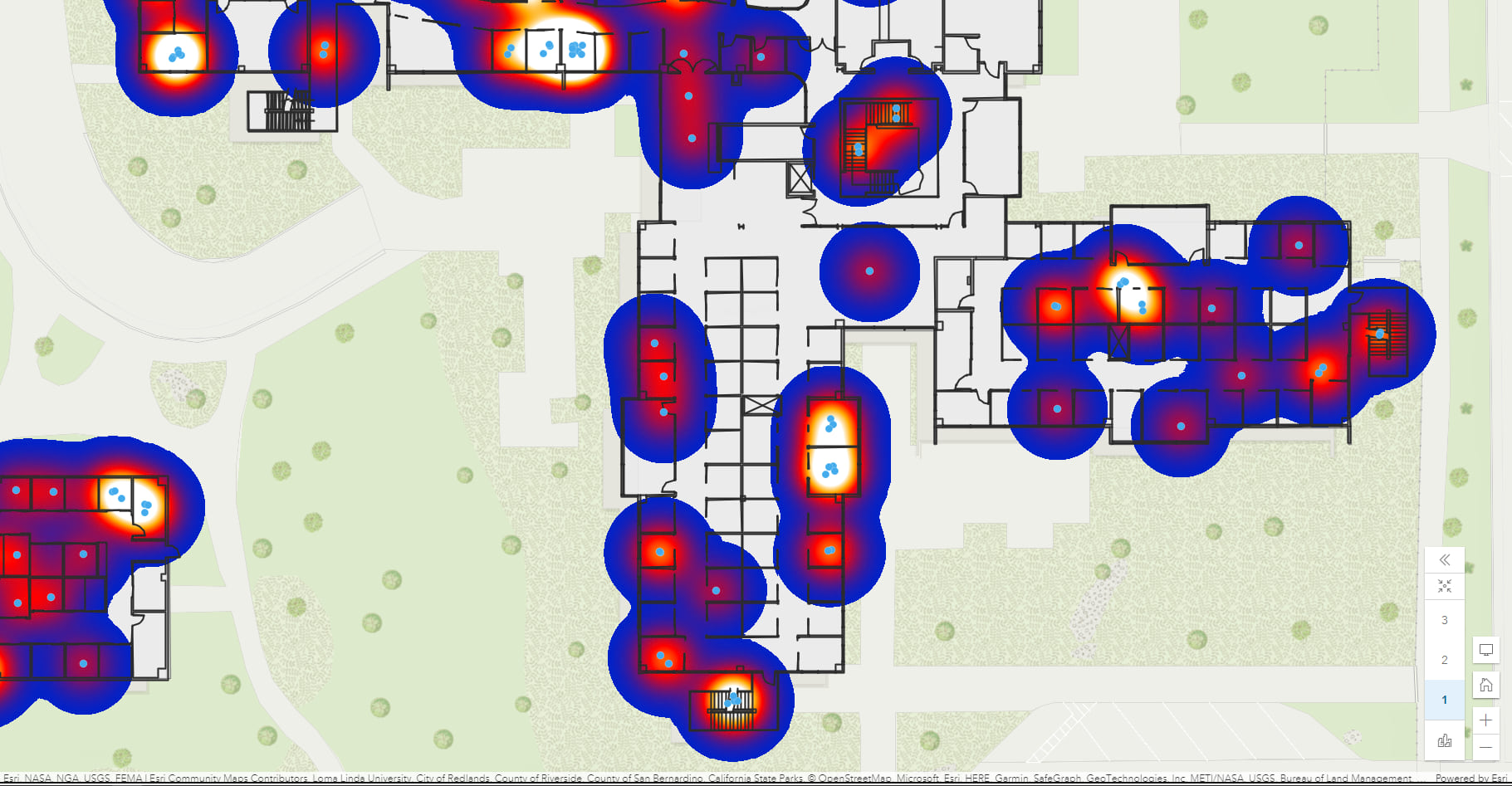
The examples offered so far have involved improving actions happening in the present, in real time. Indoor GIS also offers a way to keep records and analyze activities after the fact, looking for patterns and understanding ways to improve design. What this means, in essence, is finding a way to combine the data over time from an unlimited number of blue dots.
Indoor spaces operate by their own logic, and each is unique. By contrast, when analyzing traffic patterns on a street, for example, the flow of cars is constrained by streets, lanes, and traffic lights. But a crowd moving through an airport, shopping mall, or stadium flows in many directions at once.
These flows may proceed in ways that were unforeseen by planners, architects, and designers. Crowds can forge their own paths. Understanding these routes and habits—how much a certain exit is used at specific times, for instance—leads to improved designs and policies in the present. The analysis also offers clues for the construction of similar spaces in the future.
As the world emerges into a post-COVID-19 era, managing indoor spaces will take on tremendous importance.
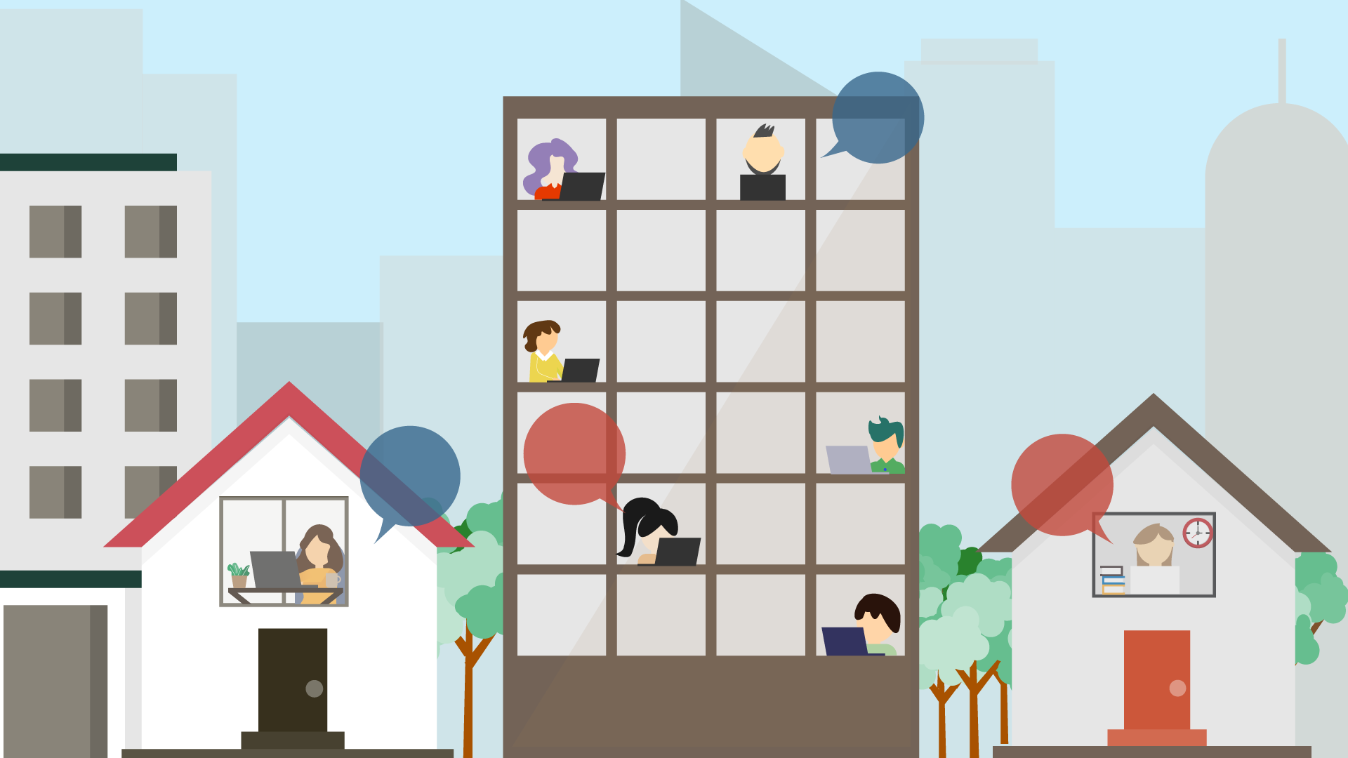
A large company looking to welcome employees back into the office might want to begin with policies that impose social distance. They may want to ensure that rooms don’t exceed a certain capacity.
That, in turn, could mean instituting policies of “hoteling,” treating the workspace with a kind of flexibility, rather than considering any space as the domain of any one person. This sort of plan would require managers to know what kind of occupancy can be expected on any given day. For employees, it could mean reserving spaces in order to know when to come to work and where to go once they get there.
As the blue dot gets better at following us inside, indoor GIS is poised to yield unique insights into the areas where we spend such a large portion of our lives. Like any frontier, we won’t know what we’ve discovered until we get there.
Learn more about how indoor mapping is being applied in workplaces.