August 22, 2023 | Multiple Authors |
October 11, 2023
The winter storms that drenched much of California from December 2022 through March 2023 refilled reservoirs. As more rain and snowmelt come, though, most will go uncaptured because the state’s outdated infrastructure was designed to swiftly carry rainwater to the ocean.
LA County aims to change that.
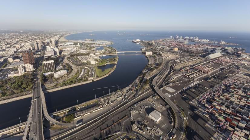
In a typical year, about 15 inches of rain falls in the Los Angeles area. Nearly half of that fell in August 2023 as the aftermath of the historical tropical storm, a remnant of Hurricane Hilary, passed through Southern California. Roughly a third of the water supply in the area comes from locally pumped groundwater that is continually replenished by percolation when it rains. Nevertheless, not all of that rain can be captured so it can be reused as drinking water or to restock the groundwater. Some years have seen more than 100 billion gallons of flow into the Pacific Ocean —which is equivalent to the water needs of more than 2 million people.
That’s a big reason voters approved Measure W in 2018. It created LA County’s Safe, Clean Water Program (SCWP), which received $280 million in tax dollars per year. Now in its fifth year, the program has funded more than 126 stormwater improvement projects. Most use solutions that mimic natural processes to increase water supply, improve water quality, protect public health, and invigorate communities. SCWP projects include green infrastructure elements such as infiltration basins, rain gardens, bioswales, dry wells, wetlands, and permeable pavement. This green infrastructure contrasts with gray infrastructure—such as storm drains which are typically built with concrete and steel—that are designed to move water underground and away from property.
SCWP administrators map and track each project using geographic information system (GIS) technology. LA residents can visit the map to see their tax dollars at work. The map provides a better understanding of each project’s role. It details relevant project information, such as the project location and the goals that will be achieved when its completed.
“Mapping provides a ‘wow’ element for us to show progress to interested stakeholders and the public,” said Kirk Allen, senior civil engineer at LA County Public Works, and lead administrator of the SCWP portal. “They can see how these projects are equitably distributed. It adds a perspective you can’t do without a map.”

At over 4,000 square miles, Los Angeles County is one of the largest in the nation, with a population of 9.8 million residents. It contains six major watersheds where rain and runoff collect and then drain into a river, lake, reservoir, or the ocean.
The Los Angeles County Flood Control District (LACFCD), administered by LA County Public Works, is one of the key stewards of these watersheds, which it manages with various infrastructure and programs. LACFCD assists in advancing the region’s pursuit of clean drinking water, recreation, and wildlife habitats. It also leads efforts to reduce potential hazards caused by flooding and mudflows.
SCWP brings together watershed and infrastructure managers, like the LACFCD, with other water agencies, local and county governments, businesses, academia, nonprofits, and others. Many of the projects developed through the SCWP program include input from community-based organizations that focus on public health and environmental conservation. For instance, in Boyle Heights, a predominantly Latino community, the City of Los Angeles Sanitation and Environment department engaged with local organization Promesa Boyle Heights during the conceptual phase of the Hollenbeck Park Lake Rehabilitation Project, and will involve them during its ongoing development. The project will beautify the park, mitigate flooding, and teach youth about water resources.
Each locally led SCWP project addresses important outcomes such as the following:
Equity is a guiding principle of the SCWP. According to researchers at the University of California, Davis, communities of color in LA lack the green space that not only cools neighborhoods but soaks up rainwater. And, these communities face the greatest burden from flooding.
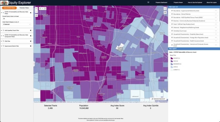
SCWP project applicants and those involved in the governance of the program are encouraged to consider the needs of the community. They have access to a variety of tools that provide awareness of equity issues, including the County of Los Angeles Equity Explorer which is a collection of data that identifies disadvantages experienced by certain communities. This map-based tool pinpoints places where historical racism and inequities in investment have happened and where land-use planning has been lacking. The SCWP prioritizes the development of projects in those communities with input from the community about the enhancements they want to see.
By focusing attention on neglected areas, SCWP collaborators aim to improve the quality of life for more people, especially those living in tree-less paved places that retain more heat. Researchers found that US residents in low-income neighborhoods endure temperatures that are hotter by 7 degrees Fahrenheit than wealthy neighborhoods. Proximity to more parks, plant life, and water bodies provides cooler places to escape the harmful impacts of heat.
“The maps help us orient projects in relation to disadvantaged communities,” Allen said. “They help us steward public dollars to help make water infrastructure more resilient and cleaner for the communities we serve.”
Along the Lower Los Angeles River Watershed Aread, one of the nine areas within SCWP, a few projects within the same vicinity collectively advance the goals of the program. The SCWP Portal, which is accessible to the public, showcases funded, completed, and ongoing projects and is a repository for project-specific information such as the benefits each project achieves.
“Having a map showcases the drainage area and community benefits,” Allen said. “The map in the SCWP portal highlights the potential relationships between projects and is a good resource to facilitate discussion among stormwater management groups. Those involved can easily analyze the map and its accompanying information, identify opportunities for collaboration, and better understand how projects (individually and working together) can contribute to the effectiveness of the regional stormwater capture system. This tool, combined with others, promotes informed decision-making, coordination of efforts, and efficient resource allocation.”
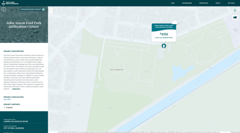
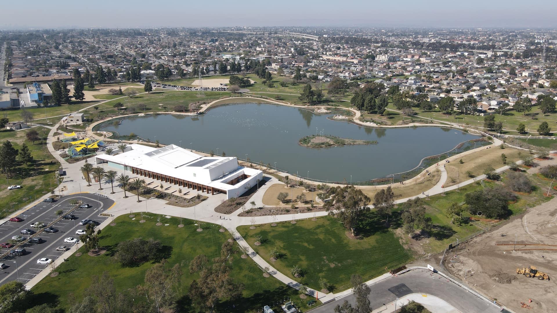
The John Anson Ford Park Infiltration Cistern project captures water under baseball and soccer fields. This park in the Bell Gardens neighborhood hosts hundreds of games in a community that is 95 percent Latino. The project diverts stormwater from the Lower Los Angeles River to recharge groundwater and reduce pollutants. Restoration efforts include new turf, trees, landscaping, irrigation, lighting, paving, and signage. The $9.9 million project will capture and treat 22-acre-feet of stormwater.
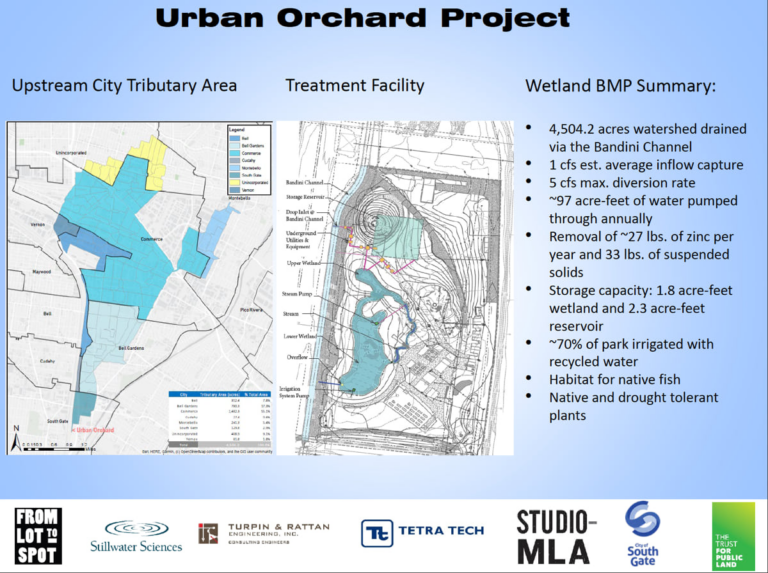
The Urban Orchard Project will turn 30 acres of post-industrial land into a grove of 200 fruit trees, a playground, and wetlands. Led by Trust for Public Land, the project’s landscaping will create shade and contribute fresh produce to the community. It will also include walking paths, native plants, and an education garden. The wetlands will provide habitat for native fish, migratory birds, and pollinators. The urban orchard will cool the air, reduce air pollution, and create 30 jobs for underserved youth. The $5.4 million stormwater retention project will capture and filter 32 million gallons of stormwater for reuse on-site.
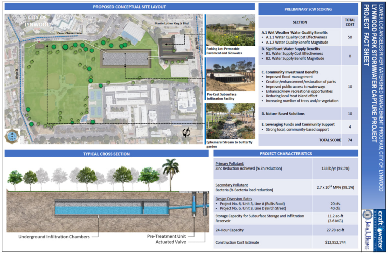
The Lynwood City Park Stormwater Capture Project enhances an existing park. It will add permeable pavement in the parking lot and an underground storage reservoir. Trees will provide shade to reduce the heat island effect and improve flood management. The restoration effort will include planting native landscapes and a butterfly garden along with two new soccer fields. The park is next to the Lynwood Youth Center and Lynwood Middle School. Educators expect to teach habitat restoration, water conservation, erosion control, and stormwater management. The $12.9 million restoration and water management project will capture and treat 647 acre-feet of stormwater.
As of August 2023, the SCWP has funded 126 Stormwater Infrastructure Program projects, 37 Technical Resources Program feasibility studies, and 18 Scientific Studies.
In the few years since Measure W passed and the SCWP has been in progress, many projects have advanced the program’s complex goals and accelerated climate resilience in Los Angeles County.
Learn more about how GIS can help protect and expand clean water access.

August 22, 2023 | Multiple Authors |
August 21, 2023 |

September 19, 2023 |